 FoxChild@Learn
3. Geological time, rocks, weathering and soils
Curriculum status: Required core content.
This guide follows the England Key Stage 3 Geography programme of study. It explains how rocks form and change, how weathering helps shape landscapes, and how soil develops at the boundary between rock, air, water and living things. The processes in this guide operate over very different timescales: a crack can widen in one winter, a soil can take centuries to develop, and a mountain belt can record hundreds of millions of years of geological change.
Required knowledge
- Describe geological time as the very long timescale over which Earth and its rocks have formed and changed. Use relative sequence and evidence such as rock layers and fossils without confusing geological time with a human lifetime.
- Distinguish a mineral from a rock and describe how mineral composition, grain size, hardness, joints, layering and permeability affect a rock’s behaviour.
- Explain how igneous, sedimentary and metamorphic rocks form. Recognise that each group includes many different rocks with different properties.
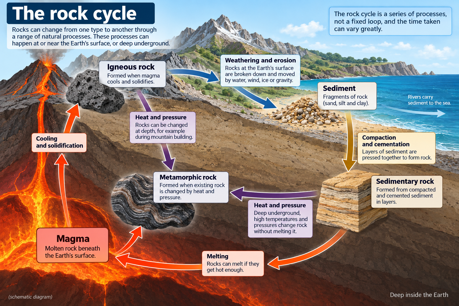
- Use a rock-cycle model to explain pathways among magma, igneous rock, sediment, sedimentary rock and metamorphic rock. Understand that the cycle has branching routes and no single start or finish.
- Distinguish weathering, erosion, transport and deposition. Explain physical, chemical and biological weathering using cause-and-effect steps.
- Explain how rock particles, organic matter, water, air and organisms contribute to soil formation. Describe how soil properties vary with parent material, climate, relief, organisms and time.
- Read a simple geological or soil map and recognise that a map shows a selected layer of evidence at a stated scale rather than the complete ground beneath your feet.
- Relate geology and soil to landscape and land use cautiously: they create conditions and opportunities, but do not determine every human decision.
Key vocabulary
| Term | Meaning and use |
|---|---|
| geology | The study of Earth’s materials, structures, history and the processes that change them. |
| geological time | The timescale used to describe Earth’s history, from its formation to the present; much longer than a human timescale. |
| mineral | A naturally occurring solid substance with a particular chemical composition and structure. |
| rock | A naturally occurring solid made of one or more minerals, or sometimes of mineral and organic material. |
| magma | Molten or partly molten rock beneath Earth’s surface. |
| lava | Molten rock that has reached Earth’s surface. |
| crystal | A solid with atoms arranged in an organised structure; crystal size in an igneous rock can give clues about cooling. |
| igneous rock | Rock formed when magma or lava cools and solidifies. |
| intrusive rock | Igneous rock that cools underground, often slowly enough for relatively large crystals to grow. |
| extrusive rock | Igneous rock formed when lava cools at or near the surface, often quickly. |
| sediment | Loose mineral or rock particles, and sometimes biological material, that can be transported and deposited. |
| strata | Layers of sedimentary rock. A stack of strata can preserve evidence of changing environments. |
| compaction | Pressure from overlying material squeezing sediment and reducing pore space. |
| cementation | Minerals precipitating from water and binding sediment grains together. |
| sedimentary rock | Rock formed from deposited sediment or from material precipitated from water, then consolidated; some types form from accumulated biological material. |
| metamorphic rock | Rock changed by heat, pressure and chemically active fluids without completely melting. |
| metamorphism | The processes that alter a rock’s minerals, texture or structure under heat and pressure. |
| rock cycle | A model of the changing pathways through which rocks and sediments form and are transformed. |
| weathering | The breakdown or alteration of rock in place, without the material first being transported away. |
| physical weathering | Breakdown into smaller fragments without changing the rock’s mineral composition. |
| chemical weathering | Chemical reactions that alter or dissolve minerals in rock. |
| biological weathering | Rock breakdown or alteration involving organisms, such as roots, burrowing animals or organic acids. |
| erosion | The wearing away and removal of material by a moving agent such as water, ice, wind or waves. |
| transport | Movement of sediment by water, wind, ice or gravity. |
| deposition | The settling or laying down of sediment when the transporting force loses energy or conditions change. |
| joint | A natural crack or fracture in rock along which movement has not necessarily occurred. |
| fault | A fracture in rock along which blocks have moved relative to one another. Faulting is considered further in the tectonics guides. |
| permeability | The ability of connected spaces in a material to allow fluid to pass through it. It is different from simply having pores. |
| porosity | The amount of open space within a material. A porous rock does not always transmit water easily if its pores are not connected. |
| soil | A mixture of mineral particles, organic matter, water and air that supports living organisms and vegetation. |
| parent material | The rock or loose deposits from which much of a soil’s mineral material develops. |
| humus | Dark, partly decomposed organic material within soil. |
| soil profile | A vertical section showing soil layers, or horizons, from the surface down towards parent material or bedrock. |
| leaching | The movement of dissolved substances down through soil as water percolates. |
| horizon | A layer within a soil profile with recognisable properties. Horizons differ among soils and are not always sharply separated. |
| relief | Differences in land elevation and slope; geology is one influence on relief. |
How the geography works
1. Geological time: reading a very long story
Earth is about 4.6 billion years old. That number is so large that it is hard to picture using a normal calendar. If all of Earth’s history were represented by a single day, a human lifetime would occupy only a tiny fraction of a second. The comparison is not an exact scientific timescale; it is a reminder that most landscape-forming processes operate far more slowly than people usually observe.
Geologists divide time into named units such as eons, eras and periods. The names help organise evidence about changes in rocks, landscapes, life and climate. For KS3, the important skill is not memorising a long list of dates. It is understanding that rock layers and fossils provide a record of past environments, and that the UK’s present landscapes combine events from different periods. For example, the British Geological Survey explains that shallow seas deposited many limestones in the Carboniferous, while later Quaternary ice sheets shaped valleys and deposited sediments.
The geological record is incomplete. Erosion may remove older layers; a period of non-deposition may leave a gap; tectonic movements can fold or fault rocks; and later deposits can cover older material. This means that a geological map is a reconstruction based on evidence rather than a complete picture of every layer underground. A rock outcrop can reveal local evidence, but it may not show the full sequence beneath it.
Relative dating describes whether one rock or event is older or younger than another without always stating an exact age. In an undisturbed sequence of sedimentary strata, lower layers are usually older than layers above them because newer sediment accumulates on top. That rule can be complicated where rocks have been tilted, folded, faulted or overturned. A fault or igneous intrusion that cuts through a rock layer must be younger than the layer it cuts, because the layer was already present. Fossils can help compare the age and environment of rocks in different places. For KS3, use these ideas to read a simple diagram, and do not assume every rock layer is horizontal or continuous.
Different evidence answers different questions. A fossil can tell us about past life and may help date a rock sequence; mineral composition helps identify the material; a geological map shows the surface distribution of mapped units; a cross-section models how layers may continue underground. A landscape photograph shows visible landforms but cannot by itself reveal their whole geological history. Combining evidence makes explanations stronger.
2. Minerals, rocks and useful properties
A mineral is a component; a rock is an aggregate. Granite, for example, is usually made from several visible minerals, including quartz, feldspar and mica. Limestone commonly consists mainly of calcite, though natural limestone can include impurities and fossils. Different mineral mixtures help give rocks their different colours, hardness, reaction to acid, density and resistance to weathering.
When comparing rocks, observations can include grain size, colour, visible crystals, layers, fossils, pores, cracks and how the sample responds to a simple test. A hand lens can reveal grains that are hard to see unaided. A weak acid may fizz on calcite-rich material, but safe classroom procedures and teacher guidance are essential. Do not taste rocks or inhale dust. Sample testing is evidence, not a guarantee: weathered surfaces, coatings and mixed composition can make identification uncertain.
Rock strength is not one simple property. A rock can be hard but highly fractured. A softer rock may be protected by a resistant cap. The direction and spacing of joints can influence where water enters and where blocks break away. Layering may create planes of weakness. Permeability determines how readily water moves through connected openings; porosity describes the amount of space available. Clay can contain pore spaces but transmit water slowly because the pores are small and poorly connected. Sandstone may allow water to move through connected pores, depending on cement and structure.
People use rock as a building material, source of minerals, energy resource or part of a landscape valued for recreation or heritage. Properties matter: a durable stone may be selected for construction, while an easily worked stone may have a different use. Quarrying can supply materials and employment, but it changes landscapes and may affect traffic, noise, dust, water or habitats. A geographical evaluation asks where materials are sourced, how they are transported, who benefits and what impacts need to be managed.
3. Igneous rocks: cooling molten rock
Igneous rocks form when molten rock cools and solidifies. Magma is below the surface; lava has erupted onto the surface. Their minerals crystallise as the molten material cools. The time available for crystal growth affects texture. Magma that cools slowly underground commonly forms visible crystals. Lava that cools quickly at the surface may form much smaller crystals, and some volcanic rocks can contain holes where gas escaped from the cooling lava.
Granite is an intrusive igneous rock. Magma cooled slowly underground, allowing crystals to grow; later uplift and erosion exposed some granite at the surface. The Dartmoor and Bodmin Moor granites are examples in south-west England, and granite is also found in Scotland. Exposed granite landscapes may develop tors and rugged uplands, but a tor’s precise shape depends on joint patterns, weathering and erosion over time. Do not describe every granite area as identical.
Basalt is a common extrusive igneous rock formed from lava. In parts of Northern Ireland, basalt lava formed the Antrim Plateau. At the Giant’s Causeway, cooling lava developed polygonal columns. The columns are not separate blocks placed by people; they formed as the lava cooled and contracted, creating a pattern of fractures. This is a useful example of how a physical process can create a distinctive landscape feature and a valued visitor destination.
Not every igneous rock forms at a volcano visible at the surface. Some magma solidifies underground in intrusions. These bodies may later be exposed by erosion. Igneous rocks may subsequently be weathered into sediment, buried and transformed into sedimentary or metamorphic rock. The rock-cycle model therefore connects igneous processes to many other pathways.
4. Sedimentary rocks: layers, fossils and past environments
Sedimentary rocks form through several pathways. Many begin when weathering breaks existing rocks into fragments. Erosion removes and transports those particles; rivers, waves, wind, glaciers or gravity move them. When transport energy decreases, sediment can be deposited. More sediment may accumulate above it. With burial, compaction squeezes the grains and cementation binds them into rock. This process is called lithification. It can take a very long time, although the rate varies with conditions and material.
Sandstone forms from sand-sized grains. Mudstone forms from much finer particles. Conglomerate contains rounded pebbles or larger clasts set in a finer matrix. The grain size and shape provide clues, but they do not reveal the whole story alone. Rounded clasts have usually been transported and worn, while angular fragments may have travelled a shorter distance or undergone less abrasion. The transport environment and later changes need to be considered.
Some sedimentary rocks form from material dissolved in water. Limestone can form from accumulated shells and skeletal material rich in calcium carbonate, or from carbonate precipitated in water. Chalk is a soft, fine-grained limestone formed largely from microscopic marine organisms. The white cliffs at Dover are a well-known example of chalk coastline; the South Downs and Chilterns also include chalk landscapes. Carbonate rocks may dissolve in slightly acidic water, creating distinctive drainage and landforms over long periods. Karst landscapes are explored further in other physical landscape guides.
Coal is a sedimentary rock formed from accumulated plant material that was buried and transformed under pressure over geological time. In parts of Britain, Carboniferous rocks include coal seams associated with ancient swamp environments. Coal supported industrial development, but extracting and burning it has environmental consequences and contributes to greenhouse gas emissions. When studying a resource, distinguish the rock’s geological origin from its present economic use and environmental impact.
Sedimentary strata can preserve fossils, ripple marks, mud cracks or other structures. These features help infer past environments. A fossil may indicate that an area was once a sea, while cross-bedding in sandstone can preserve information about moving sediment. The evidence is interpreted carefully: one fossil or one feature does not provide a complete account of an ancient landscape.
5. Metamorphic rocks: change without complete melting
Metamorphic rocks form when an existing rock is changed by heat, pressure or chemically active fluids while it remains mostly solid. The original rock, called the parent rock or protolith, may have been igneous, sedimentary or metamorphic. Mineral crystals can recrystallise; new minerals can grow; and pressure can arrange minerals into bands or layers. The rock changes, but it does not simply melt and become magma. If it melts completely and later cools, the new rock is igneous.
Slate forms when fine-grained mudstone or shale is subjected to metamorphism and develops a tendency to split along closely spaced planes. It has been quarried in parts of Wales and used for roofing and other purposes. Marble forms when limestone is metamorphosed and its calcite crystals recrystallise; it can be polished and used decoratively. Gneiss may show bands of minerals after high-grade metamorphism. These examples illustrate that the parent material and conditions influence the resulting rock.
Metamorphism can occur over broad regions where rocks are buried or involved in mountain-building processes. It can also occur next to a hot igneous intrusion, where surrounding rock is “baked” by heat; this is called contact metamorphism. In each case, the temperature, pressure, fluids and starting rock determine the changes. A simple KS3 explanation should identify the process and avoid claiming that all metamorphic rocks have the same appearance.
6. The rock cycle: connected pathways, not a fixed loop
The rock cycle is a model of how Earth materials change. Magma cools to form igneous rock. Any exposed rock can weather and erode into sediment. Sediment can be transported, deposited, buried, compacted and cemented into sedimentary rock. Existing rock can be buried and altered by heat and pressure into metamorphic rock. If rock melts, magma forms again. Uplift and erosion can expose deeply buried rocks at the surface, where weathering resumes.
The arrows in a rock-cycle diagram represent processes, not guaranteed next steps. Granite does not always become sandstone next; a granite may remain exposed, fracture, weather into sediment, be carried away, or be buried and metamorphosed. A sedimentary rock may be uplifted and eroded, buried deeper and metamorphosed, or partly melted under particular conditions. A metamorphic rock may be weathered, buried again, or melted. Many routes are possible, and parts of the cycle happen at different rates.
There is no single starting point because the cycle is continuous. A diagram that starts with magma is just choosing a convenient place to begin explaining. It does not mean Earth’s rocks all started as magma at the same time. Materials are continually being recycled at different locations and depths. Some processes take millions of years, while a small amount of surface rock can crack or be transported in a much shorter period.
Rock-cycle explanations are stronger when they name both the material and the process. Instead of writing “rock changes into sedimentary,” write “weathering breaks exposed granite into mineral fragments; a river transports and deposits some of those fragments; after burial, compaction and cementation may form sedimentary rock.” This tells the reader what happens and why a new material forms.
7. Weathering: breakdown in place
Weathering breaks down or alters rock at or near Earth’s surface. The material is not necessarily carried away. Weathering can happen at a cliff, a slope, a building or beneath soil. The three broad categories—physical, chemical and biological—are useful for learning, but real processes can work together. A crack widened by ice may let more water in; roots may exploit that crack; chemical reactions may weaken the minerals.
Physical weathering
Physical weathering breaks rock into smaller pieces without changing the minerals’ chemical composition. In freeze–thaw weathering, water enters a joint or crack. When the water freezes, it expands and exerts pressure on the sides of the opening. Repeated freezing and thawing can widen the crack until fragments loosen. This process needs water, suitable temperature changes and existing cracks. A single cold day does not guarantee that a large block will break off.
In thermal expansion, repeated heating and cooling cause minerals at the surface to expand and contract by different amounts. In some dry environments this can contribute to cracking, especially when combined with other processes. Salt crystallisation occurs when saline water enters pores or cracks and evaporates; growing salt crystals can exert pressure on the rock. Salt weathering can affect coasts and buildings, but its importance depends on local conditions.
Unloading can occur when overlying material is removed and pressure on buried rock decreases. The rock may expand and fracture parallel to the surface. This process is sometimes called pressure release or exfoliation. It illustrates how erosion at the surface can influence changes deeper in the rock. The process is not the same as freeze–thaw, even though both can create fractures.
Chemical weathering
Chemical weathering changes the minerals in rock through reactions. Carbonation is important in limestone landscapes. Rainwater absorbs carbon dioxide from air and soil, forming a weak carbonic acid. This water can react with calcium carbonate in limestone, dissolving it and carrying material in solution. Over long periods, joints and bedding planes can widen. The effect is stronger where water can repeatedly move through the rock, but rates depend on the rock, water chemistry, temperature and drainage.
Hydrolysis occurs when water reacts with certain silicate minerals, changing them into new minerals such as clay. Oxidation occurs when oxygen reacts with minerals that contain iron, producing iron oxides that may give rock a reddish or brown colour. These reactions can weaken rock or alter its appearance. Chemical weathering is often faster in warm, wet settings, but the exact reaction depends on which minerals are present.
Rainwater can become more acidic when it mixes with carbon dioxide and organic acids in soil. In the past, air pollution could also create more acidic precipitation and damage some stone buildings. Modern regulation has reduced some forms of pollution, but conservation teams still have to consider weather, moisture, salts, pollution and stone type when caring for buildings and monuments. Avoid assuming that all stone decay is caused by one chemical process.
Biological weathering
Biological weathering involves living organisms. A plant root can enter a small crack and grow thicker, putting pressure on the rock. Burrowing animals can loosen and expose material to air and water. Lichens and other organisms may release weak acids that alter minerals. The activities of soil organisms also mix organic material with mineral particles. Biological weathering is connected to both physical and chemical weathering, rather than being an entirely separate world of processes.
An organism can affect a surface without causing a large amount of breakdown. The effect depends on species, moisture, rock type, crack size and time. Tree roots can contribute to damage in a wall, but they can also stabilise soil on a slope. Geography considers both processes and consequences: the same living thing may have different effects in different locations.
8. Weathering, erosion, transport and deposition are different
These terms describe related but distinct stages. Weathering breaks down or alters rock in place. Erosion involves wearing away and removing material. Transport moves the material. Deposition lays it down. In a real landscape, stages can overlap or repeat: a pebble can be deposited, weathered later, eroded again and transported further.
Water can erode a river bank, transport sediment downstream and deposit it where the flow loses energy. Waves can erode a cliff, move sediment alongshore and deposit it on a beach. Wind can lift and transport fine particles, then deposit them where its speed decreases. Glaciers can erode and transport debris within or beneath ice, then deposit it as the ice melts. These processes are studied in more detail in the river, coast and glaciation books.
Gravity can move weathered material downslope as a landslide, rockfall, mudflow or gradual soil creep. Mass movement is not exactly the same as river erosion: gravity is the main driver, though water can increase instability by adding weight, reducing friction or weakening material. A steep slope, weak rock, heavy rainfall, undercutting and vegetation removal can all contribute in different combinations. One event may have several causes.
This distinction helps with explanation. “The rock was weathered” tells us it broke down or altered. “The river eroded the bank” says a moving agent wore away and removed material. “The current transported sand” explains movement. “The sand was deposited on a bar” describes where the material settled. Each verb says something different.
9. How soil forms
Soil forms through the interaction of mineral material, organic matter, water, air and living organisms. Weathering contributes mineral particles from bedrock or loose deposits. Leaves, roots and organisms add organic material. Micro-organisms and small animals break down remains and help mix the soil. Water moves particles and dissolved substances; air fills some pore spaces and supports soil organisms and roots. Soil develops over time, but its rate and characteristics vary.
Five broad influences help organise soil formation: parent material, climate, organisms, relief and time. Parent material affects mineral content and texture. Climate affects temperature, rainfall, weathering and decomposition. Plants and animals add organic matter and alter structure. Relief affects drainage, erosion, sunlight and the movement of water downhill. Time allows processes to act and horizons to develop. Human land use can also change soil through cultivation, drainage, compaction, pollution, vegetation removal or conservation.
Soils do not develop in a sealed container. Water may carry dissolved substances downward or remove fine particles from the surface. Roots may hold soil together; ploughing may loosen it; livestock may compact it; a slope may carry particles away during heavy rain. The balance between formation and loss matters. Soil can be a slowly renewed resource: if erosion removes it faster than it forms, soil depth and fertility may decline.
Texture describes the proportions of sand, silt and clay particles. Sandy soils often drain relatively quickly and may hold fewer nutrients than finer-textured soils. Clay-rich soils can hold water and nutrients but may drain slowly and become sticky when wet or hard when dry. Loam contains a mixture of particle sizes and organic matter and can support productive plant growth, but soil fertility is not guaranteed by texture alone. Structure, acidity, nutrients, organic matter, drainage and management also matter.
Soil pH affects which plants can access nutrients and which organisms thrive. Soil acidity or alkalinity relates to parent material, water movement, organic matter and management. The same parent rock may produce different soils where climate, vegetation, slope or drainage differs. Conversely, similar-looking soils can develop from different parent materials. To understand a soil, combine field observations with tests and local evidence rather than guessing from colour alone.
10. Soil profiles and horizons
A soil profile is a vertical section through soil. A simplified profile may include a surface litter layer of partly decomposed plant material; a darker topsoil rich in organic matter and roots; a subsoil where some materials have accumulated or where there is less organic matter; and parent material above or mixed with bedrock. Textbooks use labels such as O, A, B and C horizons, but real profiles may have fewer, more, or less distinct layers. The diagram is a teaching model, not a claim that every soil has identical layers.
Topsoil is often the most biologically active layer. It may contain roots, decomposing leaves, soil animals, air, water and mineral particles. A darker colour can suggest organic matter, but colour is not a perfect measurement of fertility. A grey or mottled layer can indicate prolonged wetness or changing oxygen conditions. A pale layer may have lost some minerals or organic matter through leaching. These clues require context and, where important, proper soil testing.
Water moves through soil by infiltration and percolation. Some water is held in tiny pores; some drains through larger connected pores; some runs across the surface. When rain falls faster than the ground can absorb it, or when soil is already saturated, surface runoff may increase. The speed of infiltration depends on soil texture and structure, compaction, slope, vegetation and rainfall intensity. The hydrology guide develops these pathways at drainage-basin scale.
Compare soil profiles carefully. Record horizon depth, colour, texture, root abundance, stone content, moisture and any boundary changes. Use the same method and units at both sites. A field observation might be “the topsoil at Site A is darker and contains more visible roots than the subsoil below it.” An inference could be “this may indicate more organic matter near the surface.” A causal explanation requires additional evidence, such as vegetation, drainage or laboratory results.
11. Soil erosion and conservation
Soil erosion occurs when wind or water removes soil particles. On bare or cultivated slopes, rainfall can detach particles and runoff can carry them downslope. Wind can remove dry, exposed fine material. Loss of vegetation, overgrazing, poorly timed cultivation, construction and repeated vehicle use can increase vulnerability in some settings. The effect depends on soil type, slope, rainfall, wind, management and the amount of protective cover.
Soil compaction happens when pressure from machinery, animals or people squeezes pore spaces. Compacted soil may absorb water more slowly and restrict root growth. This can increase runoff in some conditions. Waterlogging occurs when soil remains saturated and air spaces are reduced. It can harm some crops and plants, although wetland species are adapted to such conditions. “Wet soil is always bad” is therefore too simple; the effect depends on organisms and land use.
Conservation methods aim to reduce loss and maintain soil function. Examples include keeping vegetation cover, planting cover crops, contour ploughing on suitable slopes, hedgerows, reduced tillage, shelter belts, controlled grazing, maintaining field margins and avoiding traffic when soil is very wet. Each method has limits. Contour ploughing can slow runoff but may not be suitable on every slope; trees can protect soil but need space and time; reduced tillage must be matched to crop and soil conditions. A good evaluation weighs effectiveness, cost, time, food production, biodiversity and the needs of people who manage the land.
Soil also stores carbon, filters water, supports biodiversity and contributes to food production. Development can seal soil beneath roads and buildings, reducing infiltration and removing agricultural or ecological functions. Protecting soil is therefore connected to flood management, climate and land-use planning. A complete decision includes both benefits from development and the long-term value of healthy soil.
12. From geology to relief and land use
Geology influences relief through differences in rock resistance, structure and permeability. Where resistant rock lies beside weaker rock, erosion may remove the weaker material more quickly, leaving a ridge or escarpment. Granite can form rugged uplands because it is generally resistant, while softer rocks may form lower ground. But this is not a universal rule: landscape depends on rock structure, climate, rivers, ice, mass movement, uplift and the length of time processes have operated.
Permeability affects water movement and drainage. A permeable rock may allow water to infiltrate and be stored underground, while an impermeable layer can encourage surface runoff and springs where the two meet. Jointed chalk or limestone may transmit groundwater, yet clay-rich superficial deposits above the bedrock can change surface drainage. This is why “the geology beneath the surface” and “the material at the ground surface” may be different. Geological maps sometimes separate bedrock from superficial deposits.
Rock and soil properties can influence farming and settlement. Fertile soils, reliable water and gentle slopes may support intensive cultivation or dense settlement. Thin, acidic or poorly drained soils may be used differently. Steep slopes can raise the cost of roads or buildings, while a valley may offer a route. These links are possible relationships, not fixed rules. Modern fertilisers, drainage, irrigation, engineering, transport and markets can alter what land is used for, sometimes creating new environmental pressures.
Compare places using a chain of evidence: mapped rock type → likely properties → observed relief or drainage → soil and vegetation → land use. At each arrow, ask what evidence supports the connection. For example, if a limestone area contains dry valleys, do not immediately claim that limestone caused them; check whether the rock is soluble and permeable, whether streams disappear underground, and whether the map shows the relevant landscape. A geographical explanation is a testable account, not a guess based on a rock name.
13. UK examples: different rocks, different histories
The UK contains rocks formed in many geological periods and environments. In north-west Scotland, some rocks record very ancient geological histories. Carboniferous rocks across parts of Britain include limestones, sandstones, mudstones and coal measures associated with seas, rivers and swamp environments near the equator at that time. Later Mesozoic rocks include chalk deposited in marine conditions. Quaternary ice and meltwater then reshaped many regions and spread superficial deposits over older bedrock.
The Dartmoor granite formed underground and was later exposed. Its landscape includes tors and moorland, but vegetation, drainage, climate and management also affect how the area looks today. Granite has been quarried and used as a building material. Mining and quarrying can leave evidence in the landscape and create employment, while also producing environmental and land-use conflicts.
The Peak District includes contrasting limestone and gritstone areas. The limestone of the White Peak and the gritstone edges of the Dark Peak differ in geology and landform. Carboniferous limestone formed in a shallow tropical sea when Britain was near the equator. It is soluble in weakly acidic water, and long-term solution can contribute to caves, underground drainage and dry valleys. Gritstone is a sandstone and can form characteristic edges and moorland. The two landscapes also support different land uses, though farming, tourism and conservation are present across the wider park.
The Giant’s Causeway in Northern Ireland is associated with basaltic lava and cooling joints that formed polygonal columns. The Antrim Plateau preserves a wider volcanic landscape. Its landforms are valued for geological heritage and tourism; managing paths and visitor access protects both people and the site. A photograph of the columns can show their shape, while a geology explanation tells how cooling and contraction produced the joint pattern.
Chalk landscapes in southern and eastern England include the South Downs and parts of the Chilterns. Chalk is a porous and permeable limestone that can store groundwater, though local superficial deposits and fractures affect actual flow. Chalk downland has been shaped by erosion, weathering and land use over long periods. Farming, settlements, transport and conservation influence the present landscape. Do not assume that every chalk area has the same soil, drainage or land use.
Slate landscapes in parts of Wales record metamorphism and quarrying history. Roofing slate has been extracted where rock structure allows it to split into thin sheets. Slate quarrying has affected settlement, employment and landscape; abandoned workings and transport routes provide evidence of that history. The same slate-bearing landscape is also valued for scenery and outdoor recreation. The case shows that geology can influence an economy, while human activity changes the landscape in return.
These examples can be compared through common questions: What type of rock is present? How did it form? What properties does it have? What relief or drainage is observed? How have people used the area? What evidence supports each link? Using the same questions helps compare places without forcing them into a single pattern.
Place example
Peak District: limestone, gritstone and landscape contrast
The Peak District is an illustrative example of how geological structure contributes to contrasting landscapes within one region. It is not a required national case study; a teacher may choose another local area. The White Peak is known for its Carboniferous limestone, and the Dark Peak includes extensive gritstone uplands. Both are part of a varied landscape with settlements, farms, rivers, recreation and conservation.
The limestone formed in a shallow sea when the area lay in a tropical setting near the equator during the Carboniferous Period. The rock contains calcium carbonate and can be dissolved by slightly acidic water. Rainwater moving through joints and bedding planes gradually enlarges openings. In some limestone areas, surface streams may sink underground and flow through caves before reappearing at springs. Dry valleys can remain where river water once flowed at the surface or where drainage has shifted underground. Each feature needs field or map evidence; not every limestone site has every landform.
Gritstone is a sandstone made of grains that were deposited, buried and cemented. At the edges of the Dark Peak, gritstone forms exposed escarpments and moorland. Differential weathering and erosion can leave resistant layers standing above weaker material. Joints and bedding influence the shape of outcrops. Vegetation, peat, drainage and land management also help shape the present moorland environment.
Geology interacts with water and land use. Limestone can act as an aquifer because water moves through pores, joints and enlarged solution openings. That groundwater can be an important resource, but it may also be vulnerable to contamination where water travels quickly through fractures. Gritstone and overlying soils have different drainage characteristics. The actual water system depends on the arrangement of rock layers, fractures, superficial deposits, rainfall and land management.
Farming varies with slope, soil, drainage and access. Some limestone areas have grassland and dry-stone walls; some higher gritstone areas have moorland grazing and peat. These are broad observations, not rules for every field. Tourism and recreation support local economies through walking, climbing, cycling and visits to villages and landscape features. Visitor pressure can cause path erosion, parking problems, disturbance and conflict with farming or conservation. Management may involve path repair, visitor information, parking arrangements and habitat protection.
To investigate this contrast, use a geological map to locate bedrock units, a topographic map to compare elevation and slope, and a photograph or field sketch to identify surface features. If you use water-quality or land-use data, record the sampling site and date. A local photograph may show a limestone pavement, but the geological map can show whether the photographed area is actually underlain by limestone. A field observation can describe a dry valley; additional evidence is needed to infer why it formed.
An extended answer might argue that geology is an important influence on Peak District landscapes because contrasting rock types have different origins and properties. It should also recognise that ice, rivers, weathering, vegetation, farming and tourism have shaped the region. The strongest conclusion distinguishes a physical condition from a human response: limestone helps create conditions for underground drainage, while water supply, land use and settlement also depend on infrastructure and decisions.
Maps, data and evidence
Reading a geological map
Start with the map title, key, scale, date and source. A coloured polygon usually represents a mapped geological unit; the colour alone has no universal meaning. Use the legend to identify the rock type, age or formation. Lines may show contacts, faults, folds or other structures. Geological maps can display bedrock, superficial deposits, or both. The BGS distinguishes bedrock from superficial deposits because soil, sand, gravel, clay or glacial material may cover the older solid rock beneath.
A geological map is a two-dimensional view of mapped materials at or near the surface. It is not a photograph of every layer below ground. A cross-section uses map information and geological interpretation to model how the rocks may continue underground. Boreholes, quarries and exposures can provide additional evidence. A national map gives a useful overview, while a more detailed map is needed for local decisions.
BGS map viewers allow users to explore geology by place and switch between different data layers. When a map shows several layers, read the selected layer name: a bedrock map and a superficial-deposits map can show different patterns for the same site. Check map date and scale because a generalised national layer may omit details visible on a local map.
Interpreting a rock sample or photograph
Record observations before naming the rock. Note visible grain size, crystal shape, layering, fossils, holes, colour and breaks. Ask whether crystals fit together, whether grains are cemented, or whether minerals form bands. Consider whether a weathered surface might hide the fresh rock. A single sample may not be representative of a large formation, and a photograph can change colour under different light.
Use a simple identification table to compare evidence:
| Observation | Possible clue | What else to check |
|---|---|---|
| Large interlocking crystals | Slow cooling may have occurred | Whether several minerals are visible; sample context |
| Very small crystals or a fine groundmass | Rapid cooling of lava is possible | Holes, flow texture, volcanic setting |
| Layers of differently sized grains | Sediment may have been deposited in stages | Whether bedding is natural; grain shape and cement |
| Fossil fragments or shells | A sedimentary marine or lake environment is possible | Fossil type, rock chemistry and geological context |
| Mineral bands or aligned crystals | Metamorphic change may have occurred | Whether foliation or banding is visible across the sample |
| Fizzing with suitable dilute acid | Carbonate minerals may be present | Safe procedure; whether surface coatings affect result |
These clues are not an automatic answer key. Rocks can be altered, weathered, mixed or mislabelled. Use multiple observations and compare them with a trusted geological source. In a field study, photograph the sample in place before moving anything, record location, and follow access and collecting rules.
Comparing soil profiles
Use a clear, repeatable method. Select safe sites with permission. Avoid digging near buried services, unstable ground, contaminated land or protected habitats. If sampling is not appropriate, use an existing soil pit, an image or an approved dataset. Record the slope position, vegetation, land use, recent weather and visible drainage. Measure horizon depths from the surface and use the same units at each site.
Compare colour, texture, structure, roots, stones, moisture and depth. A simple texture test can estimate whether soil feels gritty, smooth or sticky, but it is only an estimate. A laboratory test can measure pH or nutrient content more consistently. If you compare cultivated farmland with a woodland, differences may relate to vegetation, management, parent material, drainage or time. Do not attribute the result to one factor without evidence.
Use data to test an explanation
Suppose you want to investigate whether slope affects visible soil erosion. Write a testable question, such as “Does bare soil cover increase with slope angle along this transect?” Identify what you will measure, how many sites you will sample, where each sample will be taken, and what other conditions might affect the result. Use a clinometer or map to estimate slope, record ground cover using the same method, and note soil type and recent rainfall.
Present the measurements in a table or scattergraph. A positive relationship may suggest that steeper sampled slopes have more bare soil, but it does not prove that slope caused the pattern. Vegetation, foot traffic, grazing, soil texture and drainage may also matter. State the sample size, sites and limitations. A conclusion should answer the question using evidence, then explain the likely process and alternative factors.
Geology, map scale and uncertainty
A small-scale national map covers a wide area but simplifies detail. A large-scale local map shows a smaller area with more detail. The map scale therefore affects what patterns you can see. A boundary between units may be mapped precisely enough for regional study but not suitable for deciding where to place a building without a detailed site investigation.
Geological boundaries can be inferred beneath soil or water where rock is not exposed. Maps use observations, boreholes and interpretation, so some uncertainty is unavoidable. A map should be treated as a scientific model with a stated level of detail. For school geography, it is usually enough to identify the broad rock types and explain that local ground conditions can vary across short distances.
Common misconception
- “A mineral and a rock are the same thing.” A mineral has a defined composition and structure; a rock is a material made from one or more minerals or other components.
- “All rocks fit neatly into one appearance.” Each of the three major groups contains many varieties. Texture, composition and formation conditions differ.
- “The rock cycle is a one-way loop with a fixed starting point.” The cycle has many pathways, and a diagram’s starting position is chosen for convenience.
- “Magma and lava mean the same location.” Magma is below the surface; lava has reached the surface.
- “Metamorphic rock has melted.” It is altered mainly in the solid state. Complete melting followed by cooling forms igneous rock.
- “Weathering and erosion are synonyms.” Weathering breaks or alters rock in place; erosion removes material.
- “A pebble is sedimentary rock.” A pebble is a fragment of rock or mineral. Sedimentary rock forms after deposited material is consolidated.
- “Every sediment becomes rock quickly.” Burial, compaction and cementation usually take a long time, and much sediment is re-eroded before lithification.
- “Soil is only broken rock.” Soil also contains organic matter, water, air and living organisms.
- “Every soil has the same set of clear horizons.” Profiles vary with parent material, climate, organisms, relief, time and management.
- “Dark soil is always fertile.” Colour can provide a clue, but fertility also depends on nutrients, structure, pH, water and other properties.
- “Hard rock always creates high land.” Rock strength and structure matter, but relief also reflects erosion, uplift, climate and time.
- “A geological map shows exactly what is below every point.” Maps are models at a stated scale and may simplify concealed or complex ground.
- “A rock type decides how people use an area.” It influences opportunities and constraints, but people, technology, transport, markets and planning shape actual land use.
Self-check
Recall and vocabulary
- How is a mineral different from a rock?
- Name the three main rock groups.
- What forms when magma cools slowly underground?
- What processes help turn sediment into sedimentary rock?
- What happens to a rock during metamorphism?
- Define weathering, erosion, transport and deposition in your own words.
- Name one physical, one chemical and one biological weathering process.
- What is the difference between porosity and permeability?
- Name five influences on soil formation.
- What does a soil profile show?
Explain processes
- Explain why a slowly cooled intrusive igneous rock may have larger crystals than a quickly cooled extrusive rock.
- Explain how a sedimentary rock can form from fragments of an older rock.
- Describe a pathway by which limestone could eventually become metamorphic rock.
- Explain how freeze–thaw weathering can widen a joint.
- Explain how weakly acidic rainwater can contribute to limestone weathering.
- Why can vegetation reduce soil erosion on a slope?
- How can compaction change water movement through soil?
- Explain why a soil on a steep slope may differ from soil on a nearby valley floor.
- Describe how bedrock and superficial deposits can differ at the same location.
- Why is soil a slowly renewed resource in some settings?
Apply and interpret evidence
- A rock sample has large visible crystals of several minerals. Suggest a likely rock group and a possible formation process. State one piece of additional evidence you would seek.
- A sample contains layers of sand-sized grains and a few fossils. What rock group is likely? What might the layers and fossils suggest, and what can they not prove by themselves?
- A limestone hillside has a stream that disappears into a crack and reappears farther downslope. Suggest a process that could explain the pattern and identify one map or field observation that could help test it.
- A geological map shows bedrock sandstone but a borehole log records a layer of clay and gravel above it. Explain why both observations can be correct.
- Site A has a dark, deep topsoil under grass. Site B has thin soil and exposed rock on a steep slope. Give two possible explanations and one additional variable you would measure.
- After a storm, a field has muddy runoff at its lower edge. Identify two processes and three conditions that could have contributed.
- A settlement is built on a plateau of resistant rock. Name one possible advantage, one possible constraint and two human factors that could explain why it developed there.
- A researcher says, “Granite is hard, so granite always forms mountains.” Improve the statement using evidence and appropriate caution.
- Draw or describe a rock-cycle route from lava to a new sedimentary rock. Label each process in order.
- A soil-conservation plan proposes tree planting on a hillside. Give two likely benefits, one possible trade-off and a way to monitor whether erosion changes.
Suggested answers and reasoning
- A mineral is a naturally occurring substance with a particular composition and structure; a rock is made of one or more minerals or other components.
- Igneous, sedimentary and metamorphic.
- Intrusive igneous rock, commonly with crystals that had time to grow. Granite is an example.
- Burial, compaction and cementation after sediment has been deposited; some sedimentary rocks form through other processes such as mineral precipitation or accumulation of biological material.
- Heat, pressure or chemically active fluids alter its minerals, texture or structure without complete melting.
- Weathering breaks or changes material in place; erosion wears away and removes it; transport moves it; deposition lays it down.
- Examples: freeze–thaw (physical), carbonation of limestone (chemical), root action or lichen activity (biological).
- Porosity is the volume of open space; permeability is how easily water can move through connected spaces.
- Parent material, climate, organisms, relief and time; human management can also change the profile.
- A vertical view of soil layers and how their properties change with depth.
- Slow cooling gives crystals more time to grow; rapid cooling creates less time for crystal growth. Texture also depends on composition and cooling conditions.
- Weathering forms particles; erosion and transport move them; deposition lays them down; burial, compaction and cementation can consolidate them.
- Limestone could be buried and subjected to heat and pressure; its calcite crystals may recrystallise to form marble. Conditions must be sufficient and the rock must not melt completely.
- Water enters a crack; freezing expands it and pressures its sides; repeated cycles can widen the opening and loosen fragments.
- Carbon dioxide dissolves in rainwater and forms weak carbonic acid; it reacts with calcium carbonate, allowing some material to dissolve and move away in solution.
- Roots bind and stabilise particles, leaves reduce raindrop impact, and ground cover slows runoff. The effect depends on vegetation and slope conditions.
- Compaction reduces pore space and can reduce infiltration or percolation; water may then run off more quickly. The result depends on soil structure and rainfall.
- A steep slope can experience greater runoff and erosion; a valley floor can collect water and sediment. Drainage, parent material and vegetation may also differ.
- Bedrock is the older solid rock beneath; superficial deposits are younger loose or partly consolidated material such as clay, sand, gravel or glacial deposits above it.
- Soil often forms slowly through weathering and organic input. If erosion or sealing removes soil faster than it forms, it is not readily replaced on a human timescale.
- An igneous rock formed by cooling magma is likely. Look for mineral composition, interlocking crystals, sample context or whether the rock formed underground.
- Sedimentary is likely. Layers may record changing deposition; fossils may indicate former life or environment. Neither alone tells the full sequence, exact age or later changes.
- Water may be moving through permeable or soluble limestone, perhaps through an enlarged joint or conduit. Check the geological map and observe whether the channel resumes at a spring, while considering surface deposits and other routes.
- The map may show bedrock below younger superficial clay and gravel. The layers are at different depths and both can be present.
- Site A may have more organic input, gentler slope or different drainage; Site B may be eroded, shallow, steep or have a different parent material. Measure slope, soil depth, vegetation cover, moisture or texture consistently.
- Runoff and erosion may have moved soil; the field may be compacted, bare, steep, saturated or exposed to intense rain. Other factors can include soil texture and drainage.
- A plateau may provide a broad, relatively level area; constraints could include exposure, water availability or limited access. Transport links, defence, industry, planning, history and employment may help explain settlement.
- Granite is often resistant and can form rugged uplands, but relief also depends on joints, weathering, erosion, uplift and time. Not every granite body forms a mountain, and human use varies.
- Lava cools and solidifies into igneous rock; weathering breaks it down; erosion and transport move fragments; deposition lays them down; burial, compaction and cementation form sedimentary rock.
- Trees can increase ground cover, intercept rainfall and stabilise soil. Trade-offs include land cost, delayed benefits or competition with farming and habitats. Compare repeated soil-loss measurements, runoff turbidity or ground-cover data at similar times and sites.
Revision points
- Learn the formation process for each rock group and connect a named example to its setting.
- In the rock cycle, name the material and the process at every arrow; show more than one possible route.
- Keep weathering (breakdown in place) separate from erosion (removal), transport (movement) and deposition (settling).
- Explain physical, chemical and biological weathering with a sequence of conditions and effects.
- Describe soil as a living mixture, and explain how parent material, climate, organisms, relief and time interact.
- Use a soil profile or geological map as evidence, checking its legend, scale, date and mapped layer.
- Connect geology to landforms and land use through evidence-based steps, while recognising other physical and human influences.
Curriculum alignment
- Curriculum coverage IDs:
ks3.physical.geological-timescales,ks3.physical.rocks-weathering-soils - Related practice packs:
ks3_geography_rocks_and_geology_1 - Shared concept tags:
geology,rocks,weathering,soils
Sources
- Curriculum/specification: Department for Education: National curriculum in England — Geography programmes of study
- Rock groups and the rock cycle: British Geological Survey: Rocks and minerals
- Geological time and UK environments: British Geological Survey: Geological timechart
- Landscape and rock resistance: British Geological Survey: Relief
- Maps and geological layers: British Geological Survey: Maps and resources
- National geology data: British Geological Survey: BGS Geology 625k
- For local ground conditions or current geological mapping, consult the latest BGS viewer and any relevant site-specific survey. A school-level map is suitable for broad patterns, not construction decisions.