 FoxChild@Learn
6. Glaciation and changing landscapes
Curriculum status: Required core content.
This guide follows the England Key Stage 3 Geography programme of study. It explains how glaciers form and move, how ice erodes and transports material, how landforms and deposits are made, and how people use and manage landscapes shaped by ice. The Lake District is an illustrative UK place example, not a compulsory case study: schools choose their own detailed place studies and sequence.
How to use this chapter
Follow the process from high ground to low ground. Snow builds up where it survives from one year to the next. Pressure changes it into ice. Gravity moves the ice downslope. Debris is loosened, carried, ground and deposited. Meltwater carries and sorts some sediment. Rivers, weathering, vegetation and people continue to change the landscape after the ice has gone.
Keep three questions in mind:
- What process happened?
- What landform or material could it produce?
- What evidence helps show whether this explanation fits this place?
A named landform is not a full explanation. Strong geography links process, shape, location and evidence. A map, photograph, cross-section and sediment sample can answer different questions, so combining evidence is more reliable than relying on one image.
Required knowledge
You should be able to:
- Explain how snow accumulation and compaction produce glacier ice and why a glacier moves under gravity.
- Distinguish accumulation from ablation and explain glacier mass balance.
- Describe internal deformation and basal sliding in simple terms.
- Explain abrasion and plucking and connect them to evidence on rock surfaces.
- Explain how glaciers transport debris and deposit till and moraine material.
- Explain how meltwater transports and sorts material into outwash.
- Recognise and explain corries, tarns, arêtes, pyramidal peaks, U-shaped valleys, truncated spurs, hanging valleys, ribbon lakes, roche moutonnées, drumlins, erratics, moraines and outwash plains.
- Read a map, photograph, cross-section or simple table to identify glacial evidence and infer a process.
- Describe the Lake District as a landscape shaped by older geology, ice, meltwater, rivers and people.
- Explain human uses and management choices in glaciated landscapes, including benefits, pressures, conflicts and trade-offs.
- Use appropriate time language and recognise that several processes and glacial phases can contribute to one landscape.
Key vocabulary
| Term | Meaning |
|---|---|
| Glacier | Persistent land ice that moves under its own weight. |
| Ice sheet | A very large mass of ice covering a broad area of land rather than one mountain valley. |
| Accumulation | Gain of snow or ice, mostly from snowfall, but also wind-blown snow or avalanches. |
| Ablation | Loss of snow or ice by melting, sublimation, wind removal or calving where ice reaches water. |
| Mass balance | Difference between mass gained and mass lost over a stated period. |
| Snowline | Approximate height above which snow tends to remain through the year; varies with season, aspect and climate. |
| Firn | Granular, compacted old snow that has survived a melt season but is not yet dense glacier ice. |
| Creep | Slow deformation of glacier ice under pressure. |
| Basal sliding | Movement of glacier ice over its bed, sometimes aided by water at the base. |
| Erosion | Wearing away and removal of rock or sediment. |
| Abrasion | Scraping and grinding of bedrock by debris embedded in moving ice. |
| Plucking | Loosening and removal of blocks from the bed by glacier ice. |
| Striation | A scratch or groove made in bedrock by debris carried by moving ice. |
| Till | Unsorted sediment deposited directly by ice, often mixing many particle sizes. |
| Moraine | A ridge or spread of sediment associated with a glacier; its position can show a former ice edge or route. |
| Erratic | A rock carried from its source and deposited on different local bedrock. |
| Meltwater | Water produced by melting snow or ice. |
| Outwash | Sediment transported and sorted by meltwater beyond or beneath a glacier. |
| Corrie, cirque | A steep-sided, armchair-shaped hollow near a mountain summit, sometimes holding a tarn. Corrie is common in Britain; cirque is used internationally. |
| Tarn | A small lake in a corrie. |
| Arête | A narrow, sharp ridge between glacial hollows or valleys. |
| Pyramidal peak, horn | A pointed summit sharpened by erosion from several directions. |
| Glacial trough | A broad, steep-sided valley with a relatively flat floor, often U-shaped in cross-section. |
| Truncated spur | A steep, blunt-ended valley-side ridge where ice cuts across a projecting spur. |
| Hanging valley | A tributary valley left above a more deeply eroded main valley. |
| Roche moutonnée | A bedrock knob smoothed on the incoming-ice side and often steeper or plucked on the opposite side. |
| Drumlin | A streamlined hill formed mainly from glacial sediment, sometimes over a bedrock core. |
| Ice margin | The edge of a glacier at a particular time. |
| Retreat | Reduction in a glacier's area or length because losses exceed gains; ice can still flow downslope while its margin moves uphill. |
How the geography works
1. What is a glacier?
A glacier is not simply a large frozen pond. It is a persistent body of ice on land that moves under its own weight. Its movement is often slow, but thick moving ice can carry boulders, grind rock and alter the route of water.
Some glaciers occupy mountain valleys. Ice sheets cover broader areas and may send outlet glaciers into valleys or toward the sea. Glaciers can persist where snow survives over many years. Cold temperature matters, but so does precipitation. A cold, dry region may receive too little snowfall for a glacier to grow. A high mountain can keep ice above its snowline at a lower latitude if upper slopes stay cold and receive enough snow.
Local conditions affect where snow persists: altitude, latitude, slope direction, shade, wind-blown snow, avalanches, cloud cover and the shape of the ground. Snow may collect in a sheltered hollow or be blown from one slope and piled on another. A shaded slope in Britain may stay cooler than a sun-facing one, but aspect alone cannot tell us exactly where ice existed. Temperature, snowfall and terrain interact.
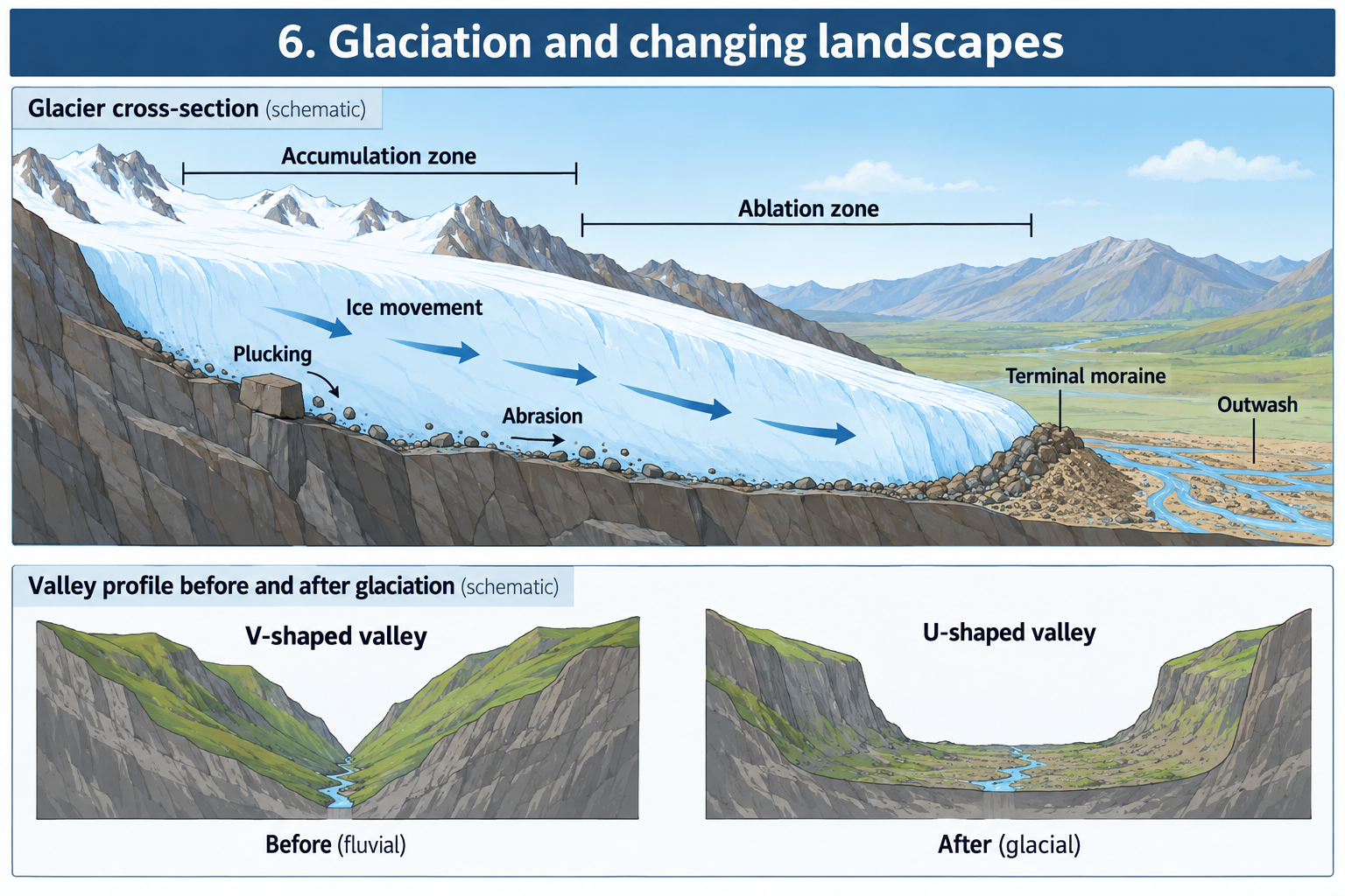
A glacier has a source region, a flow route and a lower edge. Snow accumulates high on a mountain. Ice moves away from thick areas under gravity and follows the ground. Lower down, melting and other forms of ablation remove mass. The lowest visible edge is the snout or terminus. It is not a fixed wall: ice can continue to arrive from upslope while its edge melts away.
Ice can flow
A small piece of freezer ice seems rigid. Under great pressure and over long periods, glacier ice deforms. Its crystals slowly change shape and slide relative to each other. This internal deformation is called creep. The glacier surface may crack where it is pulled apart, creating crevasses. Pressure is greater deeper in the ice, so behaviour can differ between the brittle surface and the lower ice.
Some glaciers also slide over the rock or sediment beneath them. Water may form at the base through melting, frictional heating or water travelling through cracks from the surface. Water can reduce friction, though the relationship between water pressure, the bed and movement is complex. The useful KS3 idea is that gravity moves a glacier downslope through internal deformation and, in some conditions, sliding at its base.
Different parts of a glacier do not necessarily move at the same speed. Ice may be slowed by friction against the bed and valley sides. In a simple valley glacier, central ice near the surface may move faster than ice near the wall. Patterns vary with shape, slope, temperature, water and the material beneath the ice. A diagram with arrows across the glacier is a simplified model, not a claim that every part travels at the same rate.
Accumulation and ablation
A glacier gains mass when snow or ice is added and retained. Snowfall is a major source; wind-blown snow and avalanches can also add material. A glacier loses mass when snow and ice are removed. Melting is important. Snow or ice can also turn directly into water vapour, be blown away or break into icebergs where a glacier reaches water. These loss processes are grouped as ablation.
The accumulation zone is where gains exceed losses over the period being considered. Snow left after summer can survive into another year. More snow falls on it; lower layers are compressed; air spaces shrink; snow grains recrystallise. Over time the material becomes firn and then dense glacier ice. The ablation zone is where losses exceed additions. The boundary between the broad zones is often called the equilibrium line for a particular year because annual gain and loss are approximately balanced there. Its position shifts with climate and weather.
Balance is tied to a time period. A glacier may lose mass in a warm summer, gain mass in a snowy winter, and still have a long-term trend of loss over many years. One season does not establish a lasting pattern. The equilibrium line can shift from year to year.
Mass balance and glacier change
A simple model is:
Mass balance = mass gained − mass lost
When gains exceed losses over a stated period, the balance is positive. The glacier may thicken or extend, although the snout may respond after a delay because ice takes time to move from higher slopes. When losses exceed gains, balance is negative and the glacier thins. Its edge may move uphill. When gains and losses are similar, it is close to balance for the period measured.
A glacier can advance when enough ice is supplied to its lower parts to outweigh losses there. It can retreat when melting removes ice faster than flow supplies it. This response can be delayed: an increase in snowfall at the top may take years to affect the lower edge, while a change in melting near the snout can appear sooner. Glacier size, slope and shape affect how quickly it responds.
The word retreat can be misleading. It describes movement of the glacier's boundary, not a reversal of ice movement. Ice can still flow downhill while the glacier's end shifts uphill because melting is faster than new ice arrives. An advancing glacier does not mean every part of the ice moves uphill; it means the ice-covered area expands.
2. How ice changes a landscape
Glaciers erode, transport and deposit material. These processes connect together. Rock is loosened and picked up; debris is moved within, on or below ice; some is ground into fine sediment; and material is left when ice melts or loses its carrying power. Meltwater may then carry and sort part of the load.
Weathering prepares rock
Weathering breaks down rock in place. It happens before, during and after glaciation. In cold mountains, water can enter cracks and freeze and thaw repeatedly. When it freezes it expands, placing stress on the sides of a crack. Repeated cycles can loosen rock blocks; this is freeze–thaw weathering. Gravity may move loosened material down a slope as rockfall or scree.
Weathered debris can collect near a cliff or on a glacier. Ice may carry it away, but weathering alone does not explain all glacial erosion. Distinguish rock loosened in place from rock removed by moving ice. Weathering makes material available; erosion removes it; transport moves it elsewhere.
Abrasion: debris scrapes the bed
Debris embedded in a glacier's base or sides can scrape the rock over which ice moves. This is abrasion. The debris acts like a file or sandpaper. It can smooth and polish exposed rock and cut scratches or grooves called striations. If former ice direction is known, striations may help reconstruct flow.
Abrasion needs more than ice. Debris must press against the bed and move. Fine material can grind a smoother surface; larger fragments can cut deeper grooves. Bedrock matters too: rocks vary in hardness, joints and resistance. Relatively clean ice moving over a bed with little debris may be less abrasive.
A polished surface is not automatic proof of glacial abrasion. Water, wind-blown sand and human activity can also smooth or scratch rock. Geographers look for a pattern: aligned striations, nearby glacial deposits, a plausible ice route and landform shape together make a stronger case than one mark.
Plucking: blocks are removed
Plucking happens when ice grips or freezes onto blocks of bedrock and carries them away. Existing joints and fractures provide edges that can be detached. Water in cracks, pressure changes and freezing can weaken rock. Moving ice may incorporate loosened blocks into its load, leaving a rough, quarried surface.
Abrasion grinds the surface using debris already carried in ice; plucking removes larger blocks from the bed and adds them to the load. Both may happen together. Plucking supplies new debris for abrasion, while abrasion and weathering expose fresh surfaces and fractures.
A roche moutonnée is often explained with both processes. In the simplified model, incoming ice presses against and abrades the upstream side of a bedrock knob, making it smoother. On the downstream side, pressure conditions and fractures may allow blocks to be plucked away, leaving a steeper and rougher face. This is a model; the history of a real rock knob can be more complicated.
Erosion reshapes valleys
Before a glacier arrives, rivers may already have cut valleys. A river often erodes most strongly near its channel. Over time a river valley often has sloping sides and a narrow floor, roughly V-shaped in cross-section. A thick glacier fills much more of a valley from side to side. It erodes floor and sides, widening and deepening parts of the pre-existing route. After the ice melts, a broad floor and steep sides may form a U-shaped valley, also called a glacial trough.
This is a comparison, not a rule that every river valley is a perfect V and every glacial valley a perfect U. Rock structure, river action, landslides and later erosion affect shape. A valley can look different at its head, middle and mouth, so read the location on a map or cross-section carefully.
Ice cutting across a projecting ridge can leave a truncated spur with a steep, blunt valley-side end. A sequence of truncated spurs on opposite sides may create a zigzag pattern in map view. Tributary glaciers are usually smaller than a main valley glacier and may erode less deeply, leaving hanging valleys above the main trough. A stream from a hanging valley can form a waterfall where it descends to the main valley floor.
Where ice excavates a deep basin, water may fill the hollow after melting. Some lake basins are over-deepened parts of troughs; others are partly dammed by sediment or bedrock. The existence of a lake alone does not establish how it formed. Consider basin shape, geology and deposits together.
Transport: where debris travels
A glacier carries debris in several positions. Material falling onto its surface from surrounding slopes is supraglacial. Material frozen within it is englacial. Material at the base is subglacial. At KS3 it is more important to understand that ice transports material than to memorise every term, but these labels help when reading diagrams.
A glacier's load may include clay-sized particles, sand, gravel, cobbles and boulders. A river often sorts much of its load by size as speed changes. Ice can carry a mixed load without sorting it in the same way. It can move material across a watershed that would normally divide river systems.
As debris is carried, fragments can collide and grind smaller. Fine rock flour may become suspended in meltwater. Some glacial lakes look cloudy or turquoise depending on sediment, minerals, depth and light. Colour is not a unique sign of glaciation: algae, dissolved minerals, weather and water depth also affect it.
Deposition by ice: till and moraines
When ice melts, it can leave debris that it carried. Sediment deposited directly by ice is often unsorted: small and large material can be mixed. This is called till. It can contain clay, sand, gravel and boulders without the layers sorted by a flowing river. Its composition depends on bedrock and sediment encountered along the glacier's route.
A moraine is a ridge or spread of sediment associated with a glacier. Position helps explain the former glacier:
- Lateral moraines accumulate along glacier sides, often from debris falling from valley walls or carried along the ice margins.
- Medial moraines can form where two glaciers meet and inner lateral moraines join.
- Terminal or end moraines mark a farthest former snout position or a place where the margin remained roughly still long enough for sediment to build.
- Recessional moraines can mark pauses during an overall retreat.
These names describe position and inferred history. Do not label a ridge by shape alone without checking its setting. A glacier can pause, readvance or retreat unevenly. Later streams, slope movement and people can reshape or partly remove moraines.
A terminal moraine can dam water and help form a lake behind it. Moraine material varies from place to place. A ridge may also be formed or altered by meltwater or slope failure, so maps, sediment exposures and its relationship to other features help establish its likely origin.
Deposition by meltwater: outwash
Meltwater flows away from ice carrying sediment. As it slows, it loses the ability to carry its largest particles first. Coarser material is usually deposited nearer the glacier; fine material can travel farther. A broad, relatively flat area of sand and gravel deposited beyond a glacier is an outwash plain. In a valley, meltwater may divide into braided streams that rejoin around sediment bars.
In a lake, fine particles may settle in layers through calmer water. Sorting can help geologists distinguish deposits moved by water from mixed sediment left directly by ice. A detached block of ice can be buried by sediment and later melt, leaving a depression called a kettle hole. If water fills it, it becomes a kettle lake or pond. Similar hollows can have other origins, so check evidence before naming one.
3. Landforms made by mountain glaciers
A mountain glacier can create a connected family of landforms. Erosion forms hollows at high elevations. Ice flows from them into valleys, widening and deepening the routes. Neighbouring glaciers cut ridges and summits. Downstream, sediment is deposited and meltwater reshapes it.
Corries, tarns and ridges
A corrie begins as a hollow on a mountain slope where snow accumulates. A slope facing away from strong sunshine may keep snow longer, and a hollow can trap wind-blown snow. Freeze–thaw weathering around the headwall supplies debris. A small mass of ice moves within the hollow, eroding its floor and back wall. Over a long period, the hollow can become larger and deeper, with a steep headwall and gentler basin floor.
After ice melts, water may fill a corrie to form a tarn. A tarn is common but not essential: some corries have no lake, and lakes can form in other kinds of basins. Basin shape and nearby landforms provide evidence; the water itself does not prove a corrie origin.
When corries develop on more than one side of a mountain, erosion can cut backwards toward the summit. A narrow ridge left between two hollows is an arête. If three or more corries cut toward a central summit, the peak may be sharpened into a pyramidal peak or horn. Rock strength, joints, slope aspect and glacier history affect the final shape.
Troughs and related features
A large glacier widens a valley into a trough. Its broad floor and steep sides contrast with the narrower shape of many river valleys. In map view, a trough may follow a straighter route than the winding river valley that existed before ice.
A truncated spur is a ridge cut off where ice moves across it, leaving a steep, blunt end. A hanging valley is a tributary trough left higher than the main trough because the main glacier was larger and eroded more deeply. A stream in the hanging valley may descend over a waterfall.
A ribbon lake is long and narrow and occupies an over-deepened section of a glacial trough. Ice may erode a deep valley section, while bedrock changes, sediment or a threshold help hold water in the basin. The term describes shape; not every long lake formed by precisely the same process.
These features often connect, but no single valley must display all of them. Its appearance reflects glacier size and duration, rock type, former valley shape, drainage and later erosion. A labelled diagram should explain the process without implying perfectly symmetrical sides.
Roche moutonnées and small clues
A roche moutonnée is a bedrock form shaped by moving ice. In the classic model, incoming ice smooths one side by abrasion and plucking makes the lee side steeper. A fieldworker can record surface smoothness, striation direction, joints and broken blocks.
Striations can preserve ice-flow evidence. They may be straight or curved; several directions may occur if an area experienced more than one phase. A group of marks is more useful than one scratch. Record compass bearing, map location, scale and rock type.
Small clues should connect to the broader landscape. A polished surface in a U-shaped valley beside an erratic and moraine supports a fuller explanation than one feature alone. Scale matters: a groove shows local movement while valley alignment can reflect a broader route.
4. Ice sheets, drumlins and retreating ice
Ice sheets cover broad areas rather than following only one valley. Flow direction can change, and pathways may converge or divide. Landforms left behind can be widespread in lowlands as well as mountains. They may be less dramatic than corries and peaks but still reveal former movement.
Drumlins
A drumlin is a smooth, elongated hill made mainly of glacial sediment, sometimes over a bedrock core. Groups form drumlin fields. Many are streamlined in the direction of ice movement. A simple model shows a blunt end facing incoming ice and a tapering end pointing down-ice.
Drumlin formation is complex and is not fully explained by one simple mechanism. Some form or are reshaped beneath moving ice; sediment and water at the bed matter. The KS3 idea is that drumlins are associated with moving ice and their alignment provides directional evidence. Do not infer direction from one hill without checking a wider pattern.
Erratics
An erratic is a rock whose type differs from its local bedrock and that has been transported from elsewhere, often by ice. Geologists compare its minerals and appearance with possible source rocks. A distinctive boulder among different local rocks may reveal former direction and distance of transport.
A large or unusual boulder is not automatically an erratic. It may have fallen from a nearby cliff, moved in a landslide or been placed by people. Compare its rock type with local geology, consider its shape and surface, inspect nearby sediment, and check whether a possible source lies along a plausible ice route. Distance should be based on source evidence, not guessed from appearance.
Moraines and retreat sequences
A glacier's margin may pause while climate continues to change. If it remains near one place, sediment may accumulate into a ridge. If the ice then retreats, the ridge remains. A sequence of ridges can show former margin positions. They are evidence about glacier behaviour, not an exact record of speed.
A moraine may be discontinuous; a stream or road may cut it. An outer ridge may mark former maximum extent, and smaller ridges farther up-valley may reflect pauses during retreat. Not every ridge represents one pause, and a landscape may include multiple glaciations. Describe what is observed, then explain an interpretation with caution.
Till, outwash and drainage
Till can blanket a lowland and make the surface uneven. Its mixed sizes are consistent with direct ice deposition. Meltwater may wash some sediment away and deposit sorted sand and gravel nearby. Outwash plains can extend from former ice margins, sometimes crossed by meltwater channels.
Ice can block a river route and force water elsewhere. After the ice melts, the river may not return to its former channel. Meltwater can cut new channels, deposit gravel or fill a lake with fine sediment. Modern drainage can therefore include routes inherited from glaciation. Later chapters explore rivers in detail; remember that ice and meltwater can both change where water flows.
Place example
5. The Lake District: a UK place example
The Lake District in north-west England connects landforms, rock and people. It is a mountainous region with radiating valleys, steep fells, lakes, and a long history of farming, settlement and visitor use. Its present landscape reflects nearly 500 million years of geological history, including changing seas, volcanic activity, uplift and erosion. Glaciers and meltwater later sculpted it. Ice did not create the rocks and mountains from nothing; it reshaped an inherited landscape.
The Lake District National Park describes smooth U-shaped valleys and steep, sharp ridges among its characteristic features. Its education resources use Wasdale as an example of mountain landscape. A broad valley floor lies below steep mountain slopes. This lets students discuss glacial trough shape, valley-floor land use and challenges of living or farming in upland terrain. High ground and ridges help show how ice interacted with bedrock and relief.
A map shows valleys and lakes radiating outward from a central upland. Many valley routes were occupied by ice and later by rivers and roads. Long, narrow lakes lie in some glacially modified valleys. Corries, ridges and steep-sided valleys occur, though each valley differs. Rock type, joints, glacier size and later modification help explain the variation.
The ice responsible for classic glacial landforms existed during cold phases of the Pleistocene. A broad classroom description is that the last major ice-age conditions in Britain ended around ten thousand years ago, but local retreat was not one instantaneous event. Different places became ice-free at different times; small glaciers or lasting snow patches could survive later in particular settings. Do not give a precise local melting date unless a source supports it for that place.
The National Park's special qualities describe the Lake District as a cultural landscape where narrow glaciated valleys, steep fells and slender lakes interact with a distinctive farming system. People have lived there for thousands of years. Dry-stone walls, farms, settlements, historic industries, roads and visitor infrastructure shape the landscape people experience today. Physical features influence human use; human decisions affect habitats, slopes, water and scenic qualities.
Reading the place as evidence
A strong place explanation combines evidence:
- A topographic map shows narrow lakes, steep valley sides, valley-floor width and valleys radiating from high ground.
- A cross-section compares a broad trough with a narrower river valley if scale and location are clear.
- A photograph may show a corrie, arête, spur or broad valley floor, but its angle can hide other evidence.
- A geological map shows bedrock differences that help explain why nearby valleys and slopes are not identical.
- Field notes can record striations, sediment, slope shape or moraine ridges; include location, scale and direction.
- A land-use map shows farms, roads, settlements, woodland, water and popular walking areas.
- A time series of photographs can show change, but the same viewpoint and comparable seasons improve the comparison.
One striking image may not explain a process. A photograph looking up a valley can make the sides appear symmetrical. A map shows a route but not its cross-section. A profile, photograph and map answer different questions; use them together.
Human use and management
The Lake District attracts walkers, climbers, cyclists, boat users, artists and other visitors. Tourism supports work in accommodation, food, transport, guiding and services. Residents and visitors may value scenery, access and recreation. Farming and local livelihoods maintain working landscapes and traditions. Reservoirs, roads and infrastructure have changed how people and water move.
These uses create pressures. Heavy footfall widens paths and exposes soil; rain can wash loosened material downhill. Parking and traffic affect narrow valleys and villages. Water sports and boats need access and may disturb wildlife or create conflicts. New buildings, signs and road improvements can affect views and habitats. Farming, tourism and conservation priorities do not always agree.
Management uses evidence to make choices. Path repair, stone pitching and drainage can reduce erosion by guiding walkers along a durable route. Visitors can be encouraged to follow paths, use public transport or avoid sensitive areas at some times. Conservation work can restore woodland, manage grazing, protect peat, maintain walls or monitor water quality. Each action has costs and limits: paths need maintenance; directing access may reduce pressure in one place but increase it elsewhere; tree planting can help habitats and water but must suit the site and preserve valued open landscapes.
Do not describe tourism as simply good or bad. Identify who benefits, who bears costs, where effects occur and how they could be managed. Visitors may bring income while increasing traffic on a narrow road. A footpath provides access while concentrating erosion. Residents, farmers, visitors, businesses and conservation groups may value the same landscape differently.
Maps, data and evidence
Cross-sections
A cross-section is a side-on slice through land. It compares valley shape along a chosen line. A U-shaped profile has a broad floor and steep sides; a V-shaped profile narrows toward the river. Include a title, location, labels and horizontal and vertical scales, or a note about exaggeration.
Vertical exaggeration makes slopes look steeper than they are. If the vertical scale shows fewer metres per centimetre than the horizontal scale, height is exaggerated. This helps reveal shape but is not a true view. Check scales when comparing profiles.
Contour maps
Contour lines join places at equal height. Closely spaced contours show steep slopes; widely spaced lines show gentle slopes. A contour map shows valley sides and floors, ridges, passes and basins. Read contour interval, scale, north arrow and map key.
A broad valley with a relatively flat floor and steep sides may suggest a glacial trough. A map alone cannot prove glaciation. Combine shape with deposits, geology and other landforms.
Photographs and diagrams
Establish where the photographer was, which direction the image faces and whether it has a scale. Identify shape, then separate observation from explanation. “The valley sides are steep” is an observation. “A glacier widened the valley” is an inference.
Diagrams are models. They show processes beneath ice that cannot be observed directly, but simplify shape, scale and sequence. Read titles, labels, arrows and keys. Ask whether an arrow shows ice flow, sediment movement, water flow or a sequence through time.
Sediment clues
Record the range of particle sizes and whether material is sorted, layered, rounded or angular. Mixed unsorted material may fit till; well-sorted layers may fit water movement. Sediment can be reworked after deposition, and local rock affects grain shape, so one clue rarely proves an origin.
A field sketch needs a title, date, location, direction, labels and a scale where possible. State which details are observed and which are interpretations. A photograph supports a sketch but does not replace an explanation.
Reconstructing former flow
Use several types of evidence:
- Record the orientation of striations.
- Compare blunt and tapered ends in a group of drumlins.
- Identify erratics and compare their rock type with possible sources.
- Map valley and sediment ridge alignments.
- Use moraines to estimate former margins.
- Check whether the proposed route fits slope and regional ice pattern.
- Compare clues and note disagreements.
Evidence can refer to different times. An earlier glacier may have moved in another direction; a river may have changed a channel after melting. The strongest conclusion explains most clues while acknowledging uncertainty.
7. Glaciation and timescales
Glacial landscapes record long-term change but also respond to shorter-term variation. Snowfall and temperature vary by season. A glacier margin may shift from year to year. A moraine can form over a longer period; a valley's broad shape records prolonged or repeated ice action. A modern landscape combines processes operating at different rates.
The Pleistocene Epoch included repeated colder and warmer conditions. During cold periods glaciers and ice sheets expanded; in warmer periods they retreated. The pattern differed among places. The last major glacial episode in Britain involved moving ice that altered mountain and lowland landscapes, followed by melting and drainage change. Lake District rocks and relief existed before the last glaciation.
The Holocene is the current epoch following the last major ice-age conditions. Since ice retreated from much of Britain, rivers, weathering, slope movement, vegetation, soils and human activity have continued to alter landforms. A glacial valley is not frozen in time. A river cuts its floor; rockfalls modify slopes; plants stabilise some ground; paths and roads alter its surface.
Glacial describes an important origin, not necessarily the only process shaping a feature today. The modern river in a trough did not necessarily make the trough wide. A lake may occupy an ice-eroded basin and receive sediment from tributaries. A stream can cut through a moraine. A valley floor can be farmed, built on or crossed by a road. Separate inherited form from present-day process.
Common misconception: 8. Frequent errors
A glacier is a stationary block of ice. Glacier ice deforms and flows under gravity. Its movement may be slow, but it can transport debris and change the land.
Retreat means every part flows uphill. Retreat describes a moving boundary. Ice can still flow downslope while melting shifts the snout uphill.
Abrasion and plucking are the same. Abrasion grinds rock with debris carried by ice. Plucking removes blocks from the bed.
All glacier valleys are perfect U shapes. Valley form depends on older relief, rock, ice size and duration, and later processes. U shape is a model, not a required template.
Glaciers only erode. They erode, transport and deposit. Meltwater transports and sorts sediment too.
Till and outwash are interchangeable. Till is deposited directly by ice and often unsorted. Outwash is carried by water and tends to be sorted.
Any ridge of stones is a moraine. Moraine is sediment associated with a glacier. Position and relation to the landform matter.
Every mountain lake is a tarn. A tarn is a lake in a corrie. Other lakes have other origins; use evidence.
The Lake District was made entirely by ice. Its rocks and relief reflect older geology. Ice reshaped them; rivers and people continued the work.
One clue proves an entire glacial history. Combine maps, landforms, sediment and geology. Consider other processes and multiple glacial phases.
A famous landscape has no people or trade-offs. The Lake District is a working cultural landscape where farming, tourism, transport, conservation and settlement interact with physical features.
Self-check: 9. Questions
Answer from memory first. For “explain” questions, connect process, landform and evidence.
- What makes a glacier different from a frozen lake?
- How can snow become glacier ice?
- What is the difference between accumulation and ablation?
- How can a glacier move downslope?
- What does negative mass balance mean?
- Why can a glacier retreat while ice still flows downhill?
- Describe abrasion and give one clue it may leave.
- Describe plucking and explain how it differs from abrasion.
- How can weathering supply debris for glacial erosion?
- What is till and how might it differ from outwash?
- What can a lateral moraine tell a geographer?
- How does a corrie form and what lake may occupy it?
- How can arêtes and pyramidal peaks form?
- Give two differences between a river valley and a glacial trough.
- What is a hanging valley and why might it have a waterfall?
- What is a truncated spur?
- How could a roche moutonnée record ice direction?
- What is a drumlin and how can a group help reconstruct flow?
- How could an erratic reveal where ice travelled?
- Why could a moraine and an outwash plain occur near one another?
- What evidence on a map may suggest a U-shaped valley?
- Why combine a photograph with a map or field notes?
- How does older geology matter when explaining the Lake District?
- Give a benefit and a pressure linked with tourism.
- Suggest a way to manage path erosion and name one limitation.
- Why use several clues to infer former ice movement?
- Explain why retreat does not mean that a glacier reverses direction.
- How might a river modify a glacial valley after the ice melts?
- Why is timescale important when describing mass balance?
- Write a chain linking snowfall, ice movement, erosion and deposition.
Suggested responses
- A glacier is persistent land ice that flows under its own weight; a frozen lake is water frozen in a basin.
- Snow survives melt seasons, accumulates, compresses, loses pore space and recrystallises into firn and dense ice.
- Accumulation adds snow or ice; ablation removes it through melting and other losses.
- Ice deforms internally under pressure and may slide over its bed; gravity moves it downslope.
- The glacier loses more mass than it gains over the measured period.
- Ice can continue down-valley, but if melting at the edge is faster than supply, the snout shifts uphill.
- Abrasion is grinding by debris at the ice base; it may leave polish, scratches or grooves.
- Plucking removes loosened bedrock blocks; abrasion grinds the surface with fragments already in the ice.
- Freeze–thaw can widen cracks and loosen blocks that the glacier picks up or grinds.
- Till is deposited directly by ice and often mixed and unsorted. Outwash is moved by meltwater and is commonly sorted as speed changes.
- It shows debris along a former glacier side and may help estimate route or margin.
- Snow and ice occupy a mountain hollow, weathering supplies debris and moving ice enlarges the basin. A tarn may fill it after melting.
- Corries erode backward from different sides. A ridge left between them can be an arête; several hollows can sharpen a summit into a horn.
- A trough is generally broader with a flatter floor and steeper sides; a river valley is often narrower and more V-shaped. These are general models.
- It is a tributary valley left above the main trough because its glacier eroded less deeply. Its river may fall to the main valley as a waterfall.
- A steep, blunt ridge end left where ice cuts across a projecting spur.
- The smoothed side faces incoming ice and the plucked side may face down-ice; check other evidence.
- An elongated hill of glacial sediment or sediment over rock. Aligned drumlins can suggest former ice-flow direction.
- Compare its rock type with local geology and possible source rocks, then map a plausible route.
- Ice leaves mixed debris at its margin; meltwater beyond the ice sorts and deposits material.
- A broad floor, steep sides and contour spacing may suggest a trough; cross-sections and other evidence improve confidence.
- A photograph shows shape, a map shows location and contours, and field notes record observations and scale.
- The rocks and relief pre-date the last ice. Glaciers reshaped them, so explain both inherited geology and glacial action.
- Tourism can support local jobs and services; heavy footfall can erode paths, increase traffic or disturb habitats.
- A drained, repaired path can reduce muddy widening. It costs money, needs maintenance and may affect access.
- Clues can be incomplete or reflect different periods. Agreement among striations, alignment, erratics and moraines strengthens an inference.
- Retreat is movement of the margin because of mass loss; ice can still flow downhill.
- A river can cut into the floor, move sediment, change channels or modify a lake basin.
- Gains and losses vary by season and year; a short measurement cannot establish a long-term trend.
- Persistent snow accumulates and compacts into ice; gravity moves it downslope; basal debris abrades and plucks rock; ice transports it and leaves till or moraine as it melts; meltwater sorts outwash.
10. Short practice tasks
Task A: Explain the chain
A student draws arrows from a corrie high on a mountain, down a valley and toward a moraine. Explain each stage. Include accumulation, ice movement, erosion, transport, deposition and evidence.
Model response: Snow accumulates in a sheltered hollow above the local snowline. If it survives summer and is compressed over many years, it becomes glacier ice. Gravity moves it out of the hollow and down the valley by internal deformation and sometimes basal sliding. Debris at the base abrades bedrock while plucking removes blocks from jointed rock. The glacier widens and deepens the route and carries its load downslope. When its margin pauses or melts, it can leave a ridge of mixed sediment called a moraine. Striations, valley cross-section and sediment provide evidence, though maps and field observations should be combined.
Task B: Compare deposits
Site X contains clay, sand, gravel and large angular boulders without clear layers. Site Y has layers of sand and gravel with smaller material farther from a former ice margin. Which site is more consistent with till and which with outwash? Explain and identify one limitation.
Model response: Site X fits till because direct ice deposits can mix many sizes without sorting them into layers. Site Y fits outwash because flowing water sorts sediment as its speed changes. Coarser material is deposited first and fine particles may travel farther. This is not proof: later rivers or slope movement may alter deposits, so their setting, grain shape and geological evidence matter too.
Task C: Evaluate a claim
“Every long lake in a mountain valley was made by a glacier.” Evaluate this statement.
Model response: A glacier can over-deepen a valley section and leave a long narrow basin that fills with water, so some mountain lakes are glacially influenced. However, shape alone does not prove glacial origin. Bedrock structure, landslide dams, moraines and later rivers can influence a basin. Check valley form, deposits, geological maps and local evidence. The claim is too absolute because it assumes one process explains every lake.
Task D: Stakeholder choices
A popular path crosses a steep, wet slope above a lake. The track has become broad and muddy. Suggest two management actions and compare who may benefit or be affected.
Model response: Drainage and stone pitching could make a defined route durable, reducing muddy widening and protecting vegetation. Walkers and conservation goals benefit, but the work costs money and materials must reach the remote site. Seasonal guidance or a temporary diversion could let vegetation recover, but may inconvenience visitors or move pressure elsewhere. A good choice uses monitoring, local views, cost, safety and habitat sensitivity.
Revision points: 11. Consolidation
- Use the sequence snow accumulation → compaction → ice flow → erosion and transport → melting → deposition and sorting by meltwater.
- Explain mass balance over a stated period; do not treat a glacier as stationary.
- Distinguish abrasion (grinding by debris) from plucking (removing blocks).
- Connect corries to tarns, arêtes and horns; connect troughs to hanging valleys and truncated spurs; connect moraines to former margins.
- Separate till from outwash and explain why they are sorted differently.
- Combine several clues to infer former flow direction or ice edge.
- Treat the Lake District as a place shaped by older geology, ice, meltwater, rivers and people.
- For human geography, compare benefits and pressures for different groups and assess choices.
- State what is observed, what is inferred and how confident the evidence makes you.
- Use a diagram, map or profile to support an explanation, not replace it with labels.
12. Guided enquiry: test a glacial landscape explanation
A geographical enquiry should start with a question that can be answered from evidence. For example: “How strongly does the shape of this valley support the interpretation that it was widened by glacial ice?” This is more useful than asking students simply to “find a U-shaped valley”, because it allows evidence to confirm, complicate or weaken the idea.
Choose evidence that answers the question
A map is useful for the valley's plan shape, contour pattern, tributaries and lakes. A cross-section compares the valley profile. A photograph shows visible slope and floor features. A field observation can record sediment, striations or the relationship between the valley side and floor. A geological map helps identify whether rock structure could influence the shape. Each dataset has limitations: a photograph has one viewpoint, a map may simplify detail, and a field observation samples only a small area.
Before collecting data, decide what will be recorded and how. For a cross-section, select a line across the valley and mark its end points on the map. For a field sketch, include direction of view, labels and scale. For a striation observation, record compass direction, the rock surface and whether several scratches share an orientation. For sediment, describe particle sizes and sorting rather than immediately naming an origin.
An illustrative profile comparison
The following values are made up for practice and are not measurements from a named valley. Two profiles are measured across valleys at the same map scale.
| Profile | Valley width at floor | Side slope | Cross-section description |
|---|---|---|---|
| A | 1.8 km | Mostly steep, with a broad floor | Wide trough-like profile |
| B | 0.3 km | Sloping sides meet close to a stream | Narrow V-like profile |
Profile A is more consistent with a broad glacial trough and Profile B with a narrower river valley. However, the measurements alone do not prove the origin. A broad valley might also reflect bedrock structure, landsliding or human modification. A robust conclusion would compare map shape, photographs, deposits and rock type and state how confident the evidence makes us.
When describing profile evidence, quote the comparison precisely: “Profile A has a floor 1.5 km wider than Profile B” is clearer than “A is much bigger.” Then interpret: “This wider floor is consistent with a valley widened by ice, especially if steep sides and nearby glacial deposits are also present.” Avoid jumping directly from a number to a cause.
Fieldwork method for sediment
If a teacher has selected a safe and suitable exposure, students can describe a small sediment sample without disturbing a protected feature. A simple observation sheet could ask:
- Is the material one particle size or a mixture?
- Is it arranged in visible layers?
- Are the larger pieces rounded, angular or mixed?
- Does the material appear to match nearby bedrock?
- Is the site close to a river channel, moraine ridge or former ice margin?
- What other explanation could account for the material?
A mixed range of sizes with little sorting fits direct deposition by ice, but it does not prove the deposit is till. A river may have reworked it; slope movement may have added material. Layering and sorting are consistent with transport by water, though later processes can modify a deposit. The observation should be written first and the interpretation second.
From observation to a supported conclusion
A useful conclusion has four parts:
- State the answer to the enquiry question.
- Quote two or more specific observations.
- Explain how each observation connects to a process.
- Identify a limitation or alternative explanation.
For example: “The valley evidence supports some glacial widening. The cross-section has steep sides and a floor wider than the nearby river profile, and the map shows a long, relatively straight trough. These shapes are consistent with a thick glacier widening a former river valley. The interpretation is stronger if moraine or striation evidence is also found. However, the profiles alone cannot show which process made each part of the valley, and rock structure may have influenced its width.”
13. Further questions for practice
These questions extend the self-check by asking you to compare evidence, explain sequences and evaluate decisions.
- A glacier receives more snowfall for three years, but its snout continues to retreat in the first year. Give two reasons this could happen.
- A rock face has parallel scratches, but there are no nearby moraines. What further evidence would you seek before concluding that a glacier made the scratches?
- A U-shaped valley contains a modern river. Explain how both ice and river processes may have shaped it at different times.
- A set of ridges crosses a valley at different distances from the mountains. Suggest what the pattern may show and give one reason to be cautious.
- A student says, “The glacier stopped moving when it reached the equilibrium line.” Explain the error.
- A boulder appears different from nearby rocks. Set out a short method for deciding whether it is an erratic.
- A map shows a waterfall at the mouth of a tributary valley. Explain how glaciation may have contributed to the height difference.
- A lake is held behind a ridge of sediment. What observations could help decide whether the ridge is a moraine?
- Explain why a large ice sheet can change drainage routes as well as valley shapes.
- A tourism business wants more car parking beside a popular lake, while residents are concerned about congestion. Identify information that would help planners compare options.
- Suggest how a geographer could use repeat photographs to study path erosion. Name two factors that should be kept similar.
- Explain why “glaciated” and “currently icy” do not mean the same thing.
- How might a moraine ridge affect settlement or transport today?
- What is the difference between a landform observation and a process explanation? Give one example of each.
- A valley contains till, a bedrock basin and an outwash deposit. Explain how these could be linked in a sequence.
Further suggested responses
- Ice takes time to flow from the accumulation zone to the snout, so increased snowfall may not immediately affect the terminus. The first year's melting may still exceed that year's gains, or the glacier may respond with a delay.
- Look for aligned striations in more than one location, a plausible ice-flow route, glacial deposits, a matching valley form and rock surfaces that show abrasion or plucking. Consider water or human tools as alternatives.
- A river may have formed a narrower valley before glaciation. A thick glacier later widened and deepened it. After melting, the river continues to erode the floor and move sediment but is too small to have made the whole broad trough.
- A series of cross-valley ridges may show former ice margins, including pauses during retreat. Their spacing does not provide a precise timetable; later streams, slope movement or more than one glacial phase may have altered them.
- The equilibrium line separates broad zones where annual gain or loss dominates. It is not a barrier or a point where ice becomes stationary. Ice can flow through it.
- Record the boulder's location and rock type; compare it with local bedrock and possible source rocks; examine surrounding deposits and shape; look for a plausible transport path; check whether people could have moved it.
- The main valley glacier may have been thicker and more erosive than a smaller tributary glacier. It cut the main trough more deeply, leaving the tributary floor suspended above it, where a waterfall can descend.
- Record the ridge's position relative to the lake and former valley, its continuity and shape, sediment mixture and connection with other glacial deposits. Compare these observations with meltwater or landslide alternatives.
- Ice may dam existing rivers, cover channels or direct meltwater through new routes. When ice melts, new channels and deposits can remain and the original river may not return to its former route.
- Useful information includes traffic counts at different times, parking occupancy, bus or walking access, resident and visitor views, habitat sensitivity, safety, local business needs and likely effects on water and paths. A comparison should include who benefits and who bears each cost.
- Take images from the same marked viewpoint and direction, ideally at a similar season and with a scale such as a fixed sign or ruler. Record date and weather. Compare path width, exposed soil, vegetation and drainage while noting that light, rainfall and camera position can change how the image looks.
- A glaciated landscape has evidence of former ice. It can be ice-free today while retaining valleys, deposits, scratches and ridges made by glaciers.
- A ridge can create uneven ground, constrain a road route or affect drainage. It may also be an archaeological or geological feature worth protecting. Local maps and field evidence are needed to understand its role.
- An observation describes visible evidence, such as “the valley floor is wide and flat”. An explanation links process and evidence, such as “the broad floor is consistent with widening by a valley glacier”.
- The glacier erodes bedrock into a basin and carries debris. As ice melts it leaves till, while meltwater carries and sorts some sediment farther away into outwash. Later water may fill the basin, and rivers can modify both deposits.
14. A short explanation checklist
Before submitting a longer answer, check that it does not skip the link between process and evidence.
- Have I identified the process precisely, for example abrasion rather than simply saying “erosion”?
- Have I explained what material is moving and where it is moving?
- Have I named the landform and described its shape or position?
- Have I used a place or map clue that supports the explanation?
- Have I separated observation from inference?
- Have I avoided absolute claims such as “all valleys” or “every lake”?
- Have I explained a human choice from more than one point of view?
- Have I stated timescale when describing change or mass balance?
- Have I noted a limitation when the evidence is incomplete?
A concise but complete explanation can be built in this order: “The process is… It moves or changes… This can create… Evidence here includes… This supports the explanation because… One limit is…” This structure helps organise reasoning; it should be adapted to the question instead of copied mechanically.
Curriculum alignment
- Curriculum coverage IDs:
ks3.physical.glaciation,ks3.physical.ice-age-to-present,ks3.human-physical-interaction - Related practice packs:
ks3_geography_glaciation,ks3_geography_glaciation_1,ks3_geography_glaciation_2,ks3_geography_glaciation_consolidated - Shared concept tags:
glaciation,landforms,weathering,landscape-change
Sources
- Curriculum/specification: Department for Education: England Geography programme of study
- Erosion and deposition: U.S. National Park Service: How Glaciers Change the Landscape
- Glacier formation and retreat: U.S. Geological Survey: Evaluating Glacier and Landscape Change
- Landforms: British Geological Survey: Landforms
- Regional geology: Lake District National Park: Geology and geomorphology
- Illustrative place study: Lake District National Park: Geography resources — mountain landscape
- People and cultural landscape: Lake District National Park: Special qualities
- Cryosphere vocabulary: National Snow and Ice Data Center: Cryosphere glossary
- These sources support general processes and the illustrative place example. For a local field study, verify detailed landform origins, dates and management decisions against the maps and sources used in class.