 FoxChild@Learn
9. Coasts and coastal change
Curriculum status: Required core content.
This England Key Stage 3 guide explains how waves, tides, rock structure, weathering, mass movement, erosion, transport and deposition shape coastlines. It links those processes to landforms and to decisions about coastal risk. Holderness and Spurn Point in East Yorkshire provide an illustrative UK example, not a case study every school is required to teach.
Coasts are active boundaries between land and sea. A beach, cliff, dune, saltmarsh or spit can change over hours, seasons and centuries. A useful explanation connects a process to a landform, checks the scale and direction of change, and identifies who benefits or faces costs when the coast is managed.
How to use this chapter
Start with the coastal system and its energy and sediment. Then trace how rock and sediment are weathered, eroded, transported and deposited. Use those processes to explain landforms. Finally, assess how people manage erosion and flooding along particular sections of coast.
When a question asks how a feature forms, write a sequence rather than a list of terms:
- Identify the starting condition, such as a joint in a cliff or sediment moving along a beach.
- Explain the process acting on it, such as hydraulic action or longshore drift.
- Show the change that follows, such as a cave enlarging into an arch.
- Link the process to evidence, location and timescale.
- Where people are affected, compare the options and their effects along the wider coastline.
Required knowledge
You should be able to:
- Explain how wind creates waves and how wave energy changes near a coast.
- Distinguish waves that tend to deposit sediment from waves that tend to erode it, while recognising that real coastlines experience a mixture of wave conditions.
- Describe how geology, rock structure, tides, exposure, weathering and mass movement influence coastal change.
- Explain hydraulic action, abrasion, attrition and solution as marine erosion processes.
- Describe traction, saltation, suspension, solution and longshore drift as ways sediment moves.
- Explain how erosion can form cliffs, wave-cut notches and platforms, headlands, bays, caves, arches, stacks and stumps.
- Explain how deposition can form beaches, spits, bars and coastal dunes.
- Interpret a map, photograph, beach profile, sediment sample or coastal change record.
- Compare hard engineering, beach nourishment, habitat restoration, managed realignment and planning.
- Use a named coastline as an example without assuming that one local process or policy applies everywhere.
- Explain why risk depends on the hazard, exposure and vulnerability, and why a defence does not remove every risk.
Key vocabulary
| Term | Meaning |
|---|---|
| Coast | The zone where land and sea interact; its boundary changes with tide, waves and erosion. |
| Wave | A movement of energy through water, commonly generated at the surface by wind. |
| Fetch | The distance over water across which wind blows to generate waves. |
| Swash | Water moving up a beach after a wave breaks. |
| Backwash | Water flowing back down a beach under gravity. |
| Constructive wave | A wave whose swash tends to be stronger than its backwash, encouraging deposition in suitable conditions. |
| Destructive wave | A wave whose backwash tends to be stronger than its swash, encouraging erosion in suitable conditions. |
| Hydraulic action | Erosion caused by water pressure and air compressed in cracks by waves. |
| Abrasion, corrasion | Wearing of a cliff, shore platform or bed by rock fragments carried by waves. |
| Attrition | Collisions that break sediment into smaller and often rounder fragments. |
| Solution, corrosion | Dissolving of soluble minerals in seawater or fresh water. |
| Weathering | Breakdown of rock in place, without the material first being moved away. |
| Mass movement | Downslope movement of rock or soil under gravity, such as a slump or rockfall. |
| Joint | A crack or fracture in rock along which movement has not necessarily occurred. |
| Bedding plane | A surface separating layers of sedimentary rock. |
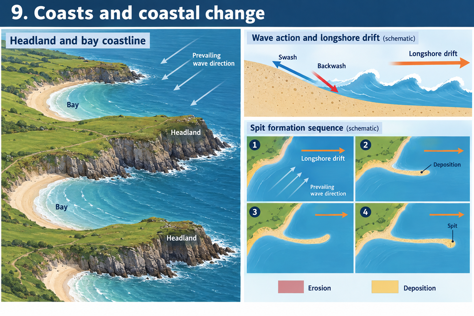
| Headland | A section of land projecting into the sea, often made of more resistant rock. |
| Bay | A curved inlet, often eroded more quickly where rock is less resistant. |
| Cave | A hollow enlarged into a cliff by erosion along a crack or weakness. |
| Arch | A passage through a headland formed when erosion joins openings or enlarges a cave through the rock. |
| Stack | An isolated pillar of rock left when an arch collapses. |
| Wave-cut notch | An indentation eroded at the base of a cliff near sea level. |
| Wave-cut platform | A gently sloping rock surface exposed as a cliff retreats. |
| Longshore drift | Movement of sediment alongshore as angled swash carries material up the beach and backwash returns it downslope. |
| Beach | An accumulation of sand, shingle or other sediment between the low-tide area and the land. |
| Spit | A narrow ridge of sand or shingle attached to land at one end and extending out into water. |
| Bar | A ridge of deposited sediment that extends across a bay or partly encloses an inlet. |
| Tombolo | A ridge of sediment joining an island to the mainland or another island. |
| Beach profile | A cross-section showing the slope and shape of a beach from its landward edge to the water. |
| Sediment cell | A length of coast considered as a system of sediment inputs, transfers, stores and outputs. |
| Groynes | Short structures built out from the shore to slow movement of sediment along a beach. |
| Sea wall | A strong barrier constructed along the coast to reduce wave attack or flooding at a frontage. |
| Rock armour | Large blocks placed on a shore or slope to absorb and dissipate wave energy. |
| Revetment | A facing or sloping structure placed on a bank or cliff to reduce erosion. |
| Beach nourishment | Adding sediment to a beach so it can absorb wave energy and provide a wider beach. |
| Managed realignment | Deliberately moving or changing a defended shoreline to create a more sustainable alignment, sometimes by allowing selected land to flood. |
| Hold the line | A Shoreline Management Plan approach to maintain or upgrade protection so the shoreline stays broadly in its current position. |
| No active intervention | A planned approach that does not invest in new or maintained defences along a particular unit, allowing natural processes to continue. |
| Advance the line | Building defences seawards to move the shoreline farther out. |
| Coastal erosion risk | The possibility of erosion causing harm to people, homes, infrastructure, land or heritage, given the people and assets exposed. |
How the geography works
A coastline is shaped by energy and sediment moving through a coastal system. Waves deliver energy; tides change water level and the part of the shore being attacked; wind and rivers supply sediment; geology controls how resistant the land is. Human actions can alter sediment supply, wave exposure and the places where people are vulnerable.
The amount of change depends on more than whether a wave is labelled constructive or destructive. Consider wave height, period, direction, storm history, the shape of the seabed, beach material, tide level and rock structure. One storm may shift a large amount of beach sediment; a calm period can allow some beaches to rebuild. A coastal photograph shows one moment, not the complete system.
1. Waves, tides and coastal energy
How wind creates waves
Wind transfers energy to the water surface through friction. Wave size is influenced by wind speed, how long it blows and fetch, the uninterrupted distance over water. Strong winds blowing across a long fetch for several hours can build larger waves than a gentle breeze over a short stretch of water. Local seabed shape, water depth and coast orientation then affect the waves that reach the shore.
A wave transports energy forward, but water particles mainly move in small orbital paths rather than travelling forward with the wave across the whole sea. As waves enter shallow water, the orbits are compressed, wave speed changes, and the wave may steepen and break. The resulting swash and backwash can move sediment and erode cliffs.
A storm does not affect every coast equally. An exposed coast facing the direction of large waves may receive more wave energy than a sheltered inlet. Headlands, islands, offshore banks and bays can also alter the amount and direction of energy that arrives.
Wave frequency and beach effects
A simplified KS3 comparison describes two common wave patterns:
- Constructive waves often arrive less frequently and with a stronger swash than backwash. They can move sediment up the beach and help build a berm.
- Destructive waves often arrive more frequently and have a stronger backwash than swash. They can pull sediment down the beach or offshore and expose the cliff foot to wave attack.
These labels describe typical effects rather than two permanent types of wave. The same beach can experience different conditions during a year. Storm waves may remove beach sediment, while calmer conditions allow it to return. Tides, sediment size, beach slope and wave direction affect the balance.
Swash, backwash and beach slope
When a wave breaks, swash pushes water and sediment up the beach. Gravity draws backwash down the slope. On a steep shingle beach, some water may infiltrate between the stones, reducing the amount of backwash at the surface. On a flatter beach, water may travel farther across the beach and return differently.
The repeated movement can sort sediment by size. Larger pebbles may be deposited higher on a beach under some conditions, while finer material can move more easily. The exact pattern varies with wave energy, tide, storms and local sediment. A beach profile surveyed after a storm may look different from one measured after a calm spell.
Tides and the intertidal zone
Tides are regular changes in sea level linked mainly to the gravitational effects of the Moon and Sun and the motion of the Earth. A high tide moves the zone of wave attack up a cliff or beach; a low tide may expose a wider shore platform. Spring tides have a larger tidal range than neap tides. The tidal range affects where waves can reach, the time available for fieldwork, access to beaches and the habitats that are exposed.
Waves and tides are related in their effects at the shore but are not the same process. A storm surge can raise coastal water above the predicted tide, increasing the chance that waves overtop defences or flood low-lying land. The actual water level at a site depends on tide, surge, wind, atmospheric pressure and local coastal shape.
Wave refraction around headlands
When a wave approaches an irregular coastline at an angle, the part of the wave entering shallower water first slows sooner. The wave front bends, or refracts. Energy can become concentrated around exposed headlands, while some bays are more sheltered. This can help explain why headlands are often more strongly eroded and why beaches may accumulate in bays.
Refraction does not make every headland erode at the same rate. Rock strength, joints, cliff height, beach cover and storm direction still matter. Use it as one process that can influence the spatial pattern of energy, not as a complete explanation on its own.
2. Coastal sediment and sediment cells
Where sediment comes from
Sediment on a beach may come from eroding cliffs, river inputs, offshore seabed material, shell fragments or sediment carried from another part of the coast. Waves and currents move that material between beaches, nearshore bars, dunes, estuaries and offshore stores. Some sediment can remain within a coastal system for a long time; some is carried beyond the area being studied.
A sediment budget compares inputs, transfers, stores and outputs. If inputs and transfers into a beach exceed losses, the beach may build up. If more sediment leaves than arrives, the beach may narrow. A sea wall does not create sediment, and a groyne does not stop the sea; each affects how sediment is stored or moved locally.
A sediment cell is a way of studying this connected movement along a stretch of coast. Cell boundaries can be headlands, estuaries, deep water or other features that limit exchange. These boundaries are not always perfectly closed. Sediment can cross them, especially during storms or where human structures change transport.
Longshore drift
Waves often approach a beach at an angle because of the prevailing wind and offshore wave direction. Swash carries sediment diagonally up the beach. Backwash returns under gravity at roughly right angles to the shoreline. Repeated movement can transport sediment along the coast in a zigzag pattern called longshore drift.
The direction and rate of drift vary. Wave approach changes around headlands and with storms; tides and currents may add movement in the nearshore zone. A single arrow on a map should therefore be labelled as the dominant or observed direction for a particular stretch and period, not a universal direction for every tide and season.
Longshore drift can move sediment away from an eroding cliff and supply beaches or depositional features farther along the coast. Where a harbour wall, groyne or other obstruction interrupts the movement, material may build on one side and less sediment may reach the other. The effect depends on structure design, transport direction, beach shape and replenishment.
Beach sediment and stores
A beach is a mobile store of sediment. It can absorb some wave energy and protect land behind it, but the amount of protection varies as the beach shape changes. Sand, shingle and mixed beaches behave differently because grain size, shape and permeability influence movement.
A wide beach may reduce the energy of waves reaching a cliff or sea wall. If storms remove material, wave attack can reach farther inland. Some sediment can return in calmer conditions; some may be transported to a bar, dune, estuary or deeper water. A survey should record tide and recent weather so that comparisons are fair.
Reading a coastal sediment budget
A simple budget might show:
| Part of the system | Example |
|---|---|
| Input | Eroding cliff adds sand, clay fragments or shingle to the shore. |
| Transfer | Longshore drift moves material along the coast. |
| Store | A beach, nearshore bar, dune or spit holds sediment temporarily. |
| Output | Material moves offshore, into an estuary or beyond the study boundary. |
| Human change | A groyne, harbour or nourishment scheme alters storage and transfer. |
This is a model. The amount of sediment in each part can change over a season or storm. A coastal map can show likely connections, while repeated beach profiles, aerial images and grain samples provide evidence about change.
3. Weathering, cliff instability and mass movement
Weathering in place
Weathering breaks rock down where it is, rather than transporting it away. It weakens cliffs and can prepare material for erosion or slope failure.
- Freeze-thaw weathering: water enters cracks, freezes and expands, widening the cracks over repeated cycles. Pieces may eventually fall from the cliff.
- Salt crystallisation: salty water enters pores or cracks. As water evaporates, salt crystals grow and can force grains apart.
- Chemical weathering: minerals react with water, oxygen or weak acids. Carbonate rocks such as limestone can be dissolved by slightly acidic water.
- Biological weathering: roots may widen joints; organisms can also break down or stabilise surfaces depending on conditions.
Weathering rates depend on rock type, exposure, moisture, temperature and the time available. A cliff can be weathered even when waves are not reaching its base.
Mass movement
Gravity can move weakened material down a cliff or slope. Types include rockfall, landslide, rotational slump and soil creep. A rockfall occurs when a fragment detaches and falls. A rotational slump moves material along a curved surface, often leaving a stepped or back-tilted surface.
Water can increase instability by adding weight, raising pore-water pressure or reducing friction between particles. Prolonged rain can saturate weak material; waves can remove support at the cliff toe. A cliff failure may happen suddenly after a long period of weakening. Coastal erosion is therefore not always gradual grain by grain.
A linked cliff-failure sequence
- Rain or weathering weakens material within a cliff.
- Groundwater enters fractures or saturates permeable layers above less permeable material.
- Waves remove material at the cliff foot and create an unsupported section.
- A block, slab or saturated mass moves downslope.
- The debris may protect the cliff temporarily or be removed by later waves.
- If the toe is cleared, a new section of cliff may be exposed to erosion.
The sequence varies by geology. Some cliffs are strong and jointed; others contain layered sands and clays that fail by slumping. A sea wall can reduce direct wave attack at the foot but cannot necessarily stop rainfall-driven landslides above it.
4. Marine erosion
Waves can erode a cliff directly and by using sediment as tools. Four processes are often distinguished.
Hydraulic action
Water is forced against rock and into joints and cracks. Air trapped in a crack can be compressed; repeated pressure can widen weaknesses. The strength of this process depends on wave energy, how exposed the rock is, crack structure and whether a beach absorbs some energy first.
Abrasion
Sand, pebbles and larger fragments carried by waves scrape or strike cliffs and shore platforms. This can wear down rock, deepen hollows and help shape a wave-cut notch. The sediment is the tool doing the abrasion.
Attrition
Fragments transported by waves collide with one another. Some edges break off, so particles can become smaller and rounder over time. Attrition acts on the sediment, not directly on the cliff, although rounded sediment can continue to abrade rock.
Solution
Some minerals dissolve in water. Solution is more important where the geology includes soluble material, such as limestone. It depends on mineral composition and water chemistry. Dissolved material is carried away in the water rather than remaining as visible grains.
How a cliff retreats
Waves erode a notch near the base of a cliff. The overhanging material can become unsupported and collapse. Weathering and mass movement may add material to the foot. Later waves can remove the debris, exposing the cliff again. Repeated cycles can make the cliff retreat inland and leave a gently sloping wave-cut platform.
A platform may be visible at low tide and covered at high tide. Its slope, width and rock surfaces provide clues, but one visit cannot show its rate of formation. Older raised platforms can record former sea levels or uplift, which is a different timescale and requires geological evidence.
5. How rock structure shapes headlands and bays
Differential erosion
Rock type and structure influence resistance. Harder rocks may erode more slowly than weaker rocks, while joints and faults can provide routes for water and waves. If bands of contrasting resistance meet the coast, erosion may create an irregular shoreline.
Where a resistant band projects seaward, it can form a headland. Softer rock may be eroded more quickly on either side, forming bays. Waves can refract around the headland and focus energy on exposed sections, while the bay may be more sheltered and accumulate beach sediment.
The pattern is not determined by rock strength alone. Bedding planes, joint spacing, dip, faulting, beach cover and wave direction all affect how a coast responds. Two headlands made of similar rock may have different shapes if their structures and exposure differ.
Geological maps and coastal cross-sections
A geological map shows rock units and structures at the surface or beneath superficial deposits. To use one, identify the coast, map key, scale, orientation and rock boundaries. A cross-section can help show whether rock layers are horizontal, tilted or folded toward the sea.
If rock layers meet the coast at different angles, a coast may develop a discordant pattern of alternating headlands and bays. Where rock bands run roughly parallel to the coast, a concordant coast may have a line of resistant rock protecting weaker material behind it; a breach can expose that weaker rock to erosion. These are useful models, but local structure must be checked rather than assumed from a label.
6. Erosional landforms
Caves, arches, stacks and stumps
A cave can form where waves exploit a joint, fault or weak band in a headland. Hydraulic action and abrasion enlarge the opening. If erosion cuts through the headland, an arch forms. The roof of the arch is weathered and undercut until it collapses. An isolated stack remains offshore; further erosion and weathering can lower it into a stump, often visible mainly at low tide.
The named sequence is not guaranteed at every coast. A cave may never become an arch if there is no throughgoing weakness. A stack may collapse unevenly or be dismantled by repeated wave attack. Sketch arrows showing wave attack and label each stage carefully.
Wave-cut notches and platforms
At the base of a cliff, waves can erode a notch around the level reached most often by energetic waves. As the notch grows, the cliff above can overhang. Collapse moves the cliff line inland. A gently sloping surface is left in front of the retreating cliff and can be exposed at low tide.
A beach may protect the base of a cliff by absorbing energy. If the beach narrows, waves may reach the cliff more often. Hard defences can protect land behind them but may alter the beach in front or the processes affecting nearby stretches.
Headlands and bays as an interacting system
A resistant headland may shelter a bay from some wave directions. Sediment can accumulate in the lower-energy water, building a beach. A change in storm direction can bring stronger waves into the bay, and currents can move sediment away. The landform and the beach are linked: a beach is not merely a decoration at the foot of a bay but a moving store that can protect the coast.
7. Depositional landforms
Deposition occurs when waves or currents lose energy, or when the amount of sediment exceeds the amount that can be carried away. The material may be deposited on a beach, in a sheltered bay, behind a headland, inside an estuary or along a dune system.
Beaches and beach profiles
A beach forms where sediment accumulates along the shore. Its shape changes with wave conditions, tides and sediment supply. A berm is a ridge or step often found on the upper beach after deposition. Offshore bars can store sand temporarily and may alter waves reaching the beach.
To compare beach profiles, choose a fixed transect and record the time, tide, weather and method. Measure elevation at regular intervals from a known baseline. Repeat surveys at comparable tidal states. A profile can show steepness and beach width; it cannot alone explain which process caused the shape.
Spits
A spit is a narrow ridge of deposited sediment attached to land at one end and extending into a bay or estuary. Longshore drift carries sediment along the coast. Where the shoreline changes direction or the coast is sheltered, wave energy may fall and sediment can accumulate out into the water.
The tip may curve if wave direction or tidal currents change. The sheltered water behind a spit may accumulate fine sediment and develop mudflat or saltmarsh. A spit can be breached during a storm, and it can migrate or change shape. Spurn Point at the mouth of the Humber is a UK example linked to sediment movement along the Holderness coast.
Bars and tombolos
A bar forms when a ridge of sediment extends across a bay or partly encloses a body of water. A lagoon may form behind it if the water is cut off from the sea, though tidal exchange can continue through openings. A tombolo is a ridge connecting an island to the mainland or another island. Sediment accumulation in the sheltered zone behind the island can help build the connection.
Do not call every long beach a bar or every spit a bar. Check whether the feature is attached at one end, extends across the bay or joins an island. A map and field view can help distinguish them.
Coastal dunes
Wind can carry dry sand inland from a beach. If an obstacle slows the wind, sand may collect and form embryo dunes. Plants such as marram grass can trap sand and help stabilise dune ridges, although trampling, storms, erosion and changing sediment supply can damage them. Dunes can act as a natural store and barrier, but they are dynamic habitats rather than fixed walls.
Place example
Holderness and Spurn Point, East Yorkshire
Holderness provides an illustrative example of soft-cliff erosion, sediment transfer and contrasting management choices. The East Riding coast includes glacial till, a mixed deposit of clay, silt, sand and pebbles left by ice. The Environment Agency’s Shoreline Management Plan Explorer describes the Holderness cliffs as about 60 kilometres long and made mainly of silts and clays, with local cliff heights ranging from low cliffs to higher sections. Its summary reports average erosion varying between about 1 and 4.5 metres per year along this stretch. These values are a broad description of a coast with strong local variation, not a rate that applies to every cliff or every year. The current East Riding coastal-change page identifies its monitoring figures as updated June 2026.
Waves attack weak glacial material. Rainfall and groundwater can destabilise cliffs, while storms remove material at the toe. Eroded sediment can be transported southward by longshore drift and contribute to beaches and the formation of Spurn Point. The Geological Society’s Yorkshire coast guide describes Spurn as a sand-and-shingle spit extending into the Humber mouth and links it to sediment moving south along Holderness. The exact size and outline of the spit can change, so use a dated map or image for current shape.
Mappleton as a management example
Mappleton is a defended frontage within a longer eroding coast. The East Riding Council describes the frontage as protected by a rock-armour revetment and rock groynes. Its monitoring guide explains that the 1991 defence scheme was designed to work with the beach: beach level is important because the beach absorbs wave energy in front of the structures.
The scheme can protect a selected village and associated infrastructure, but management decisions have a wider spatial context. A groyne can retain sediment on one side and reduce how much moves farther alongshore. If less sediment reaches a downdrift beach, that beach may narrow and expose cliffs to more wave attack. The Environment Agency’s assessment materials for the Flamborough Head to Gibraltar Point plan discuss possible beach narrowing and interruption of sediment transport near defended areas. Treat downdrift change as something to investigate with local monitoring, not as an automatic outcome at every structure.
To evaluate a defence, compare evidence from before and after construction and from more than one location. Useful evidence might include repeated beach profiles, dated aerial images, cliff-top surveys, maintenance records and the experiences of residents or businesses. Check that measurements use comparable locations, units and methods. A broad erosion average cannot predict when one particular cliff will fail, and a wider beach on one survey date may reflect a recent storm or tide rather than a lasting change. A defence can reduce one kind of risk while creating maintenance costs or changing sediment supply. The strongest explanation links the physical process to the place, then weighs protection, environmental effects and the people affected along the coast.
The local Shoreline Management Plan divides the coast into units and sets different approaches for different places. It does not mean every frontage is defended. The East Riding Council’s defence information explains that major settlements and selected infrastructure are defended, while defending the whole coast would be costly and could harm landscape or environment. The Environment Agency SMP Explorer records the current management context for Holderness; actions and policies may change as plans are reviewed.
Questions a geographer can ask about Holderness
- What geology lies behind the cliff, and how does it differ from a resistant chalk headland farther north?
- Which sections are defended and which allow more natural erosion?
- How does sediment move along the coast, and what evidence supports the direction?
- What happens to beaches near groynes, and what happens farther alongshore?
- Which people, infrastructure, habitats and heritage sites are exposed?
- How might a management decision change as risk and funding change over time?
- What can aerial photographs, beach profiles and council erosion surveys show?
The case is not “erosion is bad everywhere” or “defences are always good.” Erosion supplies sediment, reshapes habitats and can threaten homes or farmland. Decisions must weigh local protection against costs, environmental effects, sediment movement and adaptation.
9. Managing coastal erosion and flooding
Coastal management can reduce wave attack or flooding at a particular place, slow change, create space for natural processes, or help people adapt. A strategy should be assessed over time and along the connected coast, not only from the viewpoint of one protected property.
Hard engineering
Sea walls are built along the shore to reflect or absorb wave energy and protect a developed frontage. They can be effective where valuable settlements or infrastructure are concentrated. They cost money to build and maintain, may look out of place, can be overtopped, and reflected energy can scour material at their base.
Groynes extend from the beach toward the sea and can trap sediment moving alongshore. A wider beach may provide a buffer in front of a town. Groynes do not create sediment; they redistribute it and can leave less material to build beaches farther along the coast.
Rock armour uses large boulders at the base of a cliff or sea wall to absorb and dissipate wave energy. It can be quicker to install than a large wall, but rock must be sourced and transported, and the structure changes the natural appearance of the coast.
Revetments are sloping structures that reduce direct wave attack on a cliff or embankment. They need maintenance and may be damaged by storms. The slope can reduce wave energy, but the protected frontage remains dependent on the structure.
Offshore breakwaters reduce wave energy before it reaches the shore. Sediment can build in sheltered water behind them. They may affect currents, beaches and marine habitats, so the wider effects need modelling and monitoring.
Hard defences can lower risk to people and property while they function. They do not make a coast stable forever or remove flood risk during every storm.
Soft engineering and working with coastal processes
Beach nourishment adds sand or shingle to widen a beach. It can maintain a natural-looking buffer and support recreation, but sediment can be transported away and replenishment may need repeating. Sediment type should be suitable for the beach system.
Dune restoration can involve trapping sand, restoring vegetation and directing visitor access away from vulnerable sections. Dunes provide habitat and can store sand, but they can be damaged by storms or trampling. Fences and paths need maintenance.
Saltmarsh and mudflat restoration can create habitat and reduce wave energy in some settings. Effects vary with the width, vegetation, water depth and local wave climate. These habitats can erode as well as build, so projects need monitoring.
Managed realignment moves the line of defence landward in a planned way or allows selected low-lying land to flood. It can create intertidal habitat and space for water, but it may affect farms, homes, roads, ownership, livelihoods or historic features. Communities need time, information and fair processes to adapt.
Planning and adaptation can guide new development away from areas with future risk, support property relocation or roll-back, and improve evacuation planning. Planning does not move existing homes automatically and must consider community needs, services, land ownership and funding.
Shoreline Management Plan approaches
In England, Shoreline Management Plans (SMPs) provide a strategic approach for managing coastal flood and erosion risk along sections of coast. The Environment Agency describes four broad management approaches:
- Hold the line: maintain or upgrade defences to keep the shoreline broadly in its current position.
- Advance the line: build new defences to extend the land area seawards.
- Managed realignment: move the shoreline to a planned position, for example by allowing selected areas to flood or by creating habitat that helps manage risk.
- No active intervention: do not invest in new or maintained defences for a unit, allowing natural processes to continue while planning for the consequences.
An SMP policy is a planning direction, not a promise that funding is secured or work has been built. Policies can be reviewed as new data, environmental requirements, local strategies or funding conditions arise. The Environment Agency’s SMP guidance explains these approaches and links to the current SMP Explorer.
Choosing between strategies
Compare a proposed option by asking:
- What hazard is it designed to manage: erosion, tidal flooding, wave overtopping or more than one?
- Which people, property, infrastructure, habitats and heritage gain protection?
- What is the design life, maintenance need and cost?
- Could sediment movement or floodwater be affected elsewhere?
- What habitats or public access might be created or lost?
- Is the option adaptable if sea level, storms or land use change?
- Who makes the decision, and how are affected residents involved?
- What evidence could show whether the option is working?
There may be no single option that protects every place. A combination of defences, habitat restoration, monitoring, planning and relocation may be more sustainable than relying on one wall.
10. Coastal flooding, climate and risk
Coastal flooding can occur when high water levels, storm surges and waves overtop or breach a defence or natural barrier. Low-lying land behind a coast can also be flooded through estuaries or drainage channels. Erosion and flooding are related but different hazards: a cliff can retreat without the adjacent town being flooded, while a flood can occur on low land without a cliff collapsing.
Risk depends on the probability and physical characteristics of the event, exposure of people and assets, and vulnerability. A defended town may still face residual risk if a defence is overtopped or fails. A rural coast with few people may have high erosion but fewer immediate property losses; it may still have valuable farms, habitats, roads or heritage at risk.
Sea-level rise can increase the baseline water level from which tides and storm surges operate. The Environment Agency's current erosion information considers possible future scenarios and notes that wave climate, geology, ground instability, groundwater and sediment transfers also affect change. Projections are risk areas, not exact predictions of which individual property will be lost and when. Check the map title, assumptions, time period and whether it shows risk with or without planned management.
Climate change does not mean every stretch erodes faster by the same amount. Local rock, sediment, coastal orientation, defences, groundwater, tides, storms and land movement affect the result. A strong answer explains how a factor may change the hazard and then considers who is exposed.
Maps, data and evidence
Coastal maps and aerial images
Use a map to locate bays, headlands, beaches, cliffs, spits, estuaries, settlements, roads and defences. Check scale, north arrow, legend and date. A spit may appear to join the coast differently at different scales. Tidal flats and mudflats may be exposed at low tide but covered at high tide.
Aerial photographs can show changing cliff lines, beach width, groynes and development. Compare photographs taken at similar tide, season and viewpoint where possible. Image differences can result from viewpoint, shadow, vegetation, tide or storm timing as well as long-term erosion.
Measuring beach profiles
A beach profile records the slope from a fixed starting point down toward the water. A class may use ranging poles and a clinometer, or another supervised method approved by the teacher. Record the baseline, interval distances, angle or height, tide, date, weather and sediment type.
Repeat the profile along several transects and, if possible, on different dates. A single profile is a sample of one line at one time. The beach can change across short distances, and safe access depends on tide and conditions.
Measuring longshore sediment movement
To investigate movement, mark a safe observation point and record wave approach, swash direction, backwash direction and any visible movement of a suitable tracer. Use teacher-approved methods and permissions; do not release plastic, paint, or materials that could pollute a beach. A simple direction sketch is evidence of the observed conditions, not proof of annual net drift.
Repeated observations over different tides and weather conditions can reveal whether a direction persists. Compare notes with a map of the coastline and local wave exposure. At a curved coast, direction may change around a headland.
Measuring cliff retreat
Cliff retreat can be estimated by comparing a stable baseline with cliff-top positions on maps or aerial images taken at known dates. Field surveys may use measured control points, GPS equipment, or a surveyed profile under expert supervision. Students should never approach an unstable cliff edge to take a measurement.
Record the date, method, scale, uncertainty and exact section of coast. A mean rate over a long period can hide individual failures; one large slump can dominate a short record. Compare longer records and local geology before claiming that erosion is steady.
Reading a coastal management map
The Environment Agency’s coastal erosion map and SMP Explorer can show projected risk areas and planned approaches. Before interpreting a map, check:
- The time period shown.
- Whether projections include planned defences or assume no future work.
- The legend and categories.
- The shoreline unit and local management approach.
- Whether the map is guidance for areas or precise property-level prediction.
- The date of the data and whether the plan has changed.
A risk map supports a decision; it does not replace detailed site surveys, community knowledge or engineering evidence.
Common misconception
Waves carry the whole sea forward. Waves mainly transfer energy; water particles move in orbital paths, with net movement influenced by currents, tides and breaking-wave processes.
A constructive wave is always gentle and harmless. It describes a typical relationship between swash and backwash. Storms, tides and local conditions can still produce damaging waves.
All erosion happens at the cliff foot. Waves attack the base, but weathering, groundwater, rainfall and gravity can weaken or move material higher on the slope.
A stack always becomes a stump in a neat sequence. The sequence is a useful model; actual rock structure, collapse and wave conditions can change or interrupt it.
Longshore drift always moves in one fixed direction. Dominant movement depends on wave approach and local coast shape and can vary over time.
Groynes make new beach sediment. Groynes trap or redistribute material moving along the shore; they do not create it and may reduce supply farther alongshore.
Building a sea wall stops coastal change. A wall can protect a frontage, but it may need maintenance, be overtopped, affect the beach or leave residual risk.
Managed realignment means doing nothing. It is a planned change in the line of defence or a managed allowance of water onto selected land, usually supported by decisions about people, habitat and infrastructure.
An erosion projection shows the precise future cliff edge. It shows a risk zone based on assumptions and data. Local change can differ, so the map must be read with its time horizon and method.
A photograph proves a rate of retreat. A photograph shows an appearance from one date and viewpoint. Measuring change requires comparable images or surveyed positions at known dates.
Self-check
Answer from memory first. For longer questions, show the sequence of processes and use place evidence.
- What is fetch, and how can it affect wave size?
- How do constructive and destructive waves typically differ?
- How do swash and backwash move sediment?
- How do tides affect coastal fieldwork and wave attack?
- What is wave refraction?
- What is the difference between weathering and erosion?
- How do hydraulic action and abrasion differ?
- What happens during attrition?
- How can groundwater contribute to cliff instability?
- What is mass movement?
- What is longshore drift, and how does sediment move in a zigzag?
- What is a sediment cell?
- How can a cliff retreat and leave a wave-cut platform?
- How do geology and rock structure help form headlands and bays?
- Describe the sequence from cave to stack.
- How might a spit form at an estuary?
- How is a bar different from a spit?
- How can plants influence coastal dunes?
- What material makes up much of the Holderness cliffs?
- How is sediment from Holderness linked to Spurn Point?
- What are the four broad SMP management approaches?
- Give one advantage and one limitation of a sea wall.
- How can a groyne affect beaches on either side?
- What is beach nourishment?
- What may managed realignment achieve, and what conflict might it create?
- Why does a defended town still have some residual risk?
- What should you record when measuring a beach profile?
- Why should a cliff-retreat photograph be matched by date and viewpoint?
- What information should be checked before interpreting an erosion projection?
- Why can a coastal-management choice have different effects for different groups?
Suggested responses
- Fetch is the uninterrupted distance across water over which wind generates waves; longer fetch can allow larger waves if wind speed and duration are also sufficient.
- Constructive waves often have stronger swash and encourage deposition; destructive waves often have stronger backwash and encourage removal of sediment. These are typical patterns.
- Swash carries water and sediment up the beach, often at an angle; backwash returns downslope under gravity.
- Tide changes the shore zone reached by waves and the width of exposed beach. It affects access and the safe timing of surveys.
- It is the bending of wave fronts as parts of a wave slow at different rates in shallow water, changing where energy is concentrated.
- Weathering breaks rock down in place; erosion removes and transports material.
- Hydraulic action is pressure from moving water; abrasion is wearing by sediment carried by waves.
- Sediment particles collide and can break into smaller, rounder fragments.
- Water can add weight, raise pore pressure and reduce friction in weak material, making a slump or slide more likely.
- Downslope movement of rock or soil under gravity.
- Angled swash carries material up the beach and backwash returns it down the slope, producing net zigzag movement alongshore.
- A stretch of coast treated as a connected system of sediment inputs, transfers, stores and outputs.
- Waves erode a notch at the cliff foot; the overhang collapses; repeated retreat leaves a gently sloping platform in front.
- Contrasting resistance can lead weaker rock to erode into bays while stronger rock remains as headlands; joints and bedding influence the detail.
- A weakness is enlarged to form a cave; it may cut through to form an arch; collapse can leave a stack, which can later erode into a stump.
- Drift moves sediment alongshore; where the coast changes direction or water is sheltered, energy falls and sediment can build a ridge out into the estuary.
- A spit is attached at one end; a bar extends across a bay or partly encloses water.
- Plants can trap windblown sand and help stabilise dunes, but storms and trampling may damage them.
- Mainly soft glacial till containing clay, silt, sand and pebbles, according to the local geology and shoreline description.
- Sediment eroded from the cliffs may move southward by longshore drift and contribute to beaches and spit growth at Spurn.
- Hold the line, advance the line, managed realignment and no active intervention.
- A wall can protect a developed frontage; it is costly, may be overtopped or need maintenance and can affect the beach.
- It can trap sediment on one side and reduce the supply passing to another stretch; the scale and effect depend on local processes.
- Adding sediment to widen or restore a beach so it can absorb more wave energy.
- It can move the defence line, create habitat or provide space for water; it may affect homes, farms, roads, ownership or livelihoods.
- Defences can be overtopped or fail, and storms or instability can still cause harm.
- Record a fixed start point, distance, slope or height, tide, date, weather, sediment and method.
- Differences could come from angle, tide, season or shadow instead of true shoreline change.
- Time horizon, legend, assumptions about future defences, shoreline unit, date, scale and uncertainty.
- One group may gain protection while others experience cost, changed sediment supply, altered habitat, relocation or remaining risk.
Practice tasks
Task A: Explain a coastal landform
Describe how differential erosion can form a headland and bay. Include geological structure and wave energy.
Model response: If bands of rock with different resistance meet the coast, waves may erode the weaker band more quickly and form an inlet. More resistant rock remains projecting as a headland. Wave refraction can concentrate some wave energy around the exposed headland, while the bay may be more sheltered and store beach sediment. Joints, bedding and local wave direction affect the final shape, so the process should be checked against a geological map and coastal evidence.
Task B: Explain longshore drift and a spit
A map shows an estuary mouth and a ridge of sand attached to the northern bank. Explain one possible way it formed.
Model response: Waves approach the beach obliquely, so swash carries sand up the shore at an angle while backwash returns downslope under gravity. Repeated movement transfers sediment along the coast. Where the shoreline turns into the estuary or becomes more sheltered, wave energy can decrease and sediment may be deposited, extending a spit out into the water. Tidal currents and changes in wave direction can curve or alter its end.
Task C: Interpret a beach profile
After a storm, a profile survey finds a narrower beach than a survey from two months earlier. Give two possible explanations and one limitation.
Model response: Storm waves may have moved sediment offshore or alongshore, reducing the width at the transect. The surveys may also have been taken at different tides or after different recent conditions. One transect cannot represent a whole beach, and a short interval does not establish a long-term trend. Repeat profiles at several sites and record tide and weather.
Task D: Evaluate a proposed groyne
A town proposes a new groyne to keep sediment on its beach. Explain one benefit, one possible cost elsewhere and evidence needed to decide.
Model response: The groyne may trap sediment moving alongshore and help maintain a wider beach that absorbs wave energy in front of the town. It may reduce sediment reaching a downdrift stretch, where a narrower beach could expose the coast to more wave attack. Decision-makers should map sediment direction, compare beach profiles and monitoring data on both sides, estimate maintenance needs and consult affected communities before deciding.
Task E: Make a balanced coastal-management choice
A village has an eroding cliff, homes close to the edge and a protected wildlife habitat nearby. Compare a new defence with planned relocation or managed realignment.
Model response: A defence might slow erosion for homes and infrastructure, but it costs money, may affect sediment or habitat and would need approval and maintenance. Relocation or realignment can allow natural coastal change and create space for habitat, but it can disrupt residents, ownership, services and local identity. The decision should use current SMP policy, risk projections, ecological evidence and community views, and should say who gains, who carries costs and how the plan can adapt over time.
Revision points
- Explain fetch, wave energy, swash, backwash and tide separately.
- Treat constructive and destructive waves as common patterns whose effects depend on conditions.
- Distinguish weathering, erosion, transport, deposition and mass movement.
- Link rock type and structure to differential erosion, headlands and bays.
- Explain cave, arch, stack and stump as a sequence while noting that it can vary.
- Trace longshore drift with swash, backwash, sediment and net direction.
- Describe spits, bars, beaches and dunes with the conditions for deposition.
- Connect Holderness cliff material, erosion, sediment transfer and Spurn Point.
- Compare local protection with effects on nearby coasts, habitats and future adaptation.
- Interpret coastal maps, profiles and photographs with date, scale, tide, method and uncertainty.
Curriculum alignment
- Curriculum coverage IDs: ks3.physical.coasts, ks3.human-physical-interaction
- Related practice packs: ks3_geography_coasts, ks3_geography_coasts_waves_landforms_management
- Shared concept tags: coasts, erosion, deposition, coastal-management
Sources
- Curriculum: Department for Education: England Geography programme of study
- Coastal management policy and SMP approaches: Environment Agency: Shoreline management plans
- Coastal erosion, instability and climate: Environment Agency SMP Explorer: Coastal erosion and climate change
- Current erosion-risk map and limitations: Environment Agency: Check coastal erosion risk for an area in England
- Holderness coastline and monitoring: East Riding Council: Coastal change in the East Riding
- Holderness management context: Environment Agency SMP Explorer: Holderness Cliffs
- Mappleton and the defended coastline: East Riding Council: Defending the East Riding coastline
- Monitoring and beach-level design context: East Riding Coastal Explorer: Coastal Monitoring
- Spurn and longshore drift: Geological Society: By the sea, Yorkshire
- Coastal erosion and landforms: Geological Society: In the Sea
- Research on nature-based approaches: Environment Agency: Coastal and estuary management
- Use current local plans and surveys for project dates, costs and policies. Rates vary across the coast and over time; an average is not a prediction for a specific property.