 FoxChild@Learn
17. Water — school option
Curriculum status: Optional school choice. Choose one of food, water or energy for detailed study.
This guide follows AQA GCSE Geography 8035. Named examples below are suggested teaching examples where the specification allows a school choice; use your teacher’s selected case study and verify current figures before an assessment.
Required knowledge
- Explain global water surplus/deficit and rising demand.
- Explain how climate, geology, pollution, over-abstraction, infrastructure and poverty affect availability and insecurity.
- Assess supply schemes and sustainable management using a large-scale transfer and local LIC/NEE scheme.
Key vocabulary
| Term | Meaning |
|---|---|
| water stress | demand pressure relative to available supply |
| over-abstraction | withdrawal faster than replenishment |
| desalination | removing salts from seawater |
| grey water | gently used water reused for non-drinking purposes |
| water quality | suitability for a particular use |
How the geography works
Population, industry and agriculture increase demand. Climate variability and physical geography affect supply; pollution, ageing infrastructure, cost and unequal access can create insecurity even where water exists. Dams, reservoirs, transfers and desalination add supply, while conservation, recycling and groundwater management can reduce pressure.
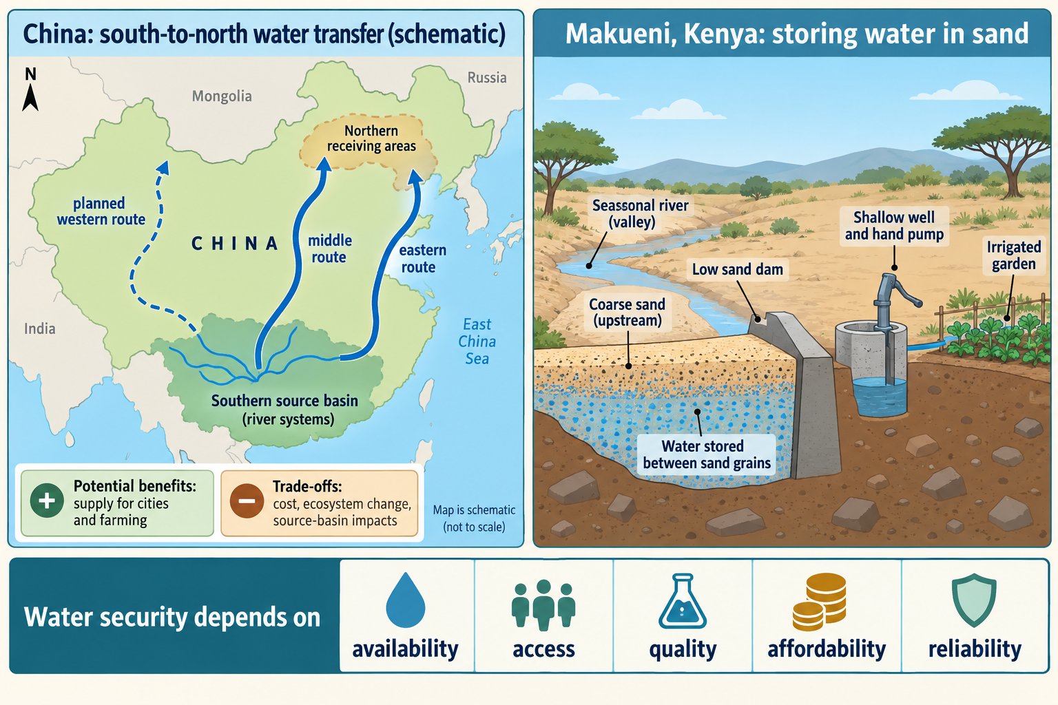
1. Water security: access to usable water at the right time
Water security means reliable access to enough safe, affordable water for households, livelihoods, economic activity and ecosystems. It depends on both quantity and quality. Water may be physically present but unusable because it is polluted, saline or inaccessible. A piped connection may exist but provide intermittent service. A river may carry water in one season and very little in another. Security also depends on whether supply continues through drought, flood, equipment failure or price shock.
Earth has abundant water, but most is saline and much freshwater is stored in ice or underground. The freshwater that is easiest to reach is unevenly distributed and continually moving through the hydrological cycle. Location, season, storage, treatment, infrastructure, governance and household income determine whether a community can use it. Water scarcity is therefore not just a map of rainfall.
Water-security dimensions
- Availability: Is enough freshwater present in a river, lake, reservoir or aquifer at the required season?
- Access: Can households, farms and firms reach a reliable supply through a nearby source or network?
- Quality: Is water safe and suitable for drinking, washing, irrigation, industry or ecosystems?
- Affordability: Can users pay for water and sanitation without sacrificing other basic needs?
- Reliability: Will the source and infrastructure function through dry seasons, pollution events and technical failure?
- Equity and sustainability: Are water rights and allocation fair, and can use continue without exhausting stores or damaging ecosystems?
The distinction between physical water scarcity and economic water scarcity is useful. Physical scarcity occurs when available water is limited relative to needs, including environmental flows. Economic scarcity occurs when water exists but investment, institutions, treatment, pipes, pumping or affordability prevent people from accessing it. The two can overlap: a dry region may have both limited supply and weak infrastructure.
The water cycle and stores
Water circulates through the atmosphere, land and oceans. Solar energy drives evaporation from seas, lakes, soils and vegetation. Transpiration moves water from plants to the atmosphere; together these transfers are often called evapotranspiration. Water vapour cools and condenses into clouds, then falls as precipitation. On land, water may be intercepted by vegetation, infiltrate soil, percolate into rock, flow over the surface, or move through rivers back to the sea.
Stores include oceans, ice, atmosphere, soil moisture, lakes, reservoirs, rivers and groundwater. Transfers include precipitation, infiltration, runoff, groundwater flow and evaporation. The quantity available to people depends on the store, its recharge rate, water quality and whether abstraction exceeds replenishment. An aquifer may hold water accumulated over many years; pumping it faster than recharge can lower the water table and raise the cost of pumping.
Water management modifies the cycle. A reservoir stores runoff; urban paving increases rapid surface runoff and limits infiltration; drainage moves water quickly through pipes; irrigation transfers water to crops; abstraction removes water from rivers or aquifers. Each action can change the timing and location of water, which may affect people downstream or ecosystems that depend on natural flows.
2. Global patterns of surplus and deficit
Rainfall is highly uneven. Equatorial areas often receive frequent heavy precipitation, while subtropical high-pressure zones contain many deserts. Monsoon regions have strongly seasonal rainfall; Mediterranean climates have dry summers; polar regions hold freshwater mainly as ice. Mountain ranges create orographic rainfall and rain shadows. These climate patterns give a broad global picture, but local water security also depends on geology, rivers, storage and demand.
Some regions have water surplus relative to population and economic demand during much of the year. Other regions have deficits because rainfall is low or variable, demand is concentrated, or available sources are polluted or difficult to access. A water-stress map may compare withdrawals with renewable supply, but it may not show quality, seasonal variation, local infrastructure or unequal household access. Check the specific measure and whether the map represents a year, a season or a modelled future scenario.
Demand increases
Population growth raises demand for drinking, cooking, washing and sanitation. Urbanisation concentrates users and requires large networks, treatment plants and storage. A growing city may draw water from distant reservoirs or river basins. If infrastructure investment lags behind population growth, households can face intermittent supply even where a bulk source exists.
Economic development can increase water demand in homes, manufacturing, energy generation, construction, mining and services. Higher incomes often support greater household consumption through appliances, gardens and leisure uses. Industry may require water for cooling, cleaning, processing or steam. Some power stations use water for cooling, although water requirements vary by technology.
Agriculture accounts for a major share of freshwater withdrawals worldwide. Irrigated farming can raise crop output but may intensify pressure on rivers and aquifers. Water is also embedded in food and goods through production, sometimes called virtual water. A country importing water-intensive crops can reduce local pressure, but transfer pressure to the producing region and rely on trade routes.
Factors affecting water availability
Climate: Rainfall amount, timing, reliability and temperature determine recharge, river flow and evaporation. Drought can reduce supply; intense rain may run off quickly rather than infiltrate, and floodwater can contaminate sources.
Geology: Permeable rock such as some sandstones can store groundwater; impermeable rock limits infiltration. Aquifer depth, porosity, fractures and water quality influence whether groundwater can be used. Coastal aquifers may face saltwater intrusion if abstraction is too high.
Pollution: Untreated sewage, agricultural fertilisers and pesticides, industrial chemicals, mining waste, oil spills, plastics and road runoff can lower water quality. Pollution reduces the usable supply and increases treatment costs. Water quality standards differ by use: irrigation water and drinking water do not have identical requirements.
Over-abstraction: Taking water faster than a river or aquifer can recover lowers flows and groundwater levels. This can dry wells, increase pumping costs, reduce wetland and river habitat, and contribute to land subsidence in some areas. Abstraction can be difficult to regulate when many users share a basin or when groundwater is not visible.
Infrastructure: Dams, treatment works, canals, reservoirs, pumps and pipes determine whether water can be stored, cleaned and distributed. Leakage, power cuts, poor maintenance and limited sanitation reduce the reliability of supply. Infrastructure can be expensive to construct and maintain, especially for dispersed rural settlements.
Poverty and governance: Households may be unable to pay connection charges, tariffs, water vendors or storage costs. A community may lack the political influence or institutional capacity to secure investment. Poor regulation or unclear water rights can allow pollution and unsustainable abstraction. Governance includes rules, accountability and participation, not just government ownership.
Water balance and catchment thinking
A water balance compares inputs and outputs from a defined system over a stated period. Precipitation is an input; evapotranspiration, runoff and abstraction are outputs or transfers out of the store. Storage changes as water enters and leaves soil, rivers, reservoirs and aquifers. A catchment with a positive balance over a wet season may still experience low flow in a dry season if water is not stored or if demand is concentrated then.
The catchment is a useful management scale because rainfall, runoff and rivers connect upstream and downstream places. Land cover affects how quickly water moves. Vegetated soils can intercept rainfall and encourage infiltration; compacted soil, roads and roofs may create rapid runoff. Wetlands can slow flows and store water; drainage and channel straightening can move it faster downstream. A local intervention can therefore have effects beyond its boundary.
Water availability also differs by time. Reservoirs can smooth seasonal variation, but storage levels may fall during consecutive dry years. Groundwater can provide a buffer, but recharge may be much slower than extraction. A transfer can balance supply between basins, but it still depends on source flows. A useful water-security analysis asks whether the source is replenished, whether water quality changes seasonally and how much is reserved for ecosystems.
Climate variability and future demand
Climate variability affects year-to-year rainfall, while climate change alters long-term averages and the probability of some extremes. A warmer atmosphere can increase evaporation and plant water demand. Changes in rainfall timing can affect reservoir recharge, soil moisture and river flow differently. Coastal areas may face saltwater intrusion as sea levels rise or groundwater pressure changes. The precise effect varies by basin, season, land use and adaptation.
Urban growth can add demand quickly when settlements expand faster than pipes, treatment works and wastewater systems. Informal or peri-urban growth may occur beyond planned service networks. Utilities may extend a network in phases, while households fill service gaps through vendors, wells, tankers or community systems. These arrangements affect price and quality and may shift risk onto people who are least able to pay.
Industrial change alters both the quantity and location of water use. New manufacturing, data processing, mining, construction and electricity generation may require water; service economies also depend on water in offices, hospitals, hotels and transport systems. Better technology can reduce water per unit of output, but total use may still increase as production grows. This is the difference between improving water-use efficiency and reducing the total volume withdrawn.
Virtual water links consumer demand to distant water use. A product’s water footprint estimates water used or polluted across its production chain. Importing a crop can mean the water used to grow it is embedded in trade. This can ease local pressure for the importer, but it may externalise demand to the producer. Water-footprint figures depend on crop, climate, irrigation, production method and accounting rules; use them to discuss relationships rather than as a fixed property of the product.
Water quality and pollution management
Water quality includes physical, chemical and biological characteristics. Sediment can increase turbidity; salt makes freshwater unsuitable for some uses; pathogens create health risks; excess nutrients can trigger algal growth and oxygen depletion; heavy metals and industrial chemicals may persist in water or sediments. Quality requirements depend on the use, but drinking-water safety needs especially strong treatment and monitoring.
Pollution can enter water from a single point, such as a pipe, or from diffuse sources across a landscape, such as fertiliser washed from many fields. Point-source pollution may be easier to locate, although not always easy to regulate. Diffuse runoff can be difficult to trace and control because it depends on rainfall, land management and multiple landowners. Sewage treatment, industrial permits, farm nutrient planning, riparian buffers, wetland restoration and public education can work together.
Pollution prevention is often less costly than treating contaminated water after it enters a river or aquifer. However, prevention requires monitoring and enforcement. Water suppliers need source protection, treatment works, testing and rapid response if contamination occurs. A clean-looking stream is not necessarily safe to drink from; some contaminants cannot be identified by sight or smell.
Water quality and water quantity interact. Lower river flows can make the same pollutant load more concentrated. Flooding can carry sewage, chemicals or sediment into wells. A dam or reservoir can alter temperature, flow and sediment, while a water transfer can introduce water of a different quality to the receiving system. Water treatment addresses specified contaminants but creates sludge and requires energy, chemicals and skilled operation.
3. Water insecurity and its impacts
Health and daily life
Unsafe water can transmit pathogens that cause diarrhoeal disease and other illness. Limited water can make it harder to wash hands, prepare food safely, clean homes or maintain sanitation. A water point far from a home adds time and physical effort to daily tasks; this time may reduce opportunities for school, paid work or care. The burden is often unevenly shared within households.
When piped supply is intermittent, households may store water in containers. Poorly covered storage can become contaminated or provide breeding sites for insects. Water vendors may supply a useful alternative but can charge more per litre than a subsidised network. A connection therefore does not fully describe security; continuity, quality, price and time to collect all matter.
Agriculture and food production
Water insecurity can reduce crop growth, livestock health and food processing. Drought lowers soil moisture and river flow; irrigation shortages may reduce yields just when crops are flowering or filling grain. Waterlogging and floods can also damage crops and contaminate stored food. If production falls across a region, market prices may rise, affecting households that buy rather than grow food.
Farmers may respond by changing crops, planting dates, irrigation methods or grazing patterns. Some responses are costly or unavailable to smallholders. Over-abstraction for irrigation can further reduce water available to households or ecosystems, creating conflict between uses. Water-efficient agriculture and better soil moisture management can help, but expansion of irrigated land may offset water saved per hectare.
Industry, energy and employment
Manufacturing may need water for processing, cooling and cleaning. Water shortages can interrupt production or raise operating costs. Energy systems can also depend on water: hydropower relies on river flow, and some thermal power plants need cooling water. Conversely, water pumping, treatment and desalination consume energy. The water–energy relationship means that a power shortage can interrupt water supply while a drought can affect electricity generation.
Industries may compete with households, farmers and ecosystems for supply. If a factory receives secure water while a nearby community does not, access raises questions about allocation and rights. Water-intensive firms can reduce use through recycling and efficient processes, but some residual discharge still requires treatment and monitoring.
Ecosystems and rivers
Rivers, wetlands and groundwater-dependent habitats need water at suitable times and quality. Excessive abstraction can reduce river flow, shrink wetlands and affect fish, plants and waterbirds. Dams can change sediment transport, seasonal flooding and the timing of flows. Pollution can cause eutrophication, toxic effects or low oxygen. Ecosystem damage may reduce services such as natural water filtration, flood storage, fisheries and recreation.
Water allocation therefore includes environmental flows—the quantity and timing needed to maintain river and wetland function. These needs can be contested when demand is high. Protecting environmental flows may limit short-term abstraction but support long-term water quality and resilience.
Conflict and cooperation
Where river basins cross borders, upstream dams, irrigation and pollution can affect downstream users. This creates potential for tension, but shared rivers can also encourage treaties, joint monitoring and cooperation. Conflict is not inevitable simply because water is scarce; institutions, power, alternative sources and political relations shape outcomes.
Conflict can occur within a country between cities, farms, industries, regions or communities. Drought may make competition more visible, but underlying issues can include unclear rights, unequal infrastructure, land use and weak participation. A careful answer identifies who is competing and the decision or flow at issue, rather than stating that “countries will fight over water.”
4. Strategies to increase water supply
Dams and reservoirs
A dam holds back river water to create a reservoir. Stored water can supply households and farms through drier periods, reduce some downstream flood peaks, support hydropower and create recreation. Reservoirs can improve reliability when rainfall is seasonal, but storage depends on catchment inflow and may decline during prolonged drought.
Construction requires capital, suitable geology and a large area. Land may be flooded, people may need resettlement and river ecosystems can change. Sediment trapped behind the dam can reduce reservoir capacity and deprive downstream floodplains or deltas of material. Evaporation is high from exposed reservoir surfaces in hot climates. Dams need safe operation, sediment management and maintenance over many decades.
Water transfers
A water transfer moves water from a source with greater supply towards a region with higher demand. It may use canals, tunnels, pipelines, pumping stations and storage reservoirs. Transfers can support cities, industry and farming, and can reduce dependence on local groundwater. They require energy, finance, engineering and agreements about allocation.
Risks include reduced source-region flows, ecological change, displacement, high costs, water-quality transfer, invasive species movement, evaporation and dependence on a long system that can fail. The destination may expand demand once new water arrives, so the transfer does not necessarily reduce total consumption. A transfer is a reallocation, not the creation of water; its sustainability depends on source-basin limits and demand management in the receiving region.
Desalination
Desalination removes dissolved salts from seawater or brackish water to produce freshwater. Reverse osmosis forces water through membranes; thermal methods evaporate water and then condense it. Desalination can offer a reliable coastal supply that is less dependent on rainfall, and may be valuable for cities with limited freshwater sources.
The process is energy intensive and can be costly. The concentrated brine left behind may affect marine ecosystems if discharged poorly; intake pipes can capture organisms; infrastructure and membranes require materials and maintenance. Desalinated water also needs distribution networks and treatment. Renewable energy can reduce operational emissions but does not remove the need to manage brine, cost and access.
Storage, groundwater and reuse
Small reservoirs, rainwater tanks and managed aquifer recharge can store water nearer to users. Groundwater is often naturally filtered and less exposed to evaporation than open water, but recharge may be slow. Pumping controls and monitoring help prevent depletion, saltwater intrusion and contamination.
Wastewater can be treated and reused for irrigation, industry, urban landscaping or, after advanced treatment and safeguards, some potable systems. Grey water is lightly used water from sinks, baths or showers that can be reused for suitable non-drinking purposes. Reuse can reduce demand on freshwater sources, but systems need separation, treatment standards, public trust and maintenance. Untreated wastewater reuse can create health risks.
5. Large-scale example: China’s South-to-North Water Diversion Project
Teaching example: China’s South-to-North Water Diversion Project is a possible AQA large-scale water-transfer case study. The project is phased and its routes do not all have the same status; use dated source information and any alternative case your school teaches.
Why a transfer was proposed
Water availability and demand vary substantially across China. The south contains the Yangtze basin and generally receives more precipitation, while northern regions include major cities, industry and intensive agriculture with high demand and greater water stress. Groundwater over-abstraction has been a concern in parts of the north. The project aims to move water from southern basins towards northern users and rebalance supply across regions.
The scheme was planned as three routes: eastern, middle and western. The eastern and middle routes began supplying water in 2014; the western route remains in planning, according to official updates. The middle route begins at the Danjiangkou Reservoir in Hubei and carries water north towards cities including Beijing. The route passes across river basins, using canals and aqueducts, tunnels and pipelines; water must be treated and connected to receiving distribution networks.
The eastern route uses parts of the Grand Canal and existing river infrastructure, with pumping needed to move water north. The middle route relies largely on gravity after water leaves the Danjiangkou Reservoir, although pumping and other engineered works are still needed across the wider network. The planned western route is more complex because it would cross mountainous areas and remains a proposal rather than an operating route. On an exam map, identify the status of each route and avoid drawing all three as completed.
The source and destination are separated by a large distance. A river-basin transfer therefore depends on agreements and monitoring across multiple provincial and municipal jurisdictions. Operators must manage volume, treatment, timing, storage and demand. A major project is also linked to local networks: water brought to a city only improves household security if treatment works and distribution pipes can supply neighbourhoods reliably and affordably.
Reported benefits
Chinese government reporting in December 2024 stated that more than 185 million people had directly benefited over the project’s first decade. It reported annual transfer volumes rising from over 2 billion cubic metres to around 10 billion cubic metres and described supply to 45 large and medium-sized cities. The same report stated that water had been used for ecological replenishment and that the scheme had helped curb declining groundwater levels in the north. Treat these as official reported figures and outcomes; they do not establish that every affected household has equal access or that all groundwater problems have been solved.
Potential benefits include more reliable municipal and industrial supply, reduced pressure on some northern aquifers, support for urban growth and better ability to manage seasonal shortages. Improved supply can benefit households and firms if water treatment, pipes and affordability keep pace. Water for ecological replenishment could support rivers or wetlands where reduced flows had caused stress. A transfer may also encourage planning at a basin or national scale rather than leaving each city to rely on local sources alone.
Costs and trade-offs
The project requires long canals, tunnels, pumping, reservoirs, treatment works and monitoring. Construction and operation demand large investment; water must be moved and treated over long distances. Costs may be reflected in public spending or water charges. The receiving region’s increased supply can support greater demand, so conservation and groundwater controls remain important.
The source basin also has users and ecosystems. Diverting water can affect downstream flows, especially if drought occurs in both source and destination regions. Water quality can vary along the route, and contamination in one part of a large system may affect other users. Large infrastructure can require land acquisition or resettlement, but the size and details vary by route and stage; use a specific verified example rather than assuming a single impact applies everywhere.
There is also a risk of treating water as an engineering problem alone. A transfer may be less costly than allowing severe scarcity, but demand reduction, leakage control, wastewater reuse, crop choice and pricing may be more sustainable for some users. If the source region becomes drier or demand continues to grow, a fixed transfer capacity may not provide long-term security. The strongest evaluation compares the project with alternative and complementary measures.
Stakeholders and scales in the China example
Receiving-city residents may value a more reliable municipal source, but affordability, service quality and local distribution determine household benefit. Industry and agriculture may gain from more dependable water, but can also increase consumption after supply expands. Source-region residents may be concerned about allocation and environmental flows. Provincial and national authorities coordinate construction, water rights and operation and may view the project as a way to support regional development. River ecosystems have no direct political voice, so environmental-flow rules and independent monitoring are important.
The effects operate at different scales: a household tap, a city’s water system, a province’s economic plans, a river basin’s flow and a national strategy. A city may gain security even if source communities face limits. A national total of transferred water does not show whether poorer households are served or whether rural wells recover. A robust evaluation compares the gains and costs at the same scales rather than using one national figure to judge all outcomes.
The project may also interact with other policies. Improving irrigation efficiency or changing crop patterns can reduce pressure on groundwater; reducing leakage can make more water available without increasing transfer volume; wastewater reuse can reduce demand for high-quality freshwater in some industrial processes. If these measures are absent, additional transfer water may support consumption growth instead of restoring groundwater. This is a possible rebound effect, not an inevitable result.
Judgement
China’s scheme demonstrates how engineering can redistribute water across a very large distance and support major urban and economic centres. Official reporting provides evidence of scale and reported beneficiaries. Its long-term success depends on source-basin sustainability, reliable operation, water quality, fair access, groundwater management and demand reduction. A transfer can improve security in the receiving regions while creating costs or constraints elsewhere; assess the full basin system rather than only the destination.
6. Sustainable water management
Water security can improve by managing demand and quality as well as building new supply. Conservation reduces unnecessary use through efficient appliances, leak repair, metering, water-sensitive gardens and changes in industrial processes. Conservation is most effective when users have practical alternatives and low-income households are protected from disproportionate costs.
Groundwater management tracks abstraction and recharge, protects recharge zones and establishes limits or shared rules. Groundwater can be a strategic reserve, but a monitoring system must measure how use affects levels and quality. Recycling and reuse reduce demand for freshwater and can keep water circulating locally. Grey-water systems can reuse suitable household water for toilet flushing or irrigation where plumbing, treatment and public-health safeguards allow.
Catchment management protects soils, wetlands and vegetation that influence infiltration, runoff and water quality. Restoring wetlands can slow flows and filter some pollutants; planting vegetation along riverbanks can reduce erosion; agricultural buffers can trap sediment and nutrients. These measures do not replace drinking-water treatment, and their effectiveness depends on scale, location and maintenance. They can provide multiple benefits, including biodiversity and flood management.
Pricing is one tool to signal scarcity and fund services, but water is an essential need. Increasing tariffs may encourage conservation while reducing access for poorer households. Lifeline tariffs, targeted support, public provision and transparent regulation can balance affordability and system costs. A strategy should distinguish essential household use from wasteful or high-volume demand.
Example of a local scheme in an LIC/NEE: Makueni County, Kenya
Teaching example: Makueni County in south-eastern Kenya is a possible local sustainable scheme. It has dryland communities and seasonal river channels; use a specific sand-dam or earth-dam project from your school’s case materials if required.
Local context and scheme design
Makueni lies in Kenya’s semi-arid south-east, where rainfall can be variable and seasonal watercourses may dry between rains. Households, livestock, farms and ecosystems depend on limited sources. In this context, water security is influenced by both supply and the distance, quality and reliability of access.
Sand dams are built across suitable seasonal sandy riverbeds. A barrier slows flow so sand accumulates; water is stored between coarse sand grains beneath the surface, reducing some open-water evaporation. Wells or pumps can draw water for household needs and small-scale agriculture. Site selection is important: catchment recharge, channel shape, geology, sediment and community water needs must be considered. A sand dam stores seasonal flow; it does not make rainfall or groundwater unlimited.
Makueni County reports that, in partnership with the Africa Sand Dam Foundation, it has constructed sand dams across several seasonal rivers and formed local sand-management committees. The County Sand Conservation and Utilization Authority describes water retention, natural filtration, reduced riverbed erosion and riparian agribusiness among the benefits it seeks to support. These are county-reported programme claims; independent or continuing monitoring is needed to measure water quality, recharge and household outcomes at each site.
At a sand dam, the structure does not usually form a deep open reservoir. Seasonal flow carries sand and water down a channel; after the barrier is built, coarser sand accumulates behind it and holds water between grains. This subsurface store can lose less water directly to evaporation than a broad shallow pond. Users may draw from a shallow well at the riverbed or a protected intake, then carry water or use a pump. Some sites add tanks, pipes and kiosks to move treated water to homes. The exact arrangement differs by project; a diagram should label only features present at the named site.
Where water is used for crops, small plots may grow vegetables or fruit that diversify household diets and provide a surplus for sale. Crop choice matters: a water-intensive crop could undermine the purpose if it uses too much of the stored supply. Drip irrigation, mulching and soil cover can reduce some losses, but access to equipment and training influences whether farmers can use them. Water rules need to balance household drinking and sanitation, livestock, irrigation and environmental needs.
Another project, Uyi Earth Dam, was rehabilitated through county and national-government collaboration. In March 2025, the county reported a treatment plant, solar-powered pumping, distribution network and access improvements for residents, alongside water for livestock and micro-irrigation. It reported 7,800 residents as intended beneficiaries and described a larger storage expansion as a future commitment. Separate project reports can count beneficiaries and capacity differently; treat the numbers as project-reported and keep planned works distinct from completed components.
Potential benefits
- Storing seasonal runoff can make water available for longer into a dry period.
- A nearby source can reduce the time and effort required for water collection.
- Treated and distributed water can improve household health and reduce reliance on unsafe sources.
- Small-scale irrigation can support vegetables, household food and limited market sales.
- Water for livestock can reduce animal losses and support pastoral livelihoods.
- Solar-powered pumping can reduce dependence on diesel or unreliable grid supply where the system is maintained.
- Community management and county partnerships can build participation and local knowledge.
Limitations and trade-offs
A small local scheme serves a limited area and cannot solve water insecurity across all of Kenya. Sand-dam sites must be suitable, and drought can reduce recharge. Earth dams can lose capacity through sedimentation and need desilting and repairs. Pumps, solar panels, treatment systems, pipes and kiosks require maintenance, spare parts and trained operators. Water quality still needs testing and household handling must remain safe.
Water used for irrigation or livestock must be balanced against household needs and downstream ecological flows. Poor allocation can create conflict or favour landowners with pumps over people without land. Additional irrigation can increase water use and may add soil salinity or erosion if drainage and land management are poor. A sustainable design needs inclusive rules, monitoring, finance and a way to repair the system after a project ends.
Evaluation
Makueni’s approach is locally adapted because it stores seasonal flow and combines water access with agriculture and community-level management. It may be more accessible than a distant transfer for particular villages and can provide several benefits from one project. Its scale, recharge, water quality and maintenance limit how far it can be replicated. Assess the evidence at the named site: was the infrastructure completed; how many households use it; is supply dependable through a dry season; who can afford and access water; and are river and groundwater conditions monitored?
County project information is valuable for location, design and stated objectives, but it is not a complete independent evaluation. A source may report that infrastructure was commissioned or that residents are expected to benefit; this does not automatically show a sustained change in water quality, time saved or household income. To test outcomes, compare baseline and follow-up data and identify the measurement method. Ask whether the indicator counts registered beneficiaries or active users, and whether the figure includes the whole scheme or only one component.
If a community helps choose a site and contributes labour or rules for water sharing, local ownership may improve maintenance and legitimacy. It can also place unpaid labour burdens on residents. Participation should be meaningful, with women, poorer households, people with disabilities and downstream users involved in decisions. A water point can be physically close but inaccessible to someone who cannot safely reach it or operate its pump. Equity includes design and governance, not just total litres stored.
Water management at more than one scale
Integrated water-resources management coordinates land, water and related resources across a catchment, while considering social and economic needs and ecosystem health. In practice, agencies may be responsible for different tasks: water utilities supply households, environmental bodies manage river quality, agriculture departments advise farmers, and local authorities plan land use and drainage. If organisations do not share information, one policy can undermine another. For instance, a new housing area can increase water demand while reducing infiltration and increasing runoff.
Catchment partnerships can coordinate monitoring, pollution prevention, flood management, abstraction rules and habitat restoration. They can bring together regulators, utilities, farmers, residents and businesses, although power and resources are not automatically equal. A partnership needs clear targets, transparent data and enforcement where voluntary action is insufficient. Integrated management is a process for making connected decisions, not a guarantee that conflicts disappear.
Demand-side measures
Demand management lowers pressure on supplies by changing how much water is used, when it is used or how much is lost. Households can install efficient toilets and appliances, fix leaks, use rainwater for gardens and avoid unnecessary outdoor watering. Water companies can reduce leakage, improve metering and plan networks for drought. Farms can schedule irrigation against soil moisture and crop need, adopt drip systems where suitable, improve soil structure and select varieties that need less water. Industries can reuse process water or redesign production.
Efficiency should be measured at more than one scale. If a drip system uses less water per hectare but encourages expansion of irrigated fields, basin withdrawals may not decline. If more efficient appliances lower water bills, households may use the savings for other water-consuming activities. This does not mean efficiency is useless; it means total abstraction and ecological flows should be monitored as well as the efficiency of each device.
Leakage repair can be cost-effective where losses are large, but underground leaks are difficult to locate and repairs may disrupt roads and services. Metering can reveal high use and help plan investment; it can also create hardship if prices are not designed to protect essential household needs. Tariffs can encourage conservation and fund treatment, but water is necessary for health. A fair policy may combine a basic affordable allowance, progressive charges for high volumes and public investment for households unable to pay connection costs.
Drought planning and adaptive management
Drought plans identify how supply will be managed as reservoirs fall or river flows decline. Measures may be phased: public information and voluntary conservation, temporary restrictions on non-essential use, alternative supplies, emergency tankers, and prioritisation of essential services. Farmers may need advance notice to change planting or livestock decisions. Ecological flow limits should be defined before a crisis, because emergency abstraction can otherwise damage rivers at the moment they are most vulnerable.
Early-warning systems combine rainfall, soil moisture, river flow, reservoir levels, groundwater, crop conditions and climate forecasts. Forecast uncertainty should be communicated clearly. A warning is useful only if households, farmers and agencies can act on it; that requires trusted information, practical alternatives and coordination. After a drought, review who received water, which sources failed, how quickly services recovered and whether emergency decisions made future risk better or worse.
Adaptive management changes rules as monitoring evidence improves. Abstraction permits may need seasonal limits; reservoir operating rules may need to balance supply, flood storage and ecosystem flows; transfer volumes may need adjustment. Monitoring should include both quantity and quality and should be accessible to affected users. Community observations can complement instruments, especially where formal monitoring stations are sparse.
Planning for future supply and demand
Water planners estimate future conditions by combining population projections, expected household use, industrial plans, agricultural demand, leakage, climate scenarios and environmental-flow requirements. Each estimate has uncertainty. A city’s population can grow faster or slower than expected; water-efficient appliances can reduce use; a drought sequence can be more severe than the historical record. Planning only for the average year can leave a system vulnerable to extremes.
Scenario planning compares different possible futures—for example, higher population with warmer, drier summers; moderate growth with strong conservation; or continued demand with a major new transfer. Planners can then identify options that remain useful across several scenarios, such as leakage repair, catchment protection and flexible operating rules. This is sometimes called a no-regrets approach, although a measure still has costs and should be assessed for who pays and benefits.
Water resilience can be tracked through indicators such as days of stored supply, frequency of service interruption, river flows, groundwater levels, water-quality failures, leakage rates and affordability. No single measure captures the whole picture. Reservoir capacity may look secure while a network loses water; a treatment plant may meet quality standards while low-income homes remain unconnected. Pair system indicators with household and ecosystem outcomes.
Assessing the two scales of example
China’s transfer demonstrates a national-scale redistribution of water supported by large engineering works and state coordination. Makueni’s local schemes use storage and distribution at a smaller scale and depend on seasonal recharge, site suitability and local maintenance. A large scheme may supply cities and industry but has a wide footprint and long route. A local scheme can directly address one community’s access but serves fewer users and remains exposed to local drought.
Neither scale is automatically more sustainable. A national transfer can be justified if it operates within source-basin limits, supports equitable access and is paired with demand controls. A local system can be justified if it has reliable recharge, safe water, inclusive governance and a maintenance plan. The comparison should identify the specific need, the users served and the evidence showing results. A country might use both approaches alongside conservation and pollution control.
7. Compare water-management strategies
| Strategy | Scale and mechanism | Strength | Limitation to assess |
|---|---|---|---|
| Reservoir or dam | Stores surface water for later release | Can supply cities, irrigation and sometimes hydropower | Land, ecological flow, sediment, displacement and evaporation |
| Inter-basin transfer | Moves water between regions | Can connect surplus and deficit areas | Expensive, energy-dependent and may reduce source-basin flow |
| Desalination | Removes salt from seawater or brackish water | Reliable coastal source less dependent on rainfall | Energy use, brine, cost, intake and distribution |
| Groundwater management | Controls abstraction and protects recharge | Provides distributed storage and often stable supply | Aquifers can be depleted or polluted, sometimes invisibly |
| Wastewater reuse | Treats water for another use | Reduces demand on freshwater and can be local | Treatment, health safeguards, public acceptance and maintenance |
| Leakage repair | Reduces losses from distribution networks | Often avoids impacts of a new source | Repairs need investment, time and continuous monitoring |
| Conservation | Reduces demand per person or process | Can improve security without moving water | Requires behaviour change, alternatives and equitable rules |
No one strategy is best for every location. A city on a dry coast may consider desalination, while a rural community with suitable seasonal channels may benefit from local storage. A river basin with high leakage may gain more from repairs than from another dam. Consider environmental limits, costs, reliability, social access and the time needed to deliver each option.
8. Map and data skills for water questions
Read a water-stress map by checking what the ratio compares. Some indicators divide withdrawals by renewable water supply; others include seasonal variation, environmental flows or access. A single national colour hides differences between cities, rural areas and river basins. Use the map to identify a pattern, then explain it with climate, demand, infrastructure or water quality evidence.
On a river-basin map, identify the source, route, receiving area and downstream communities. For a transfer, label the direction of flow, source basin, crossing points, reservoirs and end users. Do not assume that a line on a map shows actual delivery to every household. For a chart, state the units and period: cubic metres per year, litres per person per day, proportion with access, or reservoir capacity measure different things.
If comparing years, identify whether a change is absolute or percentage. A rise in total water use can occur because population grew even if per-person use fell. A decline in groundwater level can be affected by rainfall as well as pumping. Do not claim that a single project caused a change unless evidence supports causation.
Worked data drill (illustrative values only)
Imagine a question gives two regions. Region A receives 1,200 mm of rainfall each year and withdraws 30% of its renewable supply. Region B receives 450 mm and withdraws 70%. These values are invented for practice and do not describe real countries. A first inference is that Region B has greater pressure relative to its renewable supply. Explain why: lower rainfall limits recharge while withdrawals use a larger proportion of what is renewed. A second inference might be that B is more exposed to drought, but this needs seasonal data, storage and alternative sources before it is established.
Now imagine that 95% of people in A and 65% in B have a household water connection. This suggests a difference in network reach, but not necessarily drinking-water safety or continuity. A might have extensive networks with pollution problems; B might have community wells that the connection statistic does not count. Read the indicator definition before interpreting the gap.
Suppose a transfer option could raise B’s reported access to 85%, while a leakage-repair programme could raise it to 78% at lower cost. The transfer may benefit more people, but its source region and environmental flow need assessment. Leakage repair may deliver more quickly, but cannot expand supply if the network is already efficient or the pipe damage is limited. Compare who is reached, how reliable the change is, what the source impact is and whether the figures include costs.
Finally, state a conditional judgement: “The transfer would be more effective for rapidly extending supply if the source basin has reliable surplus and the receiving network can deliver safe, affordable water. If the source flow is already under stress, repairs, reuse and demand management may be more sustainable.” This conclusion shows how the evidence and uncertainty shape the decision.
Use maps to identify people and places at risk
An area-level map can identify a region with low rainfall or high withdrawals, but risk is experienced by people and ecosystems at specific places. Overlaying settlement, farming, rivers, aquifers and infrastructure can show who is exposed. A rural community far from a piped network may face different constraints from a low-income urban neighbourhood where the network is intermittent. A downstream wetland may experience reduced flow even if city users receive a reliable supply.
GIS can combine layers such as population density, water points, flood zones, water quality, land use and road access. Each layer has a date, resolution and measurement error. A water point shown on a map may be broken or seasonal; a census population may be several years old; a pollution sample may represent one date. Mapping is powerful because it reveals spatial relationships, but map layers need field checks and context.
9. Answering an evaluation question
Use a structured answer:
- Name the source of insecurity: quantity, quality, access, affordability or reliability.
- Explain how the proposed scheme changes the system and identify the places it affects.
- Support benefits with evidence and connect them to households, farms, ecosystems or firms.
- Explain costs, risks and who may bear them, including source regions and downstream users.
- Compare with one alternative or demand-management response.
- Make a clear judgement based on sustainability and equity, not just construction scale.
For example, a transfer may improve supply reliability for a city but increase pressure on a source river. Its value depends on environmental flows, drought conditions, demand management, treatment, costs and who receives the water. Conclude by specifying the conditions under which the transfer is more effective than local storage, reuse or leakage repair.
Water allocation and rights
Water allocation is shaped by formal permits, customary rights, utility networks, land ownership and ability to pay. A household without a legal connection may depend on a shared tap or a vendor, while a farm with a permitted abstraction can pump directly. Rules that appear neutral can distribute benefits unevenly if some groups lack representation or cannot afford compliance. Transparent allocation, grievance procedures and public information can make decisions more accountable.
In a drought, emergency restrictions can prioritise drinking water and essential public services, but the order of priority should be clear before a crisis. Agriculture and industry also provide jobs and food, so restrictions may have wider economic effects. Compensation, alternative supplies and demand management can reduce conflict. An evaluation should name the users affected and explain how rules balance human needs with river and groundwater recovery.
Common misconceptions
- Water is renewable, so it cannot run out. A local aquifer or river can be depleted faster than it recharges.
- A place with high rainfall has secure water. Pollution, infrastructure and affordability may restrict access.
- Dams create water. They store and regulate flow; the catchment still determines inflow.
- Transfers solve scarcity permanently. They redistribute supply and can create demand or source-basin impacts.
- Desalination has no freshwater limits. It still needs energy, infrastructure and safe brine management.
- Water access means a tap at home. Quality, continuity, safety and cost also matter.
- Scarcity automatically causes conflict. Governance and cooperation shape whether competition escalates.
Self-check
- Explain the difference between physical and economic water scarcity.
- How can geology affect groundwater availability?
- Describe two effects of water insecurity on food production or health.
- Why does a transfer scheme need to consider source-basin impacts?
- Explain one environmental trade-off from dams or desalination.
- How can a sand dam support household water and food production?
- What evidence would show that a local water scheme remains sustainable?
- Why might leakage repair be preferable to building a new reservoir in some places?
Revision points
Learn how climate, geology, pollution, over-abstraction, infrastructure and poverty affect access to water. Link rising demand to population, economic development, agriculture and industry. Compare supply schemes with conservation, reuse and groundwater management. For each case study, locate it, explain how it works, use dated evidence, identify who benefits and evaluate the costs for source regions, communities and ecosystems.
Place example
A large-scale transfer such as China’s South–North Water Transfer Project is a possible example; a local rainwater or community supply scheme can show sustainable management. Verify current outcomes and identify communities and ecosystems affected.
Maps, data and evidence
Read a water-deficit map with season and basin boundaries in mind. For a transfer, trace source, route and destination; compare volumes only when units and years match.
Common misconception
Water is renewable but not unlimited at a usable location and time. A transfer can move shortage or environmental costs rather than solve them everywhere.
Self-check
- Name four factors affecting water availability.
- How does desalination differ from a water transfer?
- What might make a local water scheme sustainable?
Revision points
This is one of three resource options; schools study one. Evaluate both reliability and trade-offs, including access, ecosystems, cost and affected places.
Curriculum alignment
- Curriculum coverage IDs:
aqa.3.2.3.water - Related practice packs:
gcse_geo_p2_human_environment_june_2022,gcse_geo_p2_human_environment_june_2023,gcse_geo_p2_human_environment_june_2024,gcse_geo_p2_human_environment_november_2020,gcse_geo_p2_human_environment_november_2021 - Shared concept tags:
water-security,water-transfer,water-quality,sustainability
Sources
- Curriculum/specification: https://www.aqa.org.uk/subjects/geography/gcse/geography-8035/specification/subject-content/challenges-in-the-human-environment
- China transfer: China State Council: mega water diversion project benefits over 185 million people. The reported figures and route status are from the December 2024 government update.
- Makueni local water access: Makueni County: Uyi Earth Dam; Makueni County Sand Conservation and Utilization Authority; Makueni Water and Sanitation Strategy, 2025.
- Further context: FAO: Water and agriculture; AP: Community sand dams in Kenya.
- Further reading: Environment Agency: Water resources
- For case-study facts, use the source list and figures selected by your teacher; dates, totals and local conditions can change between datasets.