 FoxChild@Learn
6. Tropical rainforests
Curriculum status: Required core content.
This guide follows AQA GCSE Geography 8035, Section 3.1.2.2. It covers rainforest climate and structure, the interdependence of climate, water, soil, plants, animals and people, adaptations, biodiversity, changing deforestation rates, causes and effects, and sustainable management. The Amazon is used as a detailed teaching example. AQA does not require every school to use the same forest or the same case-study statistics, so check your teacher’s chosen place and figures.
How to use this book
Treat the rainforest as a connected natural and human system. First explain the physical conditions: warm temperatures, high rainfall and rapid biological activity. Then trace how these conditions shape vegetation, water movement and nutrient cycling. Link plant and animal adaptations to the conditions they help organisms cope with. Finally, use a named place to examine how human activity changes the forest and how management affects different groups.
The Amazon case study includes a large region spanning several countries. The current numerical example in this guide uses Brazil’s Legal Amazon monitoring area, which is an administrative region and not identical to the full Amazon biome. It uses the Brazilian government’s PRODES definition and reporting year. Keep those labels attached to the statistic. Another school case study may use a different country or sub-region.
A case study is not a list of facts to reproduce regardless of the question. Select evidence that answers the task. If asked about causes, trace the demand and decision that lead to land clearance. If asked about impacts, explain economic benefits and environmental costs. If asked about sustainability, assess who is involved, who benefits, how the forest is monitored, and whether the strategy reduces the pressure that caused loss.
Required knowledge
- Describe the physical characteristics of tropical rainforests.
- Explain the interdependence of climate, water, soils, plants, animals and people.
- Explain how plants and animals adapt to rainforest physical conditions.
- Explain issues related to biodiversity.
- Describe changing rates of deforestation.
- Use a named tropical rainforest case study to explain subsistence and commercial farming, logging, road building, mineral extraction, energy development, settlement and population growth as causes of deforestation.
- Explain economic development, soil erosion and contribution to climate change as impacts.
- Explain rainforest value and strategies for sustainable management, including selective logging and replanting, conservation and education, ecotourism, international agreements about tropical hardwood use and debt reduction.
How the geography works
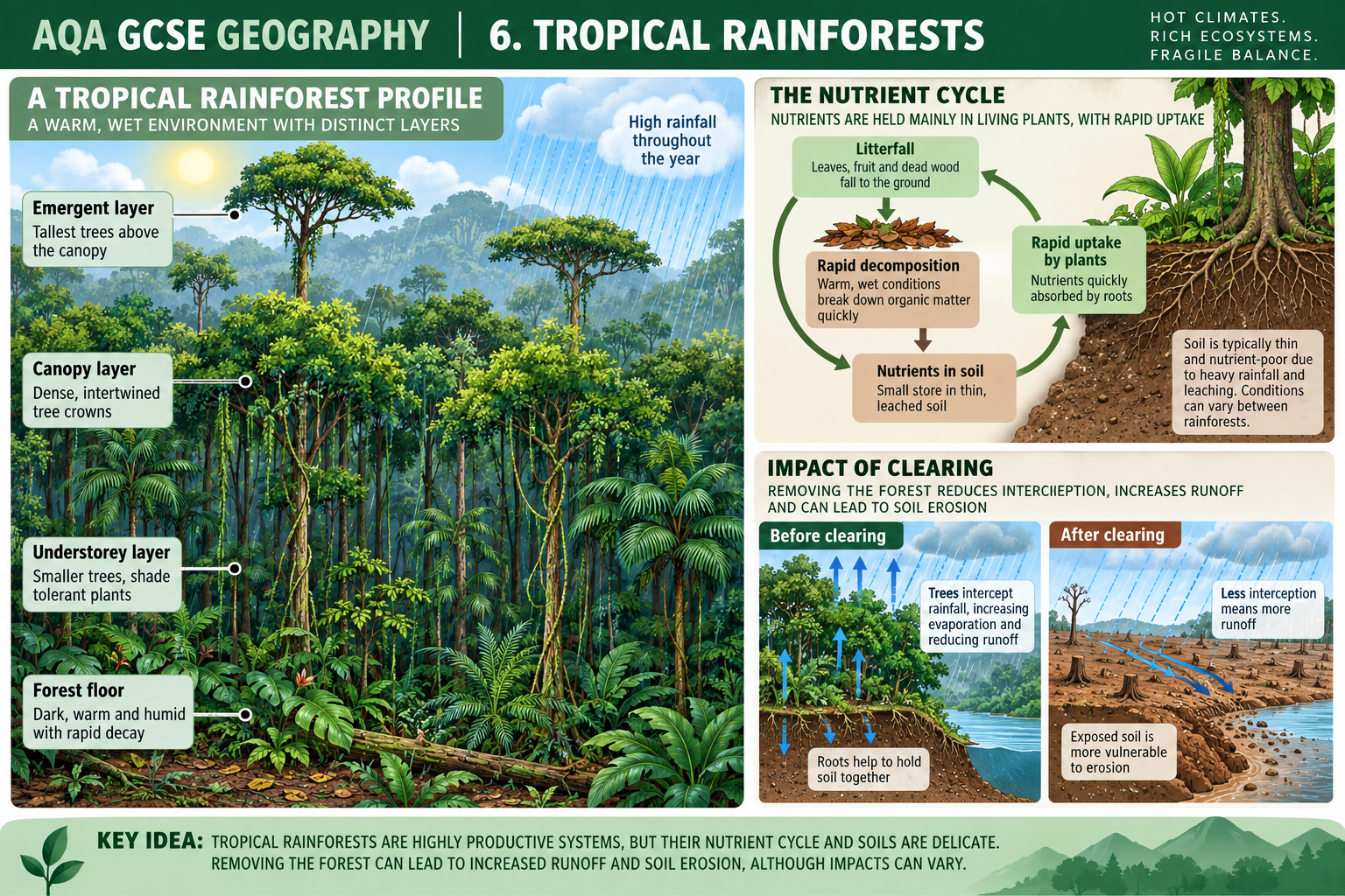
Tropical rainforests grow in warm regions with abundant rainfall through much or most of the year. Heat, moisture and sunlight support continuous plant growth, dense vegetation and rapid cycling of nutrients. The canopy shades the forest floor, and vegetation returns much of the absorbed water to the atmosphere through transpiration. Rainfall and plant growth are therefore connected: water is not simply delivered once from outside but repeatedly moves through soil, vegetation, air and rivers.
A large share of the nutrient store is held in living biomass and surface litter rather than in deep, fertile soil. Warm, wet conditions speed decomposition and plant uptake. Heavy rain can also leach nutrients from exposed ground. Clearing trees can break the tight links among canopy, rainfall interception, roots, soil and local water movement. The change affects people as well as wildlife because forests support livelihoods, water quality, transport, climate regulation and cultural identity.
Deforestation has multiple causes. Farming, timber, roads, mining, dams and settlement are direct ways land use changes. Commodity demand, government decisions, land rights, infrastructure, technology, finance and population distribution shape those direct actions. Sustainable management must therefore combine protection, monitoring, livelihoods and rules that address the causes at more than one scale.
1. Where tropical rainforests occur
Tropical rainforests occur mainly within the tropics, close to the Equator. The largest continuous areas are in the Amazon Basin of South America, the Congo Basin of central Africa and parts of South-East Asia. There are also smaller areas in Central America, the Caribbean, Madagascar, New Guinea and northern Australia.
Their broad distribution is linked to atmospheric circulation. Strong solar heating near the Equator warms moist air, encouraging it to rise. As it rises, it cools and water vapour condenses into cloud and heavy convectional rain. The Intertropical Convergence Zone, where trade winds meet and air rises, shifts north and south seasonally. Near the Equator, some places experience rainfall in more than one season; others have a clearer wet and drier period.
The word tropical does not mean identical. Local rainfall depends on the position of the convergence zone, prevailing winds, topography, ocean influence and distance from the sea. Mountain slopes can be wetter on one side than another. Some areas have a pronounced dry season, while others remain wet throughout much of the year. The forest edge may grade into savanna, seasonal forest, wetlands or agricultural land.
Rainforests should not be mapped as a single continuous belt with exact borders at the tropics. Human land cover, seasonal climate, altitude and historical vegetation all affect where closed forest occurs. Satellite maps can show current canopy cover; biome maps usually generalise the broad ecological region.
2. Rainforest climate
Temperature and sunlight
Equatorial locations receive strong solar energy throughout the year because the Sun is high in the sky and day length varies less than at higher latitudes. Rainforest temperatures are usually warm, and annual temperature ranges are often smaller than daily or seasonal ranges at higher latitudes. Cloud cover and dense vegetation moderate conditions locally.
Warmth supports biological activity, but temperature alone does not make a rainforest. Plants also need water, nutrients and suitable growing space. Areas with similar annual temperatures may have very different vegetation if rainfall seasonality differs.
Rainfall, humidity and seasons
Many tropical rainforests receive high annual rainfall, often from rising moist air and frequent convectional storms. Evaporation and transpiration add water vapour to the atmosphere, helping maintain humidity. Some forests have a drier season, but it may be shorter or less severe than in nearby savanna.
Rainfall is not always evenly distributed between months. An annual total can hide a short dry season or heavy storm months. Local climate graphs and maps should be used when comparing case-study sub-regions. A prolonged drought can stress trees even in a normally wet region, especially if high temperatures increase evaporation.
Climate and plant growth
High availability of heat, light and water can support high gross plant growth. However, not all that growth becomes new stored biomass. Plants respire, shed leaves, are eaten, and die. Nutrients are recycled quickly, while some carbon is released back into the atmosphere. Productivity varies between locations and seasons.
Rainforest climate also creates hazards. Intense rainfall can rapidly add water to rivers and can erode exposed soil. After clearance, a site may receive nearly the same rain as before, but without canopy interception and root systems, runoff and soil loss can rise. A change in the cover of the land modifies the way rainfall moves through the ecosystem.
3. Rainforest structure
Tropical rainforest vegetation forms layers because plants compete for light and grow to different heights. The exact height and number of layers varies by forest and by disturbance, but a simplified model identifies emergent trees, canopy, understorey and forest floor.
Emergent layer
The tallest trees rise above the main canopy and receive direct sunlight. They may face strong winds and high exposure, and their branches provide habitat for birds and insects. Their crowns are separated rather than forming a continuous roof. Tall trees need strong support, and wide buttress roots may help anchor some species in shallow or nutrient-poor surface soils. Buttress roots are an adaptation found in some trees, not every rainforest tree.
Canopy
The canopy is the largely continuous upper layer formed by tree crowns. It intercepts much of the sunlight and rainfall. Leaves, branches, vines and epiphytes create a complex habitat, with abundant food and shelter for many animals. The canopy often has high plant and animal diversity because it contains a range of microhabitats.
The canopy changes the conditions beneath it. It shades the ground, slows wind, intercepts some rainfall and returns water vapour to the air through transpiration. When a gap opens after a tree falls, more light may reach the forest floor and seedlings can grow rapidly. Natural gaps are part of forest dynamics.
Understorey and shrub layer
Smaller trees, shrubs, saplings, vines and shade-tolerant plants grow below the canopy. Light is lower, so some plants have large leaves that capture diffuse light. Lianas are woody vines that use trees as support to reach brighter canopy conditions. Epiphytes grow on other plants for physical support but are not necessarily parasitic; they obtain water and nutrients from rain, debris or the air.
Animal life is distributed through the layers. Some species feed or nest in the canopy, others forage on trunks, and others use the understorey or ground. A layered forest offers many niches and helps explain high biodiversity.
Forest floor
The forest floor receives less light than the canopy. It can be relatively open in intact, dense forest because little sunlight reaches the ground for grasses and shrubs. Fallen leaves, fruit, branches and dead organisms form litter. Warmth and moisture support rapid decomposition, though waterlogged or dry microsites can behave differently.
Roots and decomposers are active near the surface, recycling nutrients. The shallow root systems of many trees make nutrients in litter and topsoil quickly accessible. Exposed ground after clearance loses this protection and can be affected by heavy rainfall.
The importance of gaps and edges
A tree-fall gap allows additional light to reach plants below. Seedlings may grow rapidly, and the age structure of the forest becomes varied. This is one reason that an intact forest is a changing mosaic rather than an unchanging wall of trees.
An abrupt forest edge created by clearance can experience more wind, heat, drying and light than the interior. These edge effects can alter species composition, increase fire exposure and make fragments more vulnerable. A narrow strip of forest may therefore not function in the same way as a large connected forest, even if both appear green on a coarse map.
4. Interdependence: climate, water, soil and vegetation
Interdependence means that parts of a system affect and rely on one another. In a tropical rainforest, climate, water, soil, plants, animals and people are connected by flows of energy, nutrients and material. A cause-and-effect diagram should include arrows in both directions where feedback exists.
Water moving through the rainforest
Rainfall reaches the canopy first. Some water is intercepted on leaves and branches, where it evaporates back into the air. The rest drips through gaps or flows down tree trunks. Leaf litter and vegetation slow the water reaching the ground. Roots help the soil absorb and retain water, although the amount depends on soil structure, slope and rainfall intensity.
Plants take up water through roots and release water vapour through transpiration. Evaporation from soil and water bodies adds further vapour. Water vapour condenses into cloud and returns as rainfall. This local or regional recycling supplements moisture transported from the Atlantic and other sources. The share of rainfall recycled within the forest varies by place and season; do not assume every rainstorm is caused solely by the nearby trees.
Water that is not intercepted or absorbed may become surface runoff and enter streams and rivers. Forest clearance can increase runoff if it removes canopy, roots and litter, particularly where soil becomes compacted or roads and farms channel water. Soil erosion and sediment in rivers can then affect aquatic habitats, water quality, navigation and flood risk.
Soil and nutrients
Many tropical rainforest soils are deeply weathered and contain relatively low concentrations of readily available nutrients. Warmth and heavy rainfall over long periods can weather rock and leach soluble minerals downward or away. The most active nutrient store in many forests is the living vegetation and decomposing litter at the surface, not a deep layer of rich topsoil.
Rapid biological cycling helps keep nutrients available. Leaves fall; fungi, bacteria and small animals break down litter; mineral nutrients are released; roots take them up; and nutrients move through feeding relationships. The cycle is fast, but it is not perfectly closed. Leaching, erosion, river flow and harvest can export nutrients.
Not every tropical soil is poor. Floodplains can receive nutrient-rich sediment from upstream, while volcanic or unusual parent materials may create different soil conditions. A case-study answer should use specific evidence rather than claim that all tropical rainforest soils are identical.
Plants shape the water and soil conditions
Canopy cover reduces the direct impact of raindrops and intercepts some water. Roots bind soil, create channels for infiltration and take up nutrients. Leaf litter protects the surface from raindrop impact, adds organic matter and feeds decomposers. Vegetation also shades soil, moderating temperature and moisture.
Removing the vegetation weakens these processes. Bare soil receives direct rainfall, and nutrients that were stored in plants are released when biomass is burned or decomposes. Without roots and litter, soil can be washed away or compacted. Replanting may restore some cover, but the structure and biodiversity of an old forest do not return immediately.
Animals and plants
Plants provide food, nesting sites and shelter. Animals pollinate flowers, disperse seeds, browse leaves, prey on other animals and contribute to nutrient movement. Some plants depend on a particular animal for pollination or seed dispersal, while animals may depend on fruit or insects from particular plants.
These relationships can link distant parts of the forest. A fruit-eating animal may carry seeds away from the parent tree. A pollinator may move between plants. If a species declines, its effect can spread to others that rely on it. However, species may have alternative food sources or partners, and the exact impact depends on the food web.
People within the system
People are part of rainforest systems. Indigenous peoples and local communities may use forests for food, materials, medicines, transport, cultural practice and knowledge. Forest products can support local livelihoods and national economies. Decisions about logging, farming, roads, conservation and land rights change both the ecosystem and people’s access to it.
It is inaccurate to describe tropical forests as empty wilderness. Forest landscapes have long histories of habitation, management and stewardship. Human impact varies: a community’s subsistence use is not equivalent in scale or purpose to industrial conversion, and neither should be described without evidence. Sustainable management needs to recognise the rights, knowledge and needs of people who live in or depend on the forest.
5. Plant and animal adaptations
An adaptation is a characteristic that helps an organism survive or reproduce in particular conditions. It may be structural, physiological or behavioural. Adaptations usually involve trade-offs: a feature that is useful in one condition may have a cost in another. GCSE explanations should connect the feature to the physical condition and the benefit it gives.
Plant adaptations
Broad leaves can capture light, especially in shaded understorey conditions. In very wet environments, some leaves have pointed drip tips or smooth surfaces that help water drain. This can reduce the time that water remains on leaf surfaces, although the value of a specific leaf feature depends on the plant and local conditions.
Shallow, spreading roots can take up nutrients quickly from the surface litter and upper soil. They may also spread across a wide area for stability and water uptake. Some tall trees develop buttress roots that help support their trunks in shallow soils. A tree may also send some roots deeper where the local ground permits.
Lianas climb trees to reach sunlight without building a thick trunk capable of supporting the whole plant. Epiphytes, including some orchids and ferns, grow on branches where they can access light; they collect water and nutrients from rain, dust and organic debris rather than drawing them directly from a host tree in the way a parasite would.
Shade tolerance enables seedlings and understorey plants to survive with less light. Some species grow rapidly when a canopy gap appears, using the sudden increase in sunlight. Different strategies allow species to occupy separate layers and life stages.
Some plants have fruit or other structures that attract animals, supporting seed dispersal. Others use wind or gravity. A plant’s dispersal strategy affects where seedlings can establish, especially in fragmented forests where suitable habitat is separated.
Animal adaptations
Camouflage can make an animal harder to see against leaves, bark or dappled light. Mimicry can make one species resemble another, sometimes reducing the chance of attack. These patterns are useful only in particular backgrounds or against particular predators.
Arboreal adaptations help animals live in trees. Gripping feet, claws, flexible joints, strong tails or gliding membranes can assist movement between branches, but the exact features vary among species. A canopy-dwelling animal may rarely need to descend to the forest floor.
Many tropical animals use specialised diets to reduce competition. A bird may feed on fruit of a certain size; an insect may use a particular plant; a predator may hunt in a particular layer or time of day. Specialisation can be efficient when resources are available but can make a species vulnerable if its habitat or food disappears.
Nocturnal behaviour can help some animals avoid daytime heat or predators and find food at night. Others are active in daylight. Seasonal breeding, migration, territorial behaviour and communication also help animals respond to rainforest conditions.
Limits and misconceptions about adaptation
Adaptations develop over generations through natural selection; an individual animal does not choose to evolve a new feature because conditions change. Behaviour can change more quickly, and individuals may adjust activity, but the population’s inherited adaptations do not appear on demand.
A feature should not be labelled an adaptation unless its function is explained. For example, “large leaves are an adaptation” is incomplete. Explain that large leaves can capture more light in a shaded layer, but may also increase water loss or suffer more damage in exposed conditions.
6. Biodiversity and its value
Biodiversity is the variety of life. It includes the range of species, genetic variation within species, and differences among habitats and ecosystems. Tropical rainforests are known for high biodiversity, but no single statistic captures all species, and many organisms have not been fully described.
High biodiversity is linked to habitat complexity, year-round growing opportunities in many areas, and the wide range of ecological niches created by layered vegetation, varied food sources and local conditions. Long periods of evolution and geographic isolation also contribute to distinctive species.
Why biodiversity matters
Species and genetic diversity can make ecosystems more resilient to some changes by providing different responses to disturbance. If one species declines, another may perform part of a similar ecological role, though species are not fully interchangeable. Diverse ecosystems can support pollination, nutrient cycling, carbon storage, water regulation and food webs.
Rainforests have direct value to people. They provide timber and non-timber products, food, fibres and compounds used in medicines. They support water supply, river systems and local climates. They have cultural and spiritual value for Indigenous and local peoples. They also have global value through carbon storage, biodiversity and the movement of water and energy.
Potential future value matters too. A species may contain genetic or chemical properties that are not currently understood. Losing a species before it is studied can remove future options. At the same time, conservation should not reduce a forest to a storehouse of resources for outsiders; the rights and priorities of residents matter.
Threats to biodiversity
Forest clearance removes habitat. Logging can change the structure of the forest even when it does not remove all tree cover. Roads split habitats, allow access and increase edge effects. Hunting, fires, pollution, dams and climate change can add pressures.
Fragmentation isolates populations. A species may be unable to cross cleared agricultural land or a busy road. Smaller patches may have fewer habitat types, more edge relative to area and greater exposure to drying or fire. Wildlife corridors can connect patches, but corridor success depends on width, condition, species behaviour and surrounding land use.
Climate change can shift temperature and rainfall conditions. A species adapted to a narrow range may lose suitable habitat; a mountain species may have limited space to move upward. Drought can stress trees and increase fire risk. Climate and deforestation can interact: reduced forest cover may alter evapotranspiration and rainfall recycling, while drought makes the remaining forest more vulnerable.
7. Deforestation and forest degradation
Deforestation is the conversion or complete removal of forest cover, usually to another land use. Forest degradation is a decline in forest condition or ecological function while some tree cover remains. Selective logging, fire, repeated extraction and fragmentation can degrade a forest before it is fully cleared.
These terms are not identical, and monitoring methods use operational definitions. A satellite system might record clear-cut areas above a minimum size, while not measuring all selective logging, small clearings, understory damage or ecological degradation. A rate is meaningful only when its definition, area, dates and method are known.
Deforestation may be shown as a rate, such as square kilometres per year, or as cumulative area lost. A lower annual rate means less clearance during that measured period than during a higher-rate period; it does not mean the forest has regrown or that clearance has stopped. Reforestation and secondary vegetation require separate evidence.
Global rate patterns
Deforestation rates vary by country, region and time. Global reporting periods may cover multiple years and combine different national methods. National satellite programmes often provide more detailed annual data for a defined jurisdiction. Rates can rise or fall because of commodity prices, drought and fire, infrastructure, credit, land policy, enforcement and land tenure.
The Amazon demonstrates why dates and method matter. Brazil’s INPE reported a consolidated PRODES rate of 5,731 square kilometres for the Legal Amazon in the reporting period from 1 August 2024 to 31 July 2025. This was 12.07% lower than the consolidated 2024 rate of 6,518 square kilometres. PRODES defines its deforestation measure around complete removal of primary forest cover or the final stage of progressive degradation where the full canopy is lost. It is a satellite-based measure used for public policy.
This statistic does not describe every forest change. The Brazilian Legal Amazon is not exactly the same boundary as the Amazon biome and does not include all Amazon countries. The annual measure excludes many small clearings below the series’ area threshold and is not a full measure of degradation, fires or ecological quality. A falling rate is encouraging evidence of reduced measured clearance during that period, but total accumulated forest loss remains and monitoring must continue.
Deforestation, degradation and land cover
A satellite image can show forest loss, but interpreting it needs a land-cover sequence. A cleared patch might become pasture, a crop field, a mine, a road corridor, a reservoir, secondary forest or abandoned land. The land use can change again. A time series is more useful than a single before-and-after image because it shows when clearance occurred and what followed.
Regrowth is not automatically equivalent to the original forest. Secondary forest can store carbon, support wildlife and restore some ecological processes, but its species, structure and functions may differ from mature forest. A planted timber stand can have tree cover while supporting fewer native species and a different nutrient cycle.
Place example
The Amazon rainforest is the named place example in this guide, with detailed evidence focused on Brazil’s Legal Amazon monitoring area. It is a suggested teaching example; use the rainforest or sub-region selected by your teacher if your course differs.
8. Amazon rainforest case study
The Amazon Basin covers a large part of northern South America and drains toward the Atlantic. The Amazon rainforest is the largest tropical rainforest region. It spans national borders and contains enormous variation in rainfall, elevation, river type, vegetation and human settlement. The case study here focuses mainly on the Brazilian Legal Amazon and its surrounding economic connections.
The Amazon is not empty or uniform. Cities, Indigenous territories, river communities, farms, transport routes, protected areas and extractive activities coexist across the region. Different groups have different interests and power. A useful case study names the places and actors involved instead of treating “people” or “the government” as a single viewpoint.
Economic and social context
The forest supports Indigenous peoples and other traditional communities whose livelihoods and cultural identities are closely connected to land and water. River travel, fishing, small-scale agriculture, forest products and community knowledge are part of many local economies. The region also contributes to national and global production through livestock, crops, timber, minerals, energy and transport.
Economic development can create employment, income, public revenue, roads, electricity and access to services. The benefits may be uneven. A large company, landowner, urban consumer, small farmer and Indigenous community may receive different benefits and bear different costs. Some people gain land or wages while others lose forest access, clean water, health or control over ancestral territory.
Demand also comes from outside the region. Beef and soy supply domestic and export markets; timber enters construction and manufacturing; minerals supply industry; electricity supports cities and businesses. Global demand can influence the value of clearing land even when consumers are far from the forest.
Subsistence and small-scale farming
Subsistence farming produces food mainly for household or local use. In shifting cultivation, a small area may be cleared and cultivated for a period, then left fallow so vegetation and soil can recover. In traditional systems, fallow periods, plot size and community knowledge may keep pressure lower than intensive permanent cultivation.
Population growth, loss of land, insecure tenure, market integration or a shorter fallow period can change the impacts. If land is cleared more frequently than it recovers, soil fertility may decline and farmers may need to clear new areas. The term shifting cultivation covers different practices; do not equate all smallholder farming with unsustainable clearance.
Small farmers may clear forest because they need land and lack alternatives or secure access to already cleared land. Policies to stop clearance are less likely to be fair or effective if they ignore food security, tenure, services and livelihoods.
Commercial farming and cattle
Commercial agriculture produces for sale and can involve large-scale pasture, crops or plantations. In the Brazilian Amazon, cattle ranching has been a major land-use pathway. Forest is cleared, sometimes initially through logging or fire, and the land is converted to pasture. Cattle provide meat and hides for domestic and international supply chains.
The causal chain can include road access, land speculation, credit, weak enforcement and demand for beef. Land may be cleared to establish a claim or raise asset value as well as to produce cattle. Once a road opens, transport costs fall and land becomes more accessible. A forest frontier can then attract farms, services and settlement.
Soy production has expanded in parts of the wider Amazon and neighbouring Cerrado. Soy can be used for food, animal feed and industrial products. Its relationship with direct deforestation varies by place and period; it can expand on existing pasture, indirectly displace cattle toward forest frontiers, or replace other land uses. The soybean moratorium and supply-chain commitments have influenced some direct conversion pathways, but do not remove every indirect pressure or apply equally across all regions and commodities.
Logging
Logging supplies valuable tropical hardwoods and other timber for building, furniture and trade. Selective logging removes chosen trees rather than clearing every tree at once. It can create jobs and supply timber with less immediate canopy loss than clear-cutting. However, heavy machinery and access roads can damage surrounding vegetation, compact soil and fragment habitat.
Logging roads can make remote forest accessible to further clearance. Illegal logging may undermine regulations and reduce the value of sustainable operations. If a concession does not monitor harvesting, protect waterways and retain seed trees, the forest may not regenerate as intended.
Logging is a cause of forest degradation and can lead to later deforestation when roads open areas to farming, mining or settlement. This is why the economic and environmental outcome depends on the whole chain, not only the number of trees felled.
Road building, settlement and population growth
Roads are built to connect towns, ports, farms, mines and energy sites. They can reduce travel time and transport costs, support trade, and give communities access to schools and health care. Major routes such as the Trans-Amazonian Highway were intended to promote access and development.
Road access can trigger a wider land-use sequence. Settlers, farmers and companies move along routes; land claims and clearance increase; smaller roads branch from the main corridor; and more forest becomes reachable. Settlements need food, wood and services, and new markets make production easier. Population growth can add demand for land and infrastructure, but it is not a complete explanation without considering policies, unequal land ownership and economic incentives.
Road effects extend beyond the surface cleared for construction. Roads fragment habitat, alter drainage, increase vehicle and human access, and make monitoring more difficult if institutions lack resources. Some roads serve local communities and essential public services; others mainly support extractive projects. Evaluating a road requires asking who it connects and who benefits.
Mineral extraction
The Amazon contains valuable mineral resources, including iron ore, bauxite, gold and other deposits. Mining creates jobs, export income and materials for industry. Large mines may use open pits, access roads, railways, power and processing facilities. These can produce extensive environmental change beyond the excavation site.
Mining can clear vegetation, remove soil, fragment habitats and alter river systems. Mine tailings, sediment and chemicals can affect water quality if poorly managed. Informal or illegal gold mining can spread along rivers and into protected or Indigenous territories. The scale and impacts vary by mineral, method, regulation and enforcement.
Mining employment can be short-term or unevenly shared, while local communities may experience pollution, land conflict or loss of access to fishing and forest products. A balanced case study distinguishes national revenue from local outcomes.
Energy development
Hydroelectric dams can generate electricity and regulate some river flows. They may support cities, industry and rural electrification. In the Amazon, a dam can create a reservoir that floods forest and settlements; construction also requires roads, power lines, workers and materials. Dams alter sediment, water flow, fish migration and aquatic habitats downstream.
Hydropower is low-carbon during operation compared with fossil-fuel generation, but it is not impact-free. Forest flooded behind a dam can release greenhouse gases as organic matter decomposes, especially in warm water. Displaced communities may lose homes, land, fishing grounds or cultural sites. The impact depends on reservoir design, location, consultation and mitigation.
Energy projects therefore involve choices about access to electricity, climate policy, river ecology, land rights and alternative power sources. The word renewable does not answer every sustainability question.
Settlement and urban expansion
New settlements and growing towns need housing, transport, food, water and services. Urban areas can become centres of education, health, government and trade. Their growth may bring economic opportunity, but can also require forest clearance and new infrastructure.
Urban expansion and migration are connected to employment, public policy, land ownership and services. People moving to a frontier may be seeking livelihoods rather than intending environmental harm. If land is insecure and formal services are absent, residents may rely on forest clearing and informal routes. Planning for housing and services can reduce unmanaged expansion.
9. Impacts of deforestation
Impacts are connected and operate at different scales. A clearing changes one place directly; altered river flow or smoke can affect areas downstream or downwind; carbon emissions contribute to global climate change. Separate immediate site effects from longer-term regional consequences.
Economic development and livelihoods
Deforestation can generate short-term economic benefits: timber, beef, crops, minerals, electricity, construction and employment. Governments can gain taxes or export revenue, and infrastructure can connect isolated populations to services and markets. These are real potential benefits, but the distribution matters.
Some jobs are temporary, dangerous or low-paid. Profits may flow to large firms or distant investors. Local prices can rise; land conflicts may displace residents; informal workers may have little protection. If soil quality declines or forest resources disappear, livelihoods can become less secure after the initial extraction period.
There are also opportunity costs. Forest may provide water regulation, food, materials, cultural identity, carbon storage and future economic options. A decision to convert forest should compare the lasting benefits of alternative land use with the value and rights attached to keeping it. Not all values are easily expressed in money.
Soil erosion and land degradation
The canopy intercepts raindrops, while leaf litter protects the ground and roots bind soil. After clearance, rain strikes exposed soil more directly. If soil becomes compacted by machinery or cattle, less water infiltrates. More surface runoff can detach and carry soil downslope into rivers.
Erosion removes the thin fertile top layer and organic matter. Nutrients may be leached or washed away. Soil can become less productive, especially if crops or pasture continue without restoration. Sediment can cloud rivers, cover aquatic habitat and raise river beds locally.
The effect is not identical everywhere. Soil type, slope, rainfall intensity, land cover, drainage and farming practice all matter. Some cleared land may remain productive with careful management; steep or heavily rained sites can be especially vulnerable. The important explanation links vegetation loss to changed soil and water processes.
Contribution to climate change
Trees and soils store carbon. Burning or decomposing cleared biomass releases some stored carbon dioxide. Loss of forest also reduces future carbon uptake. Fires can release carbon and smoke, and peat or wet soils may add further emissions when drained or burned. These emissions contribute to the enhanced greenhouse effect.
Forest loss may also affect rainfall. Less vegetation can reduce evapotranspiration and moisture recycling, potentially making some areas hotter or drier. Drier conditions can raise fire risk, causing further tree loss. The strength of these feedbacks varies across the Amazon and is an active area of research; avoid saying that one cleared field automatically causes a regional tipping point.
At the same time, climate change can increase drought stress and fire risk in some regions. This creates a two-way relationship: deforestation contributes to climate change and can alter local hydrology, while climate change may make forests more vulnerable.
Biodiversity and habitat
Clearance removes living space, food and breeding sites. Fragmentation isolates populations and increases edge effects. Selective logging may leave trees standing but alter species composition, canopy structure and microclimate. Roads increase access for hunting and settlement, putting pressure on wildlife beyond the road itself.
Loss of a species can affect pollination, seed dispersal, prey availability and other ecological relationships. Biodiversity change may reduce future resources and ecosystem resilience. The pace of loss may be faster than scientists can describe all species, particularly small or cryptic organisms.
Water and rivers
Forest removal can change interception, infiltration, evaporation and runoff. More runoff may increase sediment and alter the timing of river flow. Reduced moisture recycling may affect rainfall locally or regionally, though ocean moisture and atmospheric circulation also influence the water supply.
Mining, roads, dams and farms can affect river water through sediment, pollutants, altered flow or changed access. Rivers connect upstream land uses to downstream communities and ecosystems. A case study should distinguish forest clearance from other impacts that may arise from industrial activity.
Health, smoke and air quality
Fires used to clear or manage land can produce smoke that travels far beyond the burn. Smoke particles can irritate eyes and lungs, worsen asthma and reduce visibility. Fire can also escape into adjacent forest, especially under hot and dry conditions.
Deforestation and degradation can alter local conditions and human contact with wildlife, but disease outcomes depend on many factors and should not be oversimplified. Health impacts can include injuries, smoke exposure, loss of food or clean water, and disruption of community services.
People, rights and culture
People who depend on forests may lose access to land, hunting, fishing, medicines, building materials and places of cultural meaning. Indigenous territories can face encroachment, illegal extraction or conflict. Relocation or loss of customary access can affect language, identity and knowledge systems as well as income.
Other residents may gain from new roads, jobs, markets or electricity. Outcomes differ between groups and over time. A geographic evaluation should identify stakeholders: Indigenous peoples, local communities, small farmers, workers, businesses, consumers, governments and conservation organisations. Do not assume they share one view or receive equal power in a decision.
10. Sustainable management
Sustainable management seeks to meet present needs while keeping ecological functions and future options. In a rainforest, this means more than planting trees after clearance. It may involve protecting intact forest, limiting damaging extraction, restoring degraded land, maintaining livelihoods, enforcing rules and reducing demand for products linked to unsustainable clearance.
No single strategy resolves every cause. A protected area may reduce legal conversion but needs monitoring and local support. Selective logging may reduce canopy loss but can create roads and degradation. Ecotourism may provide income but depends on visitors, transport and community control. International rules matter only if products can be traced and enforcement is credible.
Selective logging and replanting
Selective logging removes chosen mature trees while leaving much of the forest standing. Compared with clear-felling, it can retain more canopy and reduce immediate soil exposure. Planned harvesting can leave seed trees, protect stream buffers and reduce road density. Replanting native species can help restore cover where regeneration is weak.
Its success depends on standards and monitoring. Heavy machinery can damage surrounding trees and compact soil. Roads can open access to farmers or illegal loggers. Removing too many valuable species can change composition and reduce habitat. Replanted trees may be a monoculture rather than a diverse forest, and seedlings may not survive drought, fire or competition.
Selective logging is more sustainable when harvest limits match growth, forest boundaries and tenure are clear, roads are controlled, workers are safe, local communities participate and independent audits verify results. Certification can help buyers distinguish products from better-managed operations, but only if standards are credible and supply chains are checked.
Reforestation, restoration and agroforestry
Reforestation replants trees on land that was previously forested; restoration aims to recover ecological functions, not just tree cover. Natural regeneration may be effective where seed sources remain and land pressure is low. Planting can speed recovery or establish native trees where the soil or seed bank has been damaged.
Agroforestry combines trees with crops or livestock. Shade trees, fruit, timber and soil protection can diversify income and improve habitat compared with open pasture or monoculture. It can reduce pressure to clear new forest if farmers have secure land and market access. It does not replace the full biodiversity or carbon store of intact rainforest.
Restoration needs locally suitable species, long-term care, fire management and community consent. Land rights matter: planting trees on land used by residents without agreement can create conflict. Measure survival, structure, species and ecological function over time, not simply the number of seedlings planted.
Conservation and protected areas
Protected areas can conserve habitats, limit legal land conversion and support biodiversity. Their boundaries can include national parks, biological reserves and other conservation units. Indigenous territories and community-managed forests can also protect forest through secure rights and stewardship.
Designation alone is not enough. Boundaries need mapping, governance and resources. Illegal logging, mining, land grabbing or fires can continue without monitoring and enforcement. A park may displace pressure to its edges if wider land use is not managed. Conservation should recognise customary rights, involve residents in decisions, and provide viable livelihoods.
Protected areas work best as part of connected landscapes that include corridors and sustainable-use zones. Wildlife, rivers and fire do not stop at a legal boundary, so surrounding farms and infrastructure matter.
Education and community participation
Education can explain forest value, biodiversity, fire risk, legal rights and sustainable land-use methods. School programmes, community monitoring and training can support conservation. Education is more effective when it is accessible, locally relevant and linked to opportunities and decision-making.
Information alone cannot overcome poverty, insecure land tenure or lack of services. If residents depend on clearing land for food and income, awareness campaigns without alternatives may have little effect. Community management can be stronger when residents have recognized rights, access to finance and a fair share of benefits.
Ecotourism
Ecotourism brings visitors to experience nature and local culture while aiming to conserve the environment and benefit communities. Income may support guides, accommodation, transport, park staff, crafts and local services. When communities own or control tourism, a greater share of the income may remain local.
Tourism can create jobs that depend on keeping the forest attractive and biodiverse. However, visitor access may require roads, airports, lodges and waste disposal. Tourism demand can fluctuate with economic crises, safety concerns, transport cost and seasonality. Benefits may be captured by outside operators; wildlife can be disturbed; cultural experiences can be commercialised.
To assess ecotourism, ask how visitor numbers are managed, who owns businesses, where revenue goes, how waste and water are handled, and whether local residents choose how their culture and land are represented. It is a possible livelihood strategy, not a guarantee of conservation.
International agreements on tropical hardwoods
International trade influences forest use because hardwood demand can drive logging. Agreements and trade rules can restrict trade in threatened species, require legal documentation and encourage sustainable timber sourcing. The Convention on International Trade in Endangered Species of Wild Fauna and Flora (CITES) regulates international trade in listed species through permits and controls; it does not ban all tropical timber.
Other approaches include public purchasing rules, certification and supply-chain due diligence. Buyers can ask where timber was harvested and whether permits and management plans are valid. Monitoring is difficult when wood is mixed, mislabeled or moved through complex supply chains.
International agreements can reduce incentives for illegal or unsustainable trade, but they need national implementation, enforcement, transparent tracking and alternatives for workers and communities. Trade restrictions alone may shift timber sourcing to another region or encourage illegal markets if enforcement is weak.
Debt reduction and debt-for-nature approaches
Some lower-income countries face large debt repayments and pressure to earn foreign currency. A debt-for-nature arrangement can restructure or reduce some debt in exchange for commitments to fund conservation, protected areas or sustainable development. This can create longer-term local finance and connect international creditors to forest protection.
The value depends on the agreement’s scale, terms and governance. Conservation funding may be small compared with national debt or the economic return from extractive activity. Conditionality can affect national policy and sovereignty. Local communities need a voice in where funds go and how protected land is managed. Debt relief is not a substitute for fair trade, domestic enforcement or secure land rights.
Amazon Fund and policy packages
The Amazon Fund is one example of finance for prevention, monitoring, conservation and sustainable production. Brazil’s Action Plan for Prevention and Control of Deforestation in the Legal Amazon, known as PPCDAm, has used an integrated approach involving monitoring and enforcement, land-use and territorial planning, economic incentives and sustainable productive activities.
Brazil’s INPE operates satellite monitoring programmes including PRODES, which calculates annual deforestation rates, and DETER, which provides alerts intended to support timely action. Satellite monitoring can identify where change is occurring, but it does not by itself stop clearing. Agencies need the authority and resources to investigate alerts, enforce laws and resolve land conflicts.
Policy packages can coordinate government departments, local authorities, businesses and civil society. Their effectiveness can change when leadership, budgets, enforcement priorities or land-use rules change. A declining annual deforestation measure during one period is evidence of progress in that metric, but it does not prove that every ecosystem or community has recovered.
Supply-chain commitments and sustainable consumption
Companies and governments can commit to buying beef, soy, timber or minerals from supply chains that do not involve illegal clearance. Traceability links a product to its source; satellite data, land registries, audits and producer records can help. Moratoria and purchasing rules can influence traders and processors.
Commitments may exclude indirect conversion, small suppliers or regions outside the agreement. Products can be mixed or relabelled. A firm may meet a narrow “zero deforestation” promise while degradation, fire or land conflict continues. Independent verification and clear definitions are needed.
Consumers can reduce demand for products linked to unsustainable clearance, but responsibility should not be placed only on individual shoppers. Governments, banks, retailers, producers and international institutions shape rules, finance and market access.
11. Evaluating sustainable management
An effective evaluation compares benefits and limitations against the causes of forest loss. Use these questions:
- Does the strategy reduce the direct driver, such as land clearance, logging or fire?
- Does it address underlying causes such as commodity demand, tenure, roads, credit or enforcement?
- Is it large enough and located where the pressure occurs?
- Who pays, who gains income and who bears restrictions?
- Are Indigenous peoples and local communities involved with secure rights and meaningful choice?
- Is the strategy monitored over enough time to see whether forest condition improves?
- Could it shift pressure to another place, product or group?
Strategies often work in combination. Satellite alerts can locate clearance; enforcement can act on illegal operations; secure tenure can strengthen local stewardship; market rules can reduce demand for products linked to forest loss; and restoration can recover some functions on already cleared land. If one link is missing, the system may find another route to deforestation.
Sustainability also involves time. An intervention may create short-term jobs but degrade the land on which future livelihoods depend. Conservation may provide long-term benefits but impose immediate costs on households if alternatives are not funded. A good judgement states the timescale and distribution of both.
Maps, data and evidence
Reading a deforestation rate
Before quoting a rate, record:
- Place: Amazon biome, Brazilian Legal Amazon, a state, a protected area or a specific municipality?
- Period: calendar year, financial year, or August-to-July monitoring year?
- Unit: area cleared, percentage change, alert count or canopy-loss pixel?
- Definition: clear-cut loss, canopy degradation, fire damage or all tree-cover loss?
- Method: satellite resolution, minimum mapping unit, field verification and estimation status?
PRODES figures are used by the Brazilian government for annual monitoring and policy. In 2025, the consolidated figure was 5,731 square kilometres for August 2024 to July 2025, compared with 6,518 square kilometres in the previous reporting period. It is correct to describe this as a decline in the defined annual rate. It would be incorrect to say the Amazon gained forest, that all deforestation stopped, or that degradation and fire also fell by the same amount without checking their separate data.
Satellite imagery
Satellites allow repeated observation over large and remote areas. A time series can identify new clearings, changes in vegetation and the expansion of roads or settlements. Radar can collect information through cloud more effectively than some optical methods, although each sensor has strengths, limitations and classification uncertainty.
Images should be checked for date, resolution, cloud cover, colour scale and classification. A pale patch may represent cleared land, cloud, shadow, burn scar or seasonal vegetation depending on the image. Ground surveys and local knowledge can help validate remote-sensing classifications.
PRODES and DETER answer different operational questions. PRODES provides an annual rate using a defined method; DETER provides alerts to support monitoring and enforcement. An alert is not automatically a final estimate of annual area, and an annual estimate is not necessarily fast enough to direct immediate action.
Map patterns and causal explanation
On a map of the Amazon, describe where clearance clusters and how it relates to roads, towns, rivers, farms, mines or protected territories. Use the scale and key. Do not assume every clearing is caused by the nearest road; compare several features and use supporting evidence.
A location may be under pressure because it is accessible, has valuable land or resources, is near transport or markets, or has uncertain ownership. A causal account combines a map pattern with an explanation of decisions, infrastructure and demand.
Case-study data
Use a small number of figures well. A useful figure should show a trend, scale, distribution or impact. State what was measured, by whom and during which period. Explain what the figure can and cannot show.
Data may be revised as satellite processing improves. INPE’s consolidated 2025 PRODES rate differs from its earlier estimate for that period. When figures differ, identify whether one is an estimate and another consolidated result; do not combine them as if they were the same dataset.
Common misconception
Rainforest soils are not all deep and fertile. Many old, heavily leached soils store a large share of available nutrients in living biomass and surface litter. Floodplain and volcanic soils can differ.
High rainfall does not mean rain falls at an identical rate every month or that every tropical forest is wet in every season. Climate varies by region and year.
Clearing trees is not the only form of forest damage. Selective logging, repeated fires and fragmentation can degrade forest while some canopy remains.
A decrease in the measured deforestation rate does not mean deforestation has ended or the forest has recovered. It means the annual area under the stated measure was lower than in the comparison period.
Amazon Legal is not the same boundary as the Amazon biome. A Brazilian statistic should not be described as a total for every Amazon country unless its method covers them.
Indigenous and local communities are not one stakeholder group with one livelihood or opinion. Their rights, knowledge and priorities vary and should not be collapsed into a general label.
Tree planting is not automatically equivalent to protecting intact rainforest. A plantation may have tree cover but fewer species, different structure and a different carbon or water cycle.
A sustainable label does not prove that a product has no impact. Check how timber or crops were produced, what standard applies and whether the supply chain was audited.
Key vocabulary
| Term | Meaning |
|---|---|
| Adaptation | Feature or behaviour that helps an organism function in its environment; in climate geography, adjustment to climate impacts |
| Agroforestry | Land use that combines trees with crops or livestock |
| Amazon biome | Broad tropical forest and associated ecosystem region across northern South America |
| Amazon Legal | Brazilian administrative monitoring and policy region, not identical to the full Amazon biome |
| Biodiversity | Variety of life, including species, genetic and ecosystem diversity |
| Canopy | Upper layer formed by overlapping tree crowns |
| Commercial farming | Production for sale, often at larger scale or linked to markets |
| Deforestation | Conversion or complete removal of forest cover under a stated definition |
| Degradation | Decline in forest condition or function while some cover remains |
| Ecotourism | Tourism intended to conserve nature and provide local economic or social benefits |
| Emergent layer | Tallest rainforest trees rising above the canopy |
| Epiphyte | Plant growing on another plant for support without necessarily taking nutrients from it |
| Interdependence | Linked reliance between ecosystem components |
| Liana | Woody climbing vine using other plants for support |
| Nutrient cycling | Movement of nutrients through organisms and environmental stores |
| PRODES | INPE programme that produces Brazil’s official annual Amazon deforestation rate using a defined remote-sensing method |
| Subsistence farming | Farming mainly to provide food or livelihood for the household or local community |
| Sustainable management | Use and protection that balances present needs with ecological functions and future options |
| Transpiration | Water vapour released from plants, mainly through leaves |
Self-check
Use the questions to practise definitions, process explanations and case-study reasoning. For longer questions, add a location and evidence rather than relying on a memorised generalisation.
- Where are the world’s largest tropical rainforest regions located?
- Explain how equatorial heating can lead to frequent rainforest rainfall.
- Why is rainfall seasonality as important as annual rainfall?
- Name the main vegetation layers in a tropical rainforest.
- How can the canopy affect rainfall and conditions on the forest floor?
- Explain the difference between interception and transpiration.
- Why are nutrients rapidly cycled in many rainforests?
- Why may many tropical rainforest soils contain relatively few available nutrients?
- Explain one way plants and animals are interdependent.
- How can forest clearance alter runoff and soil erosion?
- Give two plant adaptations and connect each to a physical condition.
- Give two animal adaptations and explain how each may help an organism.
- Why is a specialised species sometimes vulnerable to habitat change?
- Distinguish between deforestation and forest degradation.
- Name four causes of deforestation that AQA expects you to understand.
- Explain how road building can lead to further forest clearance.
- What was the consolidated PRODES rate for Brazil’s Legal Amazon in 2025, and what was its reporting period?
- Why should the PRODES statistic not be treated as a total measure of all forest damage?
- Explain one economic benefit and one environmental cost of commercial farming.
- How can logging create jobs and still increase future forest loss?
- Explain how deforestation can contribute to climate change.
- Why can forest fragments have greater edge effects than continuous forest?
- Give two advantages and two limitations of protected areas.
- What makes selective logging more sustainable than unmanaged extraction?
- Explain how an international timber agreement or supply-chain rule may reduce forest loss.
- Why can ecotourism support forest conservation but also create new pressures?
- What is a debt-for-nature approach, and what issue must be considered in evaluating it?
- How does satellite monitoring support forest management, and why is it not enough by itself?
- Why does sustainable rainforest management need to consider local and Indigenous rights?
- Explain why secondary forest or a plantation is not necessarily equivalent to intact rainforest.
Short answer guide
- Mainly near the Equator, with the largest areas in the Amazon, Congo Basin and South-East Asia.
- Strong heating warms moist air; it rises, cools and condenses to form cloud and rainfall.
- A long dry season can create water stress even if the annual total is high; plant growth depends on timing and reliability.
- Emergent layer, canopy, understorey or shrub layer, and forest floor.
- It intercepts rainfall, shades lower layers, reduces wind exposure and returns water vapour through transpiration.
- Interception is rainfall caught on leaves and branches; transpiration is water vapour released by plants.
- Warm, moist conditions support rapid decomposition and plant uptake, transferring nutrients quickly among litter, soil and biomass.
- Long-term weathering and heavy rainfall can leach soluble minerals; much nutrient content may be held in vegetation and litter.
- Plants provide food or shelter; animals may pollinate flowers or disperse seeds. Explain a specific link.
- Less canopy, litter and root cover exposes or compacts soil; runoff can increase and carry soil into streams.
- Examples include shallow spreading roots for surface nutrients, buttress roots for support, drip tips for water shedding or lianas climbing toward light.
- Examples include camouflage to avoid detection, gripping feet for branch movement, specialised diet to use a niche or nocturnality to avoid daytime heat or predators.
- If it depends on a narrow habitat or food source, clearance may remove the specific conditions it needs and it may not adapt or relocate quickly.
- Deforestation is forest conversion or complete removal; degradation is reduced ecological condition or function with some tree cover remaining.
- Farming, logging, roads, mineral extraction, energy development, settlement and population growth; any four.
- Roads lower access and transport costs, encouraging settlement, land claims, extraction and secondary roads beyond the cleared corridor.
- 5,731 square kilometres, for 1 August 2024 to 31 July 2025.
- It measures a defined form of canopy removal over a stated region and threshold; it does not include every small clearing, degradation, fire or the entire multi-country biome.
- Farming can create food, exports, income and jobs; it can also remove habitat, erode soils, release carbon and affect water. Explain one of each.
- Timber supplies markets and employment, but access roads and canopy damage may enable agriculture or settlement if governance is weak.
- Burning or decomposition releases carbon stored in trees and soil; fewer trees remain to remove carbon dioxide from the atmosphere.
- More edge per unit area increases exposure to drying, wind, light and fire, changing habitat conditions.
- They can conserve habitat and limit legal conversion; limitations include weak enforcement, lack of funding, displaced pressure or conflict if local rights are ignored.
- Harvest limits, mapped boundaries, protected stream buffers, reduced road damage, regeneration, monitoring, community involvement and enforcement.
- Permits, sourcing requirements or certification can reduce demand for illegally or unsustainably harvested species when traceability and enforcement work.
- Visitor income may support livelihoods and conservation; transport, infrastructure, waste, disturbance and unequal ownership can create pressure.
- Debt is restructured or reduced in exchange for conservation commitments or finance; assess scale, terms, governance and community participation.
- Satellites map change over large areas and flag where action may be needed; agencies still need resources, authority and local investigation to respond.
- Forests support livelihoods, culture, knowledge and land rights; excluding residents may be unfair and undermine stewardship.
- Secondary forest and plantations can restore some cover or services, but may differ from intact forest in structure, species, biodiversity and carbon or water functions.
Revision points
- Locate rainforests broadly near the Equator and explain the pattern through rising moist air, while recognising seasonal and regional variation.
- Describe the layers and explain how competition for light shapes vegetation structure.
- Trace water through interception, infiltration, runoff, evaporation and transpiration.
- Explain why biomass and litter can hold many nutrients and why exposed ground is vulnerable to erosion and leaching.
- Link each plant or animal adaptation to a physical condition and state any relevant trade-off.
- Use a food-web or water-cycle chain to explain interdependence instead of listing components.
- Separate direct causes of deforestation from underlying demand, policy, tenure, transport and finance.
- Describe the Amazon statistic with its reporting period, boundary and method; a lower rate is not the same as recovery.
- Give both economic benefits and environmental and social costs.
- Evaluate sustainable management by effectiveness, scale, funding, enforcement, rights, livelihoods and displacement of pressure.
Curriculum alignment
- Curriculum coverage ID: aqa.3.1.2.tropical-rainforests
- Related practice packs: gcse_geo_p1_physical_environment_june_2022, gcse_geo_p1_physical_environment_june_2023, gcse_geo_p1_physical_environment_june_2024, gcse_geo_p1_physical_environment_november_2020, gcse_geo_p1_physical_environment_november_2021
- Shared concept tags: tropical-rainforests, biodiversity, deforestation, sustainability, amazon, nutrient-cycles, water-cycle
Sources and further reading
- AQA GCSE Geography 8035, Living with the physical environment: Specification content
- AQA: Subject-specific vocabulary for GCSE Geography
- NASA Earth Observatory: Tropical deforestation and its effects
- NASA: Rainforest biome overview
- Instituto Nacional de Pesquisas Espaciais: Consolidated PRODES deforestation rate for 2025
- INPE: PRODES 2025 technical note and method
- INPE: TerraClass 2024 mapping of land cover and use in the Amazon biome
- FAO: Drivers of deforestation and options for action
- FAO: Indigenous peoples and traditional forest-related knowledge
- FAO: Principles of sustainable tropical forest management
- Brazil Ministry of Environment: PPCDAm action plan, fifth phase
- Brazil Ministry of Environment: PPCDAm results for 2023–2025
- Brazil ICMBio: PPCDAm and federal conservation action
The PRODES figure is a dated, consolidated national statistic for a defined monitoring area. Use a more recent official value if your school or an assessment supplies one, and keep its method and reporting period with it.