 FoxChild@Learn
9. Physical landscapes in the UK
Curriculum status: Required core content.
This guide follows AQA GCSE Geography 8035. Named examples below are suggested teaching examples where the specification allows a school choice; use your teacher’s selected case study and verify current figures before an assessment.
Required knowledge
- Locate major UK upland and lowland areas and river systems.
- Explain how geology, relief and physical processes contribute to landscape diversity.
- Apply this overview to the two landscape options studied by your school.
Key vocabulary
| Term | Meaning |
|---|---|
| upland | higher land, often with steeper relief |
| lowland | lower and generally gentler land |
| relief | height and shape of land |
| drainage basin | land drained by a river and tributaries |
| landscape | visible features shaped by physical and human processes |
How the geography works
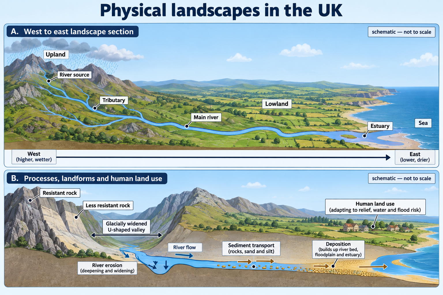
The UK’s geology and past glaciation help explain variation in relief, drainage and coastlines. Rivers connect uplands to lowlands and the sea, transferring water and sediment. Human land use interacts with these systems, so physical landscapes are dynamic rather than static scenery.
Place example
Use a UK relief map and one named river system. Upland and lowland labels are broad patterns: thresholds and boundaries depend on the dataset or teaching map. This overview supports the coastal, river and glacial options.
Maps, data and evidence
Read contours and river networks at appropriate scale; identify source, tributaries, confluence and mouth. Compare physical maps with settlement or land-use maps to explore interaction, not to assume direct causation.
Common misconception
The specification requires the overview plus two of three landscape options. A single UK landscape example does not represent all regions.
Self-check
- What does a relief map show?
- How can upland areas influence a river downstream?
- Which two UK landscape options does your school study?
Revision points
Know the broad locations and river systems, then revise the two options selected by your school. The three option guides are provided so the library covers every valid route.
A physical geography portrait of the UK
Start with location and scale
The United Kingdom comprises Great Britain and Northern Ireland, together with many islands. Great Britain includes England, Scotland and Wales. The four nations contain high ground, lowland basins, plateaux, valleys, plains, coasts and islands. Because the country is relatively small, a map can make its variation visible, but the labels “upland” and “lowland” are broad descriptions rather than one universally agreed elevation boundary.
For AQA, the key task is an overview: locate the major upland and lowland areas and river systems. You are not expected to memorise a complete inventory of every hill and watercourse. Be able to orient yourself, identify the broad physical pattern and use named examples accurately. The specification then requires two of the three options: coasts, rivers and glaciated landscapes. This guide supplies the shared context; the next three guides contain the selected topic detail.
Think about scale in three steps. First, locate the UK in north-west Europe and identify its surrounding seas. Second, describe the broad distribution of uplands and lower areas across the four nations. Third, zoom in to one named catchment or landscape. Avoid trying to describe the whole country from a close-up map of one national park.
Broad pattern of uplands and lowlands
Scotland has extensive high ground, especially in the Highlands and Grampian Mountains north and west of the Great Glen. Ben Nevis is the highest summit in the UK. The Central Lowlands form a lower corridor between the Highlands and the Southern Uplands, although “lowland” does not mean perfectly flat. The Southern Uplands lie north of the English border and include hills and valleys. Scotland also contains low-lying coastal plains, islands and many lochs, so it is not simply a single mountain region.
Wales is predominantly upland and dissected by river valleys. The Cambrian Mountains form a broad upland spine; Eryri (Snowdonia) contains the highest mountains in Wales; the Bannau Brycheiniog rise in the south. Lower coastal strips, estuaries and valleys are important places for settlement and transport. The boundary between an upland and a neighbouring plain may be gradual rather than a sharp line on the ground.
England has a broad north-west to south-east contrast, but it is not a straight border. Uplands include the Lake District, Pennines, Yorkshire Dales, North York Moors, Peak District, Exmoor and Dartmoor. The Pennines run broadly north–south and are often called the “backbone of England,” but this phrase is a mnemonic rather than a geological unit. Lower landscapes are extensive in central, eastern and southern England and include the East Anglian plain, the Midlands, the Vale of York, the Cheshire Plain, the Thames Basin and parts of the south coast. The Cotswolds and South Downs are elevated chalk or limestone landscapes despite lying in southern England.
Northern Ireland includes the upland areas of the Sperrin Mountains, Mourne Mountains and Antrim Plateau, as well as lower basins and coastal lowlands. Lough Neagh occupies a broad low-lying basin near the centre of the region. The Antrim Plateau includes basalt landscapes shaped by volcanic rock and later processes. The country’s varied geology and topography are described in the British Geological Survey’s regional summaries (BGS, Northern Ireland).
These patterns are a starting point for map reading, not a claim that high ground is always in the west or that all southern land is flat. Local geology can produce prominent hills in otherwise lower regions, and river valleys can cut through upland terrain.
Major river systems and their settings
Rivers drain water from a drainage basin, an area bounded by higher land known as a watershed. Small tributaries join to form larger channels; a confluence is where two rivers meet; a river mouth is where a river enters the sea or a larger body of water. A drainage-basin map helps show how water from uplands is connected to lower reaches and coasts.
The River Severn rises in the Cambrian Mountains of Wales, flows east and then south through the Welsh borderlands and western England, and reaches the Bristol Channel through its estuary. It crosses more than one national and administrative region, which makes it a useful example for thinking about catchment-wide management.
The River Thames drains parts of southern England and flows east through London to the Thames Estuary and North Sea. Its basin includes towns, agricultural land and a large metropolitan area. It illustrates how a river system crosses different land uses and receives inputs from many tributaries.
The River Trent rises in the Staffordshire Moorlands and flows through the Midlands to join the Humber estuary system. The River Ouse and its tributaries drain parts of Yorkshire; several English rivers share the name Ouse, so specify “Yorkshire Ouse,” “Great Ouse” or another named river to avoid confusion. The River Tyne, Tees, Mersey, Wye, Usk, Dee, Tay, Spey, Clyde, Forth and Shannon are other useful named systems across Britain and Ireland, but their lengths and catchment areas should only be quoted when a reliable source and definition are provided.
Rivers link uplands with lowlands by transferring water, sediment and dissolved material. Headwater streams can respond quickly to rainfall; larger downstream channels integrate flows from tributaries across a wider basin. This broad pattern helps explain why an event in the upper catchment can affect places downstream. The exact timing and size of that effect depend on geology, land cover, soils, drainage and human management.
Reading a relief and drainage map
A relief map uses colour, shading, contours or spot heights to represent elevation. A contour joins points of equal height. Closely spaced contours usually indicate a steep slope; widely spaced contours indicate a gentler slope. A river network is shown by blue lines, often with smaller tributaries joining a larger channel. Always check the legend: colour conventions differ between maps, and a shaded relief map may exaggerate slopes for visibility.
Use a simple sequence when describing a map:
- Give an overall pattern using compass directions or named regions.
- Locate one or two examples precisely, using nearby cities, landforms, grid references or coastlines.
- Describe the connection between relief and river direction or density if visible.
- Support a claim with a map feature, contour, scale or data value.
- State a limitation if the map omits geology, rainfall, land cover or seasonal variation.
For example, on a broad UK relief map you might identify a band of higher ground across parts of northern England, upland regions in Wales and Scotland, and lower areas across much of eastern England. You could then trace a named river from its upland source towards its estuary. If the map does not name a smaller tributary, do not infer its exact route from a coloured patch alone.
Why UK landscapes are diverse
Landscape is produced by the interaction of rock, structure, relief, climate, water, ice, vegetation, time and people. The same process can create different landforms when the underlying rock or energy conditions differ. A hard rock may stand out beside a softer one because it is worn away more slowly. A permeable rock can allow water to infiltrate, while an impermeable surface can encourage overland flow. Bedding, joints and faults influence where water enters and where erosion is concentrated.
The British Geological Survey explains that relief depends on rock hardness, permeability and structure. Resistant granite can form upland areas such as Dartmoor or Bodmin Moor; chalk can form escarpments and hills even though it is not the hardest rock, because its permeability can limit surface runoff; softer or impermeable rocks can form lower terrain when they are more easily eroded (BGS, relief). These are useful patterns, not rules with no exceptions. Quaternary deposits, tectonic structure, drainage and human activity also matter.
Past glaciation reshaped large areas of the UK. Ice eroded some valleys into broad troughs, overdeepened basins and created deposits such as till and moraine. Meltwater laid down sands and gravels in other settings. Glacial deposits can cover older bedrock and influence soils, drainage and relief. A present-day landscape can therefore reflect an older bedrock framework modified by ice and then further changed by rivers, weathering, slope movement, vegetation and people.
Weather and climate contribute to these patterns. The UK’s prevailing westerly winds bring moist air from the Atlantic. When air is forced to rise over western uplands, it cools and may produce enhanced rainfall. As air descends towards the east, rainfall can reduce, contributing to a broad west–east contrast. The Met Office identifies prevailing winds, passing Atlantic weather systems and orographic enhancement by western mountains as important reasons why rainfall varies across the UK (Met Office, UK rainfall). Rainfall is not solely controlled by relief: frontal systems, convection, local exposure, season and climate variability also affect it.
Relief and rainfall can affect river regimes. Steep slopes may route water downhill more rapidly; permeable rocks and soils can store some rainfall and release it slowly; saturated or impermeable surfaces may generate more surface runoff. These relationships are influenced by land cover, antecedent soil moisture, drains, reservoirs and urban surfaces. A relief map on its own cannot tell you the discharge of a river.
From uplands to lowlands: a connected landscape
Water and sediment move through catchments. Rainfall reaches vegetation, soil, rock and channels by interception, infiltration, percolation and overland flow. Streams join, and the main river transports sediment downstream. Some material is deposited when energy falls; some remains in suspension or solution. Erosion and deposition reshape channel beds, valley sides, floodplains, estuaries and coasts. The detailed processes are explained in the River Landscapes guide.
This connection has human consequences. Land-use choices upstream—such as farming, forestry, road construction or drainage—can change how quickly water runs off and which material enters channels. Downstream settlements may benefit from water supply and fertile floodplains, but they may also face flood risk or water-quality pressures. The relationship is not deterministic: flood defences, reservoirs, wetlands, warning systems, zoning and household preparation influence consequences.
Catchments also connect administrative boundaries. A river may flow through more than one local authority or nation, while a flood or water-quality issue crosses the same boundaries. Managing only one stretch can displace risk downstream or fail to address the original cause. Catchment partnerships therefore consider connected land and water rather than treating each river section as isolated.
Coasts are connected to inland landscapes through river sediment and estuaries. A river can deliver sediment to the coast, but dams, sediment traps, quarrying, channel management and geology affect how much reaches the sea. Waves, tides, longshore drift and cliff erosion then redistribute sediment. The Coastlines guide covers those processes. Here the key point is that a coastal landform can reflect both marine and terrestrial inputs.
Human landscapes interact with physical patterns. Settlements often occupy river crossings, coastal sites, flatter ground or routes through uplands, but this is not because relief alone decides where people live. Ports, transport, soils, employment, defence, historical decisions and technology also matter. Quarrying, reservoirs, agriculture, forestry, roads and dams can visibly alter a landscape and influence physical systems. The landscape we see is therefore both physical and cultural.
Landscape patterns across the four nations
Scotland: a strong north–south contrast
Scotland’s broad relief pattern is often introduced through the Highlands, Central Lowlands and Southern Uplands. These are useful regional divisions, but the ground within each is varied. The Highlands contain mountain blocks, plateaux, glens and lochs; valleys may follow faults or zones of weaker rock. The Central Lowlands contain urban areas, farmland, hills and river basins, and should not be drawn as a perfectly flat strip. The Southern Uplands are made up of rounded hills and valleys that connect with upland areas south of the border.
Several rivers drain from the higher ground. The Tay flows eastwards to the Firth of Tay; the Spey flows generally east and north-east to the Moray Firth; the Clyde flows through Glasgow towards the Firth of Clyde; the Forth reaches the Firth of Forth. A firth is a Scottish term for a sea inlet or estuary, though individual firths differ in shape and process. The Great Glen cuts a prominent north-east to south-west route through the Highlands and contains a chain of lochs, including Loch Ness. A named line on a map should be checked against its scale: a loch is not necessarily a through-flowing river.
Wales: upland sources and routes to the sea
Much of Wales has elevated ground, with rivers flowing from upland catchments towards the Irish Sea, Bristol Channel or estuaries. The Severn rises on Plynlimon (Pumlumon) in the Cambrian Mountains, then travels into England before reaching the Bristol Channel. The Dee rises in Snowdonia/Eryri, crosses north-east Wales and enters the Dee Estuary. The Wye rises in the Cambrian Mountains and flows south-east along part of the England–Wales border; the Usk flows east and south through south Wales to its estuary. These examples show how river catchments cross national and administrative boundaries.
Upland relief can create steep headwaters and narrow valleys, while lower downstream reaches may contain broader floodplains or estuaries. Do not infer every feature from the river name; landforms depend on the local geology, discharge history, sediment and human management. See the detailed rivers chapter for the processes and case evidence.
England: contrasting uplands and extensive lowlands
The Pennines and the uplands of northern England form a broad north–south belt, including the North Pennines, Yorkshire Dales and Peak District. The Lake District in north-west England has high, glaciated mountains and radiating valleys. The North York Moors form a plateau and scarp landscape east of the Pennines. In south-west England, Dartmoor and Exmoor are upland areas with moorland and river valleys. Southern England also contains the chalk landscapes of the North and South Downs and the limestone Cotswolds, which rise above adjacent lower ground.
Lower areas include the Cheshire Plain, Vale of York, Midlands and East Anglian plain. The Thames basin contains low-lying land, terraces, tributary valleys and a large urban area. The lower Severn crosses a floodplain before reaching an estuary. In east England, the Great Ouse and its tributaries drain a broad low-lying area towards The Wash. Coastlines, estuaries and river valleys add variation within regions that look low-relief at a small map scale.
Northern Ireland: basalt plateau, mountains and basins
Northern Ireland’s landscape is shaped by a varied geological history. The Antrim Plateau includes extensive basalt, associated with ancient volcanic activity; the Mourne Mountains include granite; and the Sperrin Mountains are another upland area. The lowland basin around Lough Neagh contrasts with these higher regions. The River Bann connects Lough Neagh to the north coast, while the River Erne system is associated with lakes and reaches in the west. The Foyle drains towards Lough Foyle in the north-west. Check the direction and names on a current map because rivers may pass through lakes, border regions or estuaries.
The wider lesson is that relief and drainage form regional patterns, while geological boundaries and rivers do not always match administrative divisions. A useful comparison identifies both contrasts and connections rather than presenting four separate lists.
Geological time and changing landscapes
The rocks beneath the UK formed over hundreds of millions of years in different environments, including ancient seas, rivers, deserts and volcanic settings. Plate movements, uplift, folding and faulting changed their position. Erosion later exposed some older rocks while younger sediments accumulated elsewhere. The present-day map is therefore a snapshot of a long sequence, not a plan that was created all at once.
Rock lithology means the physical character of the rock, including mineral composition, grain size, hardness, permeability and resistance to weathering. Structure refers to the arrangement of rock layers and features such as bedding planes, folds, joints and faults. A river may follow a fault or a weak rock zone; a coastal cliff may erode faster where joints are closely spaced. A landscape description becomes stronger when it explains which property of the rock affects which process.
The British Geological Survey’s regional summaries show how geology differs across England, Wales and Northern Ireland and provide local examples for further reading (BGS regional summaries). Their detailed maps are not all interchangeable: a bedrock geology map shows solid rock, while a superficial deposits map shows younger material such as glacial till, river alluvium or sand and gravel. A river valley may be cut into bedrock but have a floodplain covered by more recent sediment.
Past ice sheets and glaciers changed both high and low ground. Ice eroded valleys in uplands, moved large boulders, deposited till and produced meltwater sands and gravels. In lower areas, ice and meltwater left deposits that can influence present-day drainage and agriculture. Sea level also changed as water was stored in ice and later released; former coastlines and raised beaches can now sit above the modern shore. The glaciation chapter focuses on these processes and the named UK upland example.
Since ice retreated, rivers have incised valleys, deposited floodplain sediment and adjusted their channels. On slopes, weathering and mass movement continue to change relief. Along coasts, waves and currents erode and move material. Vegetation can stabilise some slopes and store water, while people alter drainage, build reservoirs, quarry rock, straighten channels or construct coastal defences. Physical landscape is dynamic across different timescales: a river can change after one storm, while a geological structure reflects a much longer history.
A worked map-reading example
Suppose a 1:250,000 map extract shows a high ridge in the west, close contour lines on its steep side and a stream that joins a larger river heading east. The river then crosses widely spaced contours and reaches a wide estuary. A careful description would say: the upper catchment begins in higher relief; the tributary joins the main river; lower relief occurs nearer the estuary. If the map includes scale, contour values and named places, use them to support the pattern.
An explanation could connect slope to faster surface routing, then note that soil, vegetation, rock permeability and rainfall influence how much water reaches the channel. Farther downstream, a wider valley may contain a floodplain, but a map alone does not establish when it formed or how often it floods. You would need field evidence, historical records or a more detailed geomorphological source.
Now overlay a geology map. If the upland is resistant rock and the lower valley includes softer rock or thick glacial deposits, this may help explain relief and channel form. Still, an association between rock type and elevation does not prove rock hardness is the only cause: structure, glacial history and river erosion also contribute. The best interpretation uses more than one evidence layer and keeps claims within the map’s scale.
For a field sketch, place the horizon and visible slopes first, then label a stream, valley sides, vegetation, land use, buildings and any exposed rock. Add annotations that connect observation to a process: “steep slope channels runoff” or “floodplain land is visibly flatter.” Distinguish what you can see from what you infer. A sketch should simplify a view, not pretend to be a precise survey.
Using landscape evidence at different scales
A national relief map is useful for broad patterns, but it may generalise smaller features. A lowland area on a national map can still contain hills, escarpments and steep river valleys. A mountain range shown as one shaded block may contain several ridges, plateaux and glacial valleys. Before comparing places, check the map scale, contour interval, date, projection and legend. A contour interval tells you the height difference between successive contour lines; it is not the same thing as the spacing between lines on the page.
Physical and human maps can be compared in a GIS by turning thematic layers on and off. A relief layer can be compared with river networks, geology, rainfall stations, land cover, transport or settlement. Look for a pattern that appears in more than one layer, then ask whether the relationship has a plausible process behind it. For example, a road may follow a broad valley because gradients are gentler, but its route may also reflect engineering, historic investment and population. The map can suggest a relationship; it rarely proves a single cause.
Use a consistent comparison frame: location, relief, drainage, geology where available, climate evidence, land use and human modification. Describe the pattern first, support it with mapped evidence, then explain a likely process and note one limitation. This approach makes comparisons between the Scottish Highlands, Welsh uplands, English lowlands or Northern Ireland more precise than describing one place as simply “higher” or “wetter” than another.
Compare the three UK landscape options
The AQA specification requires the shared UK physical landscape overview and two of the three options below. A school normally selects its course route; this library includes all three so students can follow the right two. Study only the selected option content for an examination unless your teacher directs otherwise.
| Option | Main focus | Typical evidence and skills |
|---|---|---|
| Coastal landscapes | Waves and coastal processes; erosion and depositional landforms; geology; management and conflict | Coastline maps, landform sequences, sediment movement and a UK management example |
| River landscapes | Downstream change; erosion, transportation and deposition; landforms; flood risk and management | River maps, valley cross-sections, long profiles, hydrographs and a UK scheme |
| Glaciated landscapes | Past UK ice extent; weathering, erosion, transport and deposition by ice; upland uses and conflict | Landform diagrams, evidence of glaciation, tourism impacts and management |
Options overlap in important ideas—process, landform, scale, evidence and management—but their processes are not interchangeable. River erosion and glacial erosion can both shape valleys but operate through different agents and produce different characteristic forms. A spit forms through coastal sediment transport; a moraine is deposited by glacier ice. Use the right process vocabulary for the feature in the question.
A quick map revision routine
Take an outline map of the UK and add four layers in different colours:
- Relief: mark the Scottish Highlands, Southern Uplands, Pennines, Lake District, Welsh uplands, Dartmoor/Exmoor, and Northern Ireland’s major uplands.
- Lower areas: mark the Central Lowlands of Scotland, Midlands, East Anglia, Vale of York, Thames Basin and selected coastal plains.
- Drainage: trace the Severn, Thames, Trent, Tyne, Tees, Mersey, Wye, Usk, Tay, Spey, Clyde and Forth, checking each position against an atlas.
- Physical context: add surrounding seas, major estuaries and a few cities to help orient the map.
Then cover the labels and test recall. Use a blank map from a reputable atlas or official map source; an AI-generated outline is not an authoritative location map. Add a scale, north arrow and key. If you name a river, check its source, general flow direction and mouth rather than memorising only the name.
Common map and process errors
- Upland does not mean mountain everywhere. It can include hills, plateaux and moorlands. Define the scale and map convention.
- Lowland does not mean featureless or flat. Lowlands include ridges, river valleys, escarpments, coasts and locally elevated chalk or limestone.
- The west–east rainfall pattern is broad, not absolute. Use the station or map evidence supplied and explain orographic enhancement carefully.
- A river is not just its blue line. A basin includes the land that contributes water, sediment and pollutants to the channel.
- A present-day landscape is not only bedrock. Ice, meltwater, rivers, weathering, vegetation, sea-level change and people can all modify it.
- A national boundary is not a watershed. Physical catchments and administrative regions may cross one another.
- A map shows selected information. If no geology or rainfall layer is present, do not claim the relief map proves those patterns.
Self-check with suggested answers
- What is the difference between Great Britain and the United Kingdom? Great Britain is the island containing England, Scotland and Wales; the UK also includes Northern Ireland and islands.
- Name three UK upland areas. Examples include the Scottish Highlands, Pennines, Lake District, Cambrian Mountains, Mourne Mountains, Dartmoor or Exmoor.
- Name two broad lowland areas. Examples include the Central Lowlands of Scotland, East Anglia, the Midlands, the Vale of York or the Thames Basin.
- What does relief describe? The height and shape of land, including differences in elevation and slope.
- How can contour spacing indicate slope? Close contours usually indicate a steeper slope; wide spacing usually indicates a gentler slope.
- What is a drainage basin? The area of land drained by a river and its tributaries, bounded by a watershed.
- Where does the Severn rise and where does it reach the sea? It rises in the Cambrian Mountains of Wales and reaches the Bristol Channel through its estuary.
- Name one river system in Scotland and one in southern England. The Tay, Spey, Clyde or Forth; and the Thames.
- Give one reason resistant rocks can form higher relief. They are worn away more slowly than adjacent weaker rocks, so remain as higher ground.
- Why can chalk form hills despite not being the hardest rock? Its permeability can reduce surface runoff and erosion, depending on local conditions.
- What is orographic enhancement? Moist air is forced upwards over relief, cools and can produce additional cloud and rainfall.
- How can an upland area affect a river downstream? It can influence runoff and supply water and sediment to connected tributaries, though geology, land cover and management matter too.
- How can a river connect the land with the coast? It transfers water and sediment to estuaries and the sea.
- What are the three AQA landscape options? Coastal landscapes, river landscapes and glaciated landscapes in the UK.
- How many options does a school study? Two, alongside the required UK physical landscapes overview.
- Why is a UK outline map more useful when it has cities as well as relief? Cities help locate landforms and rivers and orient the reader; the map can show relationships rather than isolated labels.
Exam practice
Four-mark location response
Question: Describe the broad distribution of upland and lowland areas in the UK. (4 marks)
Model response: Upland areas are extensive in Scotland, including the Highlands and Southern Uplands, with the Central Lowlands between them. Wales is largely upland, including the Cambrian Mountains and Eryri. In England, the Pennines and Lake District are upland regions, while broad lower areas include the Midlands and East Anglia. Northern Ireland also includes uplands such as the Mourne Mountains and lower basins such as the Lough Neagh area.
This answer earns detail through named regions and contrasts. A map question may ask for only two patterns; follow the command word and the map extent rather than copying every name.
Six-mark process response
Question: Explain why landscapes in the UK vary from place to place. (6 marks)
Model response plan: Explain how underlying rock hardness, permeability and structure influence relief and drainage. Add how past glaciation eroded some upland valleys and deposited till or outwash in other areas. Then connect climate and relief: moist Atlantic air is forced upwards over western mountains, contributing to greater rainfall in exposed uplands. Conclude that later rivers, vegetation and land use modify these inherited patterns. The answer should give connected explanations, not simply list four factors.
Eight-mark application response
Question: A map shows a high upland area in the west and a large river flowing east. Explain how the physical characteristics of the upland may influence the river system. (8 marks)
Start with the visible evidence: high relief and the river’s direction. Explain that steep slopes can encourage rapid downhill movement of water, while rainfall may be enhanced where moist winds rise over western relief. Link tributaries to increased discharge downstream and discuss how geology and vegetation affect infiltration and runoff. Add a qualification: permeable rocks, wetlands, reservoirs and land cover can store water, so relief alone cannot determine the hydrograph. Use the scale and named features on the map provided.
Revision points
- Locate upland and lowland regions across all four nations, then learn several major river systems.
- Explain how rock type, geological structure, relief, rainfall, ice and rivers combine to shape the landscape.
- Use the Severn or Thames to show how a river links source areas, tributaries, lowland uses and an estuary.
- Read map evidence before making a general claim; contour spacing, scale and legend matter.
- Study the two landscape options chosen by your school. The library’s other option is not automatically on your exam route.
- Keep process vocabulary specific: waves shape coasts, flowing water shapes river channels, and glacier ice shapes glaciated uplands.
- Separate correlation from cause and identify other factors that may influence a physical pattern.
Curriculum alignment
This guide covers the required AQA GCSE Geography 8035 section 3.1.3, Physical landscapes in the UK overview: the UK’s diverse landscapes, the broad distribution of uplands and lowlands, and the location and characteristics of major river systems. It supplies shared physical-geography context for the school’s two selected landscape options. Continue with the matching coastal, river and/or glaciated landscape chapters; the specification requires two options, not all three.
Sources
- AQA GCSE Geography 8035 specification: Living with the physical environment — required UK landscape overview and selected options.
- AQA GCSE Geography 8035 specification: Geographical skills — map interpretation, scale, relief and fieldwork skills.
- British Geological Survey: Regional geological summaries — regional geological context, including Northern Ireland.