 FoxChild@Learn
7. Hot deserts
Curriculum status: Optional school choice. This is one of the Living World biome choices; students study either the hot-desert or the cold-environment option. The desertification content applies to areas on the fringes of hot deserts.
Check whether your school studies this route before prioritising it. This guide follows AQA GCSE Geography 8035, Section 3.1.2.3. It describes hot-desert conditions, interdependence, adaptations and biodiversity; assesses opportunities and challenges in Rajasthan’s Thar Desert; and explains the causes and management of desertification on dryland margins. The Thar and Sahel examples are illustrative and may differ from your teacher’s chosen case studies.
How to use this book
Keep three related but distinct ideas clear:
- A hot desert ecosystem is a natural system shaped by low, unreliable rainfall, high evaporation and intense heat.
- Development in a hot desert creates opportunities such as minerals, energy, farming and tourism, as well as challenges such as water supply, extreme temperatures and inaccessibility.
- Desertification is land degradation in drylands. It is not simply the Sahara or another natural desert expanding across a map. Climate variability and human land use interact, and the causes and outcomes vary by place.
The Thar Desert in Rajasthan is the development case study here. The Sahel, a semi-arid belt south of the Sahara, is used to illustrate desertification and restoration. They are not the same place or the same ecosystem. Use your teacher’s selected places and supplied evidence if they differ.
Required knowledge
- Describe the physical characteristics of a hot desert.
- Explain the interdependence of climate, water, soils, plants, animals and people.
- Explain how plants and animals adapt to physical conditions and identify biodiversity issues.
- Use a case study to explain opportunities from mineral extraction, energy, farming and tourism.
- Use the same case study to explain challenges from extreme temperatures, water supply and inaccessibility.
- Explain causes of desertification on hot-desert fringes: climate change, population growth, fuelwood removal, overgrazing, over-cultivation and soil erosion.
- Explain strategies to reduce desertification risk through water and soil management, tree planting and appropriate technology.
How the geography works
Hot deserts are dry because precipitation is low or unreliable and evaporation can be high. Many lie beneath subtropical high-pressure belts where descending air warms and dries, limiting cloud formation. Other deserts occur in continental interiors, on the leeward side of mountains, or along cool-current coastlines. A desert’s climate, vegetation and water supply vary by season and location.
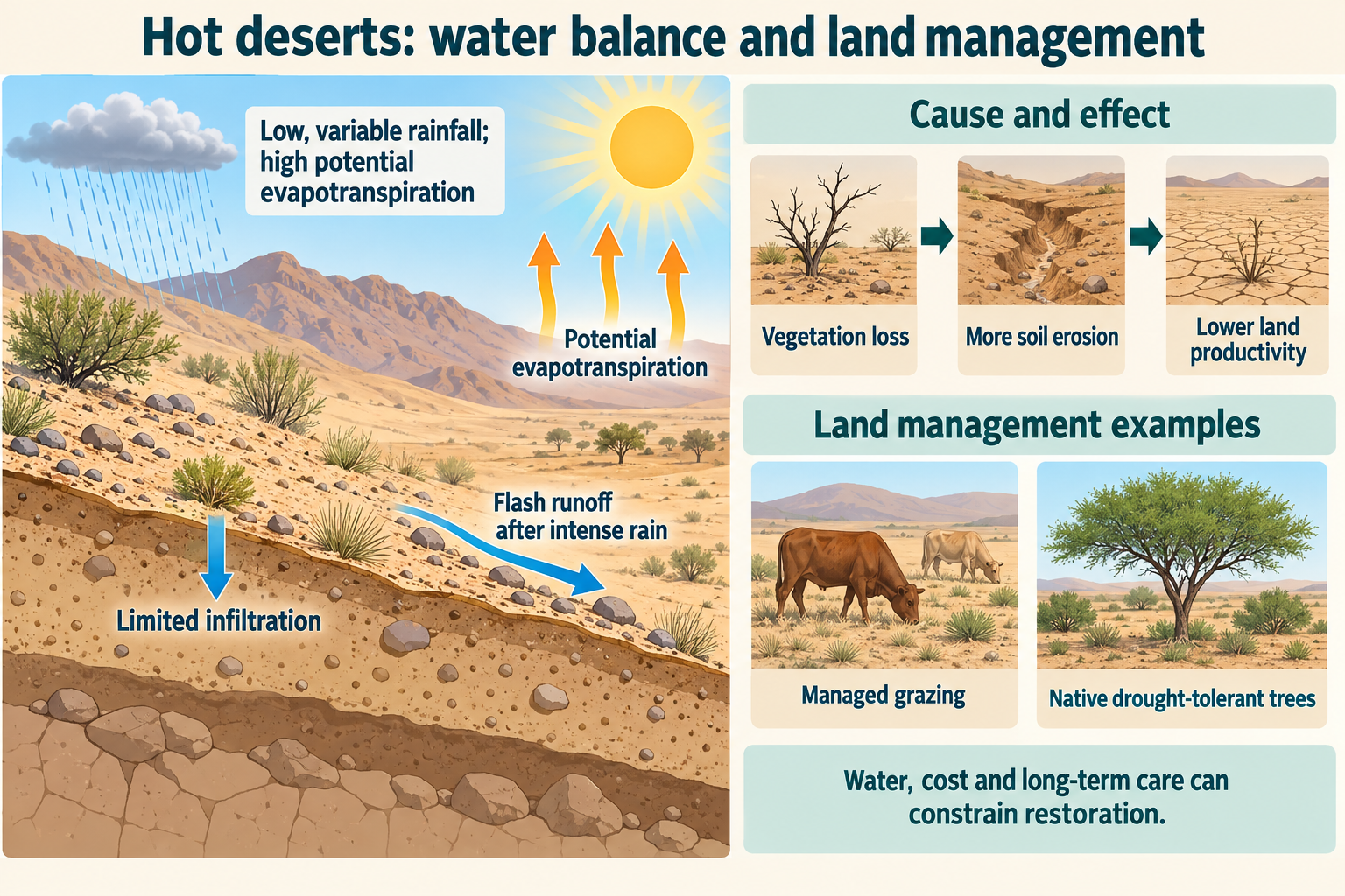
Sparse vegetation does not mean no life. Plants and animals cope with heat and water stress through physical features, behaviour, dormancy, migration and use of brief periods of moisture. Soil and surface cover influence how rainfall infiltrates, runs off or is lost to evaporation. When people use fragile dryland soils faster than they can recover, vegetation cover may decline, erosion can accelerate, and land productivity may fall.
People develop desert regions for minerals, energy, farming and tourism, but each use depends on access to water, transport, investment and technology. The same development may improve incomes and services while adding pressure to scarce water, soils or habitats. Sustainable management must match the local environment and involve the people who depend on it.
1. What is a hot desert?
A desert is an area with very low precipitation relative to potential evaporation. Definitions vary by dataset and climate classification, but aridity and limited water availability are central. Some deserts are hot for much of the year; others have cold winters or high elevations. This guide focuses on hot deserts, while recognising that temperature range and rainfall timing vary.
The word “desert” is often imagined as a continuous sea of sand. In reality, deserts include rock plateaus, gravel plains, dunes, salt flats, dry valleys, seasonal rivers, oases, grassland and scrub. Vegetation may be sparse but highly adapted. Some plants grow only after rain and remain dormant as seeds during dry periods.
Global distribution
Many of the largest hot deserts occur around 20–30 degrees north and south of the Equator. This broad pattern is related to the global circulation of the atmosphere. Warm air rises in the tropics near the Equator; after losing moisture as rainfall, some air moves poleward and descends in subtropical high-pressure zones. Descending air warms, and relative humidity falls, reducing the likelihood of cloud and rain.
Not all deserts are at these latitudes. Continental interiors are far from moist ocean air; mountains can create rain shadows; and cold ocean currents can stabilise coastal air so that rainfall remains limited. Local topography and winds modify the broad pattern.
Examples include the Sahara in North Africa, the Arabian Desert in south-west Asia, the Thar in north-west India and Pakistan, the Atacama in South America, and the Australian deserts. Their climates, landforms and ecosystems are not identical.
Rainfall and aridity
Rainfall is usually low, variable between years, or concentrated in short events. A year with a low average can still contain a sudden storm. Intense rainfall over bare or hard ground can create rapid runoff, flash floods and erosion, even though annual precipitation is low.
Potential evapotranspiration is the amount of water that could evaporate and be transpired if sufficient water were available. In hot deserts, strong sunlight and high temperatures can make atmospheric water demand much greater than rainfall. The result is a persistent water deficit. Actual evaporation may be limited by the lack of water.
Some deserts experience a short wet season; others receive irregular rainfall. A climate graph shows monthly averages, but averages can hide extreme variability. Farmers and pastoralists may need to plan for both long dry spells and occasional heavy rain.
Temperature
Clear skies and dry air allow strong heating during the day and rapid heat loss at night. Daily temperature ranges can be large. Very high summer temperatures create heat stress, while winter nights in some deserts can fall near or below freezing. These changes influence when people work, which crops grow and how animals avoid heat.
The Thar includes large seasonal and daily variation. The Government of Rajasthan describes the north-western region as dry, with summer temperatures that can exceed 45°C and winter temperatures that can fall below freezing. Such figures refer to regional conditions and particular periods, not to every day across the whole desert.
2. Water, soil and desert landforms
Water is scarce but not absent. It may be stored in seasonal streams, shallow or deep groundwater, tanks, reservoirs, aquifers, oases, soil moisture and temporary pools. Access can be highly uneven. A settlement may be located around a reliable water source while nearby land remains too dry for regular cultivation.
Rainfall pathways
After a short storm, some water infiltrates into soil; some runs over the surface; some evaporates quickly; and some collects in depressions or flows through ephemeral channels. The proportions depend on slope, soil texture, vegetation, crusting and rainfall intensity.
Vegetation slows wind and runoff. Roots can stabilise soil and create pathways for infiltration. Litter and plant cover reduce direct raindrop impact. Where cover is sparse or removed, wind can move dry surface particles and intense rain can create rills or gullies.
Desert soils
Many desert soils have low organic matter because plant growth is limited and decomposition and nutrient inputs are small. Some soils are shallow, stony or saline; others can be fertile when water is available. Floodplains and irrigated land may support productive farming, while excessive irrigation in a hot climate can cause waterlogging or salt to accumulate at the surface.
Salinity develops when dissolved salts remain in soil water and evaporation removes the water. Irrigation can bring salts from groundwater or soil layers. If drainage is poor and more water is applied than can be removed, the water table may rise and salts may concentrate near the roots. The problem depends on water quality, irrigation practice, evaporation, soil and drainage.
Desert landforms
Wind can deflate loose particles and transport sand. Deposition creates dunes, whose shapes and movement depend on wind direction, sand supply and vegetation. In areas with vegetation, roots trap sediment and slow dunes. Gravel plains may form where wind removes finer material.
Running water also shapes deserts. Rare storms can erode channels and transport sediment in wadis or dry valleys. Alluvial fans may form where a steep channel reaches a flatter plain and loses energy. Oases can occur where groundwater reaches the surface or is brought up by wells.
Landforms are evidence of processes, but a single landform does not reveal the full climate history. Some desert landscapes were shaped under wetter past conditions; others are modified by modern storms and wind.
3. Desert ecosystems and interdependence
A desert ecosystem links climate, water, soil, plants, animals and people. Low and unreliable water availability is a major control, but local geology, elevation, shade, soil and human use create small habitats with different conditions.
Plants
Plant cover is often sparse, but many species have specific strategies for surviving drought:
- Water storage: succulents store water in stems or leaves.
- Reduced leaf area: small leaves, spines or leaves shed during drought can reduce water loss.
- Waxy surfaces: a cuticle can reduce evaporation from leaves and stems.
- Deep roots: some plants reach groundwater or deeper soil moisture.
- Wide shallow roots: others rapidly absorb brief rainfall across a large area near the surface.
- Dormancy: seeds may remain inactive during dry conditions and germinate after rainfall.
- Short life cycles: annual plants can grow, flower and set seed during a brief wet period.
- Salt tolerance: some species can tolerate saline soils or water.
These strategies have trade-offs. Deep roots require energy and may not reach water if groundwater falls. A plant that grows rapidly after rain may be vulnerable during a prolonged drought. Spines reduce leaf area and may deter some herbivores, but plants still need ways to capture carbon for photosynthesis.
Animals
Desert animals can avoid the hottest conditions by sheltering in burrows or shade, becoming active at night, or changing their activity with season and temperature. Some obtain water from food or metabolic processes, while others travel to water sources. Reptiles may use behaviour to regulate body temperature; mammals may reduce water loss through physiological processes.
Camouflage can help animals avoid predators or approach prey. Large ears or other exposed body surfaces can help some animals lose heat, but this is not universal. Some animals migrate seasonally; others remain in small territories and tolerate long periods with little surface water.
Adaptations need to be described accurately. “The animal stores water” is not a safe generalisation unless a species and evidence support it. Many desert animals conserve water, obtain it through food or behaviour, and use sheltered microhabitats rather than carrying a large store.
Interdependence
Plants provide food, shade and shelter. Herbivores eat leaves, seeds or roots; predators feed on herbivores; decomposers break down waste and dead material. Rainfall influences plant growth, which affects food availability for animals and people.
Vegetation also changes soil and water movement. Roots bind soil; shade lowers surface temperatures; plant cover traps windblown sediment and reduces runoff. If plants are removed, soil may erode more quickly and retain less moisture. This can make it harder for vegetation to recover.
Human activities are part of the system. Livestock graze plants; fuelwood collection removes vegetation; wells and canals redistribute water; farms change soil cover; and roads fragment habitats. The outcomes depend on how much is used, how quickly vegetation recovers, and whether management matches local rainfall and soil conditions.
4. Biodiversity and conservation
Deserts can support unique biodiversity despite low vegetation cover. Species may be adapted to rare water, extreme temperatures and seasonal food. Isolated mountains, wadis, springs and oases can support distinct communities. Some species are highly specialised and vulnerable to habitat change.
Threats include overgrazing, conversion to farms or settlements, mining, roads, water extraction, pollution, tourism disturbance and climate change. Development may fragment habitats, disturb breeding areas or alter groundwater. Off-road vehicles can damage slow-growing vegetation and compact soil.
Conservation can protect sensitive habitats, restrict damaging vehicle use, maintain migration routes and monitor rare species. Water extraction rules can protect springs and wetlands. Community participation matters where residents depend on grazing, fuelwood or seasonal water. Protected status without resources or local support may not prevent degradation.
Biodiversity is also an opportunity. Desert species can provide genetic resources, pollination, soil stability and cultural value. Their survival depends on maintaining whole processes, not only fencing a few animals from people.
Place example
The Thar Desert in Rajasthan is the named development example. The Sahel is a separate, illustrative dryland-margin example for desertification. Use your teacher’s chosen places if the school case studies differ.
5. Thar Desert case study: Rajasthan, India
The Thar Desert crosses north-west India and eastern Pakistan. This guide focuses on Rajasthan, where the north-western part of the state is sandy and dry. The Aravalli Range lies roughly parallel to the moisture-bearing south-west monsoon winds, so it does not force much of that air to rise over the north-western desert region. Rajasthan’s official profile reports average annual rainfall below 400 millimetres in much of this north-western region, with high summer and cold winter extremes.
The Thar is inhabited and used. Rural communities practise livestock keeping and farming; towns provide services, trade and tourism; mining and energy projects connect the region to national markets. Water sources include wells, tanks, rivers that flow seasonally, and the Indira Gandhi Canal system. Opportunities and challenges vary between districts and between places near a road or canal and remote settlements.
Mineral extraction
Rajasthan has a significant mineral-based economy. State sources identify gypsum, limestone, copper, silver, rock phosphate and other minerals among its resources. Mining and quarrying provide materials for construction and industry, employment and state revenue. Some mineral deposits are located in or near dryland districts, including areas around Jaisalmer.
Mineral extraction can require roads, processing plants, water, energy and waste storage. Open-pit mining removes soil and vegetation, can fragment habitats and creates dust. Mine drainage or poorly managed waste can affect water quality. The benefits may be concentrated among firms, workers and public budgets, while nearby communities experience traffic, land-use change or pollution.
Management can reduce impacts through environmental assessment, limits on extraction, water recycling, dust control, safe tailings, rehabilitation and post-mining land restoration. Monitoring and enforcement determine whether rules change outcomes.
Energy production
The Thar and western Rajasthan have high solar potential because of strong sunlight and extensive open landscapes. Large solar installations convert solar energy into electricity and can support India’s electricity supply and lower-carbon development. The Indian Ministry of New and Renewable Energy described Bhadla Solar Park in Rajasthan as a 2.25-gigawatt solar park in a 2024 publication.
Solar power can create construction and maintenance jobs, attract investment and provide electricity to homes and industry. However, a large solar park occupies land, changes habitat and requires roads, transmission lines, panels, cleaning and grid connections. In a dry region, panel cleaning can require water; projects need to plan for water supply and avoid sensitive habitats or important grazing land.
Wind power is also part of Rajasthan’s energy sector. Renewable energy reduces emissions during electricity generation compared with burning fossil fuels, but land and transmission impacts remain. A fair evaluation compares climate benefits and energy access with local land use, water, ecology and employment.
Farming and pastoralism
Agriculture in Rajasthan includes drought-tolerant crops such as pearl millet, barley and pulses, as well as irrigated crops in areas with canal or groundwater access. Livestock keeping is important in many dryland livelihoods. Mixed farming can spread risk: animals may provide milk, meat, wool, income and manure; crops provide food and fodder.
The Indira Gandhi Canal brings water to north-western Rajasthan and supports drinking supplies and irrigation. Water can make cultivation possible where rainfall is unreliable, support higher yields and reduce drought risk. The canal has also changed land use and local ecology.
Irrigation must be managed carefully. Canal seepage and excessive or poorly drained irrigation can raise groundwater and contribute to waterlogging and soil salinity. Evaporation leaves salts behind; waterlogged roots may lack oxygen; crop yields can decline. Canal rehabilitation, lining, drainage, efficient irrigation, crop choice and water allocation can improve efficiency, but each option has costs and distributional effects.
Rain-fed farmers remain exposed to changing monsoon timing and drought. Rainwater harvesting, tanks, farm ponds, soil bunds, mulch, mixed crops, seed varieties and livestock care can improve resilience. The most appropriate practice depends on land tenure, labour, cost, local knowledge and the reliability of rainfall.
Tourism
Jaisalmer is a historic city close to the Thar and near the Pakistan border. Its fort, havelis, desert landscapes and cultural attractions draw domestic and international visitors. Tourism can support guides, transport, hotels, restaurants, artisans and local businesses. It may increase income without extracting minerals or clearing large areas for farming.
Tourism can also be uneven. Jobs may be seasonal, profits may go to outside operators, and visitors may use water and energy in a region where both are limited. New roads, hotels, waste and vehicle traffic can damage dunes or disturb wildlife. Popular sites may become crowded while remote settlements receive few benefits.
Responsible tourism can use local ownership, visitor limits in sensitive habitats, waste management, water-efficient accommodation, trained local guides and conservation contributions. Tourism should not be assumed to replace other livelihoods or protect the whole desert.
Challenges to development
Extreme temperatures make outdoor work difficult and can harm health. Construction, mining and farming may need to adjust work hours, provide shade and water, and protect workers during heat. Summer heat can increase demand for cooling and electricity.
Water supply is a major constraint. Rainfall is low and unreliable, groundwater can be deep or saline, and local rivers may flow only seasonally. Farms, towns, industry, mining, tourism and ecosystems compete for water. Canal water improves supply in some locations but cannot meet every need without careful allocation and maintenance.
Inaccessibility raises the cost of development. Long distances, sparse settlement, heat, shifting sands and limited roads can make it expensive to transport workers, goods and services. Roads can improve access but also fragment habitat and make fragile land easier to exploit.
These challenges interact. A remote mine may require a long road, reliable water and a power connection; providing those services raises costs and environmental impact. A tourist hub can prosper while villages beyond it remain less connected. Development is therefore spatially uneven.
Assessing opportunities and challenges in the Thar
The Thar offers mineral, energy, farming and tourism opportunities, but these do not have equal importance everywhere. Solar and wind resources can attract large investment; mining can generate revenue and jobs; canals can support agriculture; and Jaisalmer can attract visitors. Extreme heat, water scarcity and poor access raise costs and can limit who benefits.
The most important constraint depends on the activity. Water may be the decisive limit for irrigated farming; transport can be decisive for a remote mine; worker heat exposure affects construction and tourism; grid access matters for renewable electricity. An answer should identify the activity and place before ranking challenges.
Benefits depend on local jobs, community consultation, ownership, services and environmental safeguards. A new road or canal can improve living standards while creating secondary impacts. “Development” should be assessed by who gains, who pays, how long benefits last and whether the land and water remain usable.
6. Desertification
Desertification is land degradation in arid, semi-arid and dry sub-humid regions resulting from several factors, including climate variability and human activities. It is not simply a natural desert advancing in a straight line over a fertile region. It describes declining land condition or productivity in drylands, which can involve soil erosion, loss of vegetation, salinity, reduced soil organic matter and changing water conditions.
A drought is a period of below-average rainfall or water availability. It may be temporary. Desertification is a longer-term process of land degradation that can be worsened by repeated drought and unsustainable use. A drought can therefore contribute to desertification risk, but the two terms do not mean the same thing.
Desertification risk on desert margins
The fringes of hot deserts are often semi-arid. Rainfall is low and variable, but enough may fall in some years to support crops, grazing and trees. This makes the area valuable for food and livelihoods, but vulnerable to pressure if people or livestock rely on vegetation that grows slowly or inconsistently.
The Sahel stretches across Africa south of the Sahara. It includes a wide range of climates, soils, cultures, economies and land-use systems. It should not be represented as a uniform zone where people use land in the same way. Both dry periods and wetter periods occur, and vegetation responds to rainfall variability.
Climate variability and climate change
Rainfall variability can reduce plant growth and water availability. Prolonged drought may lower crop yields, reduce pasture and force livestock to travel farther. Higher temperatures can increase evaporation and water demand. Climate change may alter heat and rainfall risks in some dryland regions, but the pattern varies and local land use also matters.
Climate is not the only driver. A dry year does not automatically cause permanent degradation if soils remain covered, grazing is managed and recovery time is available. The same drought can have different effects depending on vegetation, land rights, poverty, infrastructure and access to support.
Population growth and resource demand
Population growth can increase demand for food, fuelwood, water, housing and grazing. If the amount of available land and water does not increase, pressure may intensify. However, population is not a standalone explanation: technology, market access, distribution, policy, household income and land ownership influence how demand translates into land use.
People may move into marginal land when fertile areas are owned, degraded or unavailable. Migration can add pressure at a receiving location, but it can also be a strategy that spreads household risk and income. Avoid blaming people facing poverty or displacement without considering the wider choices and constraints.
Fuelwood removal
Fuelwood is used for cooking and heating where other energy sources are costly or unavailable. Repeated removal of shrubs and trees can reduce vegetation cover, expose soil to wind and water erosion, and limit future supply. Cutting branches or coppicing may be sustainable if plants regrow and collection is controlled; removing roots and whole trees is more damaging.
Providing efficient stoves, affordable clean energy, managed woodlots or alternative income can reduce pressure. Rules that simply ban fuelwood collection may harm households if no practical replacement exists.
Overgrazing
Livestock are essential to many dryland livelihoods. Grazing can use vegetation that people cannot eat, provide food and income, and transport nutrients. Overgrazing occurs when grazing pressure is too high for vegetation to recover in a given place and time.
If animals repeatedly eat seedlings and grasses before regrowth, plant cover may fall. Hooves can compact soil around water points, reducing infiltration. Bare soil is then exposed to wind and runoff. As pasture declines, herders may concentrate animals in remaining areas or travel farther, potentially increasing pressure elsewhere.
The problem is often linked to restricted routes, land tenure, fencing, drought, conflict, loss of communal grazing and limited access to water. Rotational grazing, negotiated access corridors, seasonal resting of pasture, fodder storage and reliable early warning can help, but rules must fit local mobility and rights.
Over-cultivation
Cultivation can degrade soil if crops are grown repeatedly without replenishing nutrients or allowing recovery. Ploughing removes protective vegetation and can break soil structure. Cultivation on steep slopes or during dry, windy periods increases erosion risk. A short fallow may not allow soil and vegetation to recover.
Farmers may intensify cultivation because population and market demand rise, land becomes scarce or households lack secure land elsewhere. Improved soil cover, crop rotations, intercropping, manure, compost, contour planting and appropriate fallow can reduce losses. Their use depends on labour, knowledge, seed, livestock and access to markets.
Soil erosion
Wind and water remove topsoil. Wind erosion is likely where dry, fine soil is exposed; water erosion can be intense during heavy rain on bare or sloping land. Soil loss reduces organic matter and nutrients and can clog water channels or reservoirs. Deposited sediment may harm fields, settlements and aquatic systems elsewhere.
Erosion is both a process and an impact of reduced cover. Once vegetation declines, erosion can remove seeds and fine soil, making regrowth more difficult. This feedback can reinforce degradation. If the soil is protected and rainfall returns, some vegetation can recover.
7. Reducing desertification risk
Strategies should retain water, protect soil, restore vegetation and support livelihoods. A measure should be judged by how it works in a particular soil and climate, who maintains it and whether it reduces pressure on land.
Water management
Rainwater harvesting collects short periods of rainfall for later use. Tanks, small reservoirs, bunds and lined storage can provide drinking water, livestock supplies or limited irrigation. Rooftop collection may work in settlements; contour bunds and small barriers can slow runoff in fields.
Efficient irrigation, drip systems, canal maintenance, leak reduction and careful scheduling can reduce water waste. Water allocation rules can protect household supply and ecosystem flows. Groundwater should be monitored so abstraction does not exceed recharge. Desalination or long-distance water transfers may supply towns or industry but can use significant energy, cost money and shift environmental impacts.
Soil management
Mulch and crop residues protect the soil surface from wind and raindrop impact and reduce evaporation. Contour ploughing follows the slope’s contour lines and slows runoff. Stone lines or bunds can trap sediment and water. Minimum tillage leaves more structure and cover. Rotational grazing gives vegetation time to regrow.
These methods can improve infiltration and reduce erosion, but must be maintained and adapted to local conditions. A poorly placed barrier can redirect runoff and cause erosion elsewhere. Crop residues may also be needed for animal fodder, so farmers face trade-offs.
Zai pits and half-moons in the Sahel
In some Sahelian communities, farmers use planting pits known as zai or crescent-shaped half-moon structures. The pits collect runoff, concentrate water and organic matter near seeds or seedlings, and improve infiltration. The technique can restore degraded patches and help crops or trees establish.
The method uses local knowledge and relatively simple tools, though labour requirements can be high. It works best when rainfall, soil and land slope are suitable and when farmers can protect seedlings from grazing. A tool or pit is not a universal solution; local adaptation and maintenance matter.
Tree planting and assisted natural regeneration
Trees and shrubs provide shade, wind protection, fodder, fruit, fuel, timber and soil stabilisation. Shelterbelts reduce wind speed; agroforestry integrates trees with crops; assisted natural regeneration protects existing seedlings and roots so vegetation can recover. Farmer-managed natural regeneration uses selected naturally regenerating trees within fields.
Tree planting can fail if species do not suit local rainfall, soil or grazing pressure. Seedlings need protection and water while establishing. Planting dense exotic trees can compete with crops or reduce groundwater. A successful scheme identifies locally useful species, provides community control, protects land rights and monitors survival beyond the first planting season.
The FAO reports examples in Niger where farmers use zai pits and assisted natural regeneration to capture water, protect vegetation and create livelihood products. These approaches combine traditional practice, local participation and support from restoration programmes.
Appropriate technology and livelihoods
Appropriate technology is affordable, repairable, suited to local skills and environmental conditions, and accessible to the people who need it. Examples include solar pumps, water storage, weather information, drought-tolerant seeds, efficient cooking stoves, small-scale drip irrigation and tools for soil restoration.
Technology can reduce labour or improve access, but can also increase pressure. A solar pump lowers the cost of water extraction; without groundwater rules, it may encourage over-pumping. Irrigation increases production but can cause salinity if drainage is poor. Appropriate use combines equipment with training, maintenance, finance, rights and monitoring.
Diversified livelihoods can reduce dependence on one crop or grazing area. Beekeeping, local crafts, drought-resilient livestock, processing and community tourism may create additional income. Alternatives must be viable and led with local communities rather than imposed from outside.
Community planning and climate resilience
Communities can map water sources, grazing routes, degraded areas and seasonal risk. Local agreements can coordinate grazing and fuelwood collection. Weather forecasts and drought early-warning systems can help households adjust planting or livestock movements.
Land restoration is more effective when residents help choose sites, methods and ownership. A project should state who controls the land after restoration and who receives the products. If benefits are captured by external investors while local users lose access, the intervention may be environmentally and socially unsustainable.
8. Evaluating desertification responses
Use the following questions to evaluate a strategy:
- Does it tackle the process causing degradation, such as runoff, soil exposure, excessive grazing or water loss?
- Is it suitable for rainfall reliability, soil type and land use?
- Can local people afford, maintain and repair it?
- Does it improve food, water or income security as well as vegetation cover?
- Could it restrict customary access or shift pressure to another area?
- How long will it take for the benefits to appear?
- What evidence shows that soils, productivity or vegetation are recovering?
A response can be effective at one scale and inadequate at another. A field bund protects one plot; a catchment plan coordinates many plots and water flows. A national tree-planting target may create seedlings, but local survival, species and rights determine whether it restores a functioning ecosystem.
Desertification is not solved by planting trees alone. Tree cover can stabilise soil and provide products, but grazing, farming, water availability, markets, tenure and drought also shape risk. Integrated strategies combine prevention, restoration, livelihood support and fair management.
9. The Thar: water access and development choices
Local water knowledge and storage
In a dry region, water infrastructure is not only a large canal. Households, villages and farms may use tanks, covered storage, wells, ponds, roof collection and seasonal runoff. Traditional rainwater harvesting can store short-lived monsoon rainfall for drinking, animals or small areas of cultivation. Some underground storage reduces evaporation compared with an open surface pond, although construction and maintenance still require materials and labour.
A water source has a catchment and a user network. A village tank may depend on runoff from a wider area; a well may draw from an aquifer shared by many users. If upstream land cover changes, sediment can fill storage structures. If too much groundwater is pumped, wells become less reliable. Planning should consider where water enters, how it is stored, who can draw it, and whether it is replenished.
Canal water can increase the amount of land farmed and make a crop calendar more reliable. It can also bring benefits to towns, livestock and industry. These effects depend on distribution: farms nearest a distributary may receive a different supply from remote villages; head-end and tail-end users can face different reliability. Repairing channels, measuring flows, reducing leaks and agreeing allocation rules can make supply fairer and more efficient.
Water-saving agriculture includes mulching, field levelling, drip or micro-irrigation where suitable, planting at the right time, reducing evaporation from canals and choosing crops matched to water availability. A new irrigation scheme should compare its expected yield with the cost of water delivery, energy, maintenance, drainage and the risk of salt accumulation. High-value crops can provide income but also raise exposure if their water needs exceed reliable supply.
Solar power and land-use trade-offs
The Thar’s strong sunlight is a major energy opportunity. Utility-scale solar power can use large arrays and connect them to the electricity grid. Distributed rooftop or community systems can support pumping, refrigeration, communications or lighting closer to users. These two approaches have different land and network needs.
Large parks need substantial connected land, substations and transmission lines. Siting can compete with grazing, wildlife habitat, settlement, military areas, cultural landscapes or future farming. Dust can settle on panels and reduce generation; cleaning uses water or labour, and the practical solution depends on local availability. End-of-life panels also require recycling or safe disposal.
A good planning process maps land use and sensitive habitats before selecting a site, consults residents and pastoralists, assesses cumulative impacts across several nearby projects, provides local jobs and shares economic benefits. Solar power is low-carbon during electricity generation, but a project can still be socially or ecologically unsustainable if decisions ignore local costs.
Farming and pastoralism as risk management
Smallholder farmers may combine crops with livestock because rainfall is uncertain. Millet and other drought-tolerant crops can survive conditions that would damage more water-demanding crops. Livestock can use vegetation on land that is not suitable for crops and may be sold when a household needs cash. Herders may move seasonally to find pasture and water.
Mobility is not a sign of poor land management. In variable climates, moving animals between seasonal pastures can prevent one site from being grazed continuously. Fencing and land conversion can block traditional routes and concentrate grazing around wells or settlements. Water infrastructure can support animals during drought, but if too many animals gather at one permanent point, trampling can remove vegetation and compact soil.
Resilience comes from options: mixed crops, fodder reserves, veterinary care, market information, savings, social networks, access to water and a range of income. A drought-resistant seed can help, but it cannot compensate for a long period without rain or lack of secure land. Policies should support households before crisis conditions force distress sales or migration.
Mining, tourism and unequal costs
Mineral projects can be assessed through a simple chain: deposit location → mine and access infrastructure → extraction and processing → jobs, revenue and material supply → effects on water, land and local communities. At each step, ask who has control and who receives value. A mine may employ local people but bring specialist workers from elsewhere. Royalties may fund public services, but benefits depend on transparent government and fair distribution.
Tourism depends on transport, services, accommodation and a healthy cultural or natural attraction. Jaisalmer’s fort is part of a living settlement as well as a heritage site. Visitors create income for some businesses but increase demand for water, waste collection and energy. Desert safaris can disturb dunes or wildlife when vehicles leave agreed routes. Local guiding, small businesses and conservation rules can retain more value in the region.
A development decision may have both benefits and opportunity costs. Land for a solar park cannot simultaneously be used in the same way for grazing; water used by a mine may be unavailable to another user; a new road can improve services and increase extraction pressure. Explain the specific trade-off rather than describing a project as simply good or bad.
10. The Sahel: a dryland-margin example
The Sahel is a broad semi-arid transition zone immediately south of the Sahara, stretching across parts of West and Central Africa. It is not a uniform strip with a fixed edge. Rainfall varies greatly between places and from year to year. Many households combine crops, livestock, trade, seasonal work and migration. Land use and rainfall patterns differ among countries and communities.
The Sahel illustrates why desertification should be explained as the interaction of environmental variability and human pressure. In a dry year, pasture and crop growth may be reduced. If a household has few alternative livelihoods, it may cultivate marginal land, cut shrubs for fuel or keep animals concentrated near a reliable water point. These responses can protect immediate survival. If repeated without recovery time, however, they can expose soil and weaken vegetation.
A causal chain for degradation
One possible chain is:
- Rainfall is delayed or lower than expected, reducing grass and crop growth.
- Livestock spend longer feeding in the remaining productive patches, or cultivation expands onto exposed soils.
- Plants are grazed or cleared faster than they regrow; roots and litter provide less soil cover.
- Wind removes dry fine material and intense storms wash bare soil into depressions and channels.
- The remaining soil stores less water and nutrients, so crops and pasture recover less reliably.
- Reduced harvests or fodder place pressure on household income and food security, increasing the need to use remaining resources.
This is a risk pathway, not a description of every Sahelian household. Management, rainfall, soils, markets, land access and government support can interrupt the chain at several points. A farmer may protect trees in fields, rotate crops and livestock, or move herds along negotiated routes. The environment is variable, and local knowledge helps people make decisions under uncertainty.
Causes in more detail
Climate variability can bring multi-year rainfall deficits. Climate change can intensify heat and alter rainfall risks, though projected precipitation changes differ among areas. Population growth can raise demand for food, fuelwood and grazing. Fuelwood collection removes shrubs and trees when regrowth is slow. Overgrazing can occur where animals cannot move or where stocking exceeds available pasture. Over-cultivation and continuous tillage can reduce organic matter and leave ground exposed. Soil erosion then removes the most productive surface material.
These causes can reinforce each other. Land insecurity may discourage investment in trees or soil improvements if residents are unsure they will remain. A road or market may raise prices for charcoal or crops, increasing pressure on vegetation. Poverty can limit a household’s ability to purchase alternative fuel or drought-resilient seed. Insecurity or conflict can restrict seasonal mobility and prevent land restoration. Solutions therefore need to address both physical processes and access to resources.
Impacts on people and the environment
Land degradation can lower crop yields and pasture quality, reduce soil moisture, increase dust and sediment, and make water sources less reliable. Households may need to spend more time collecting fuel and water. Livestock can lose condition, and farmers may face repeated crop failure. Some families migrate seasonally or permanently for work.
These impacts are not shared equally. Households with land, savings, irrigation or transport have more options than households dependent on a single rain-fed plot. Women and children may carry additional work when fuel or water sources are farther away. Land conflict can rise where grazing routes and cropland overlap. Avoid implying that environmental degradation inevitably causes conflict; governance, inequality and political conditions also shape outcomes.
11. Restoration methods in the Sahel
Zai pits and half-moons
Zai pits are small planting hollows dug in hard or degraded ground. They collect runoff and can concentrate manure or compost close to a seed. Insects and soil organisms may help create channels that improve infiltration. Half-moon structures are curved earth or stone barriers laid along contours; they capture runoff and sediment and slow water as it crosses the slope.
Both techniques aim to make limited rainfall more useful to plants and reduce rapid runoff. Their success depends on the slope, soil, rainfall, structure spacing, seed choice and maintenance. Constructing many pits requires labour, so groups may organise collective work or use suitable equipment. A single restored field can help a household; connected restoration can reduce erosion across a wider catchment.
Farmer-managed natural regeneration
Farmer-managed natural regeneration protects selected living stumps, roots and seedlings so trees and shrubs regrow among crops or pasture. Farmers choose useful species and manage stems through pruning, protection and coppicing. This can cost less than planting large numbers of seedlings and can build on locally adapted vegetation.
The practice requires access rights. If a farmer does not control the land or does not receive benefits from trees, there may be little incentive to protect them. Livestock need agreed access so young growth is not immediately eaten. The method can provide shade, fodder, fruit, fuelwood and soil protection, but it is not suitable identically everywhere.
Agroforestry and diversified incomes
Agroforestry combines trees with crops and/or livestock. Trees can provide shade, fodder, fruit, fuel and wind protection. Their roots can improve soil structure, and litter adds organic material. Some systems keep crops between tree rows; others integrate scattered trees into grazing land.
Diversification spreads risk. A household may combine crops, livestock, tree products, beekeeping, processing or seasonal work. This can reduce dependence on a single rainfall-sensitive harvest. Access to markets and storage matters: a surplus product only improves income if it can be transported, sold and fairly priced.
Appropriate technology and public support
Small-scale water storage, weather information, drought-resistant crops, efficient stoves and tools for soil restoration can reduce pressure. Public investment can support rural roads, veterinary services, grain storage, early warning and extension advice. Credit and insurance may help households recover after a drought, if costs and eligibility do not exclude the poorest groups.
A technology must fit available skills and maintenance. A pump that cannot be repaired locally may fail; a groundwater pump without extraction rules may deplete an aquifer; a tree nursery may produce species unsuited to the local soil. Projects should measure survival, yields, water levels and household access over time.
Evaluating the Great Green Wall and restoration programmes
The Great Green Wall is a continent-wide programme and political vision for restoring land and supporting livelihoods across the Sahel and neighbouring drylands. It includes a range of locally adapted restoration and development activities rather than one continuous wall of trees. The image of a fixed line of trees can mislead: drylands need mosaics of farms, grassland, shrubs, woodland and water management.
Large programmes can mobilise funding, technical support and international attention. Their results depend on national institutions, local participation, long-term maintenance, land rights and livelihood benefits. Targets should be checked against evidence of restored land condition and household outcomes, not just the number of seedlings distributed or hectares announced.
The FAO describes farmer practices in Niger such as zai pits, half-moons and assisted natural regeneration. These examples show how local knowledge can combine with public support. They do not prove that one technique will work across all countries or every soil type.
12. Comparing development and degradation questions
An exam question may ask you to assess whether a challenge is more important than another. Do not provide equal-length lists without judgement. Explain how each challenge limits a specific economic activity, then weigh the relative impact.
For the Thar, water scarcity may constrain irrigated farming more directly than inaccessibility, while a remote mine may be constrained more by transport and power connections. Extreme heat affects both, but can be managed through work schedules, shade and technology at additional cost. The strongest judgement is conditional: state which challenge matters most for which development and why.
For desertification, distinguish the immediate pressure from the underlying condition. Overgrazing may remove vegetation, but restricted grazing routes or lack of alternative fodder may make the pressure worse. Drought may reduce plant growth, but soil exposure depends on management and land cover. A response should address both levels.
When assessing a restoration strategy, make a balanced chain:
action → physical mechanism → ecological result → livelihood effect → limitation or trade-off.
For example, contour barriers slow runoff and trap sediment; this may increase soil moisture and plant establishment; better ground cover can support crops and fodder; but barriers need maintenance and land users must agree on their location. This process-based answer is stronger than saying “terracing is sustainable”.
13. Quick process diagrams
Hot desert climate
Strong heating at low latitudes → rising air near the Equator loses moisture → dry air moves poleward and descends in subtropical zones → pressure rises and clouds are limited → rainfall is scarce and unreliable.
Desert ecosystem
Low rainfall and high evaporation → limited soil moisture → sparse or seasonal plant growth → specialised feeding and water-saving strategies → human use concentrates near dependable water and access routes.
Desertification risk
Drought or rainfall variability + high resource demand → vegetation removal or insufficient recovery → exposed or compacted soil → wind and water erosion → lower soil moisture, nutrients and productivity → greater livelihood pressure.
Restoration
Slow runoff and capture water + protect vegetation + improve soil cover + support viable livelihoods → greater infiltration and reduced erosion risk → better conditions for plant recovery and production, if maintenance and land access continue.
These are simplified models. Use the process that matches the place and evidence in the question.
Maps, data and evidence
Reading a climate graph
A desert climate graph should be read month by month. Compare temperature and rainfall, note when the hottest period occurs, and identify whether rain is absent throughout the year or concentrated in a short season. Annual rainfall alone may conceal a period critical to plant growth.
If comparing two deserts, use the same units and date range. A coastal desert influenced by a cold current may have different temperatures and fog than an inland desert at a similar latitude. A mountain rain shadow may receive rain on one side and little on the other.
Mapping land degradation
Satellite data can track vegetation cover, bare soil, fires and land-use change across a wide region. Field measurements can check soil depth, plant cover, infiltration and erosion. Rainfall records and local knowledge help distinguish a temporary drought from a longer land-use change.
Desertification is complex, so no single map or indicator tells the whole story. A decline in vegetation could follow seasonal drought, harvesting, grazing, fire or conversion. Compare multiple indicators and periods. Specify what each dataset measures and its limits.
Data for the Thar case study
The Rajasthan government profile describes parts of north-western Rajasthan as receiving less than 400 millimetres of rain in an average year, with summer temperatures above 45°C and winter temperatures that can fall below freezing. These regional averages and extremes explain why water and temperature challenge development.
The Indian Ministry of New and Renewable Energy’s 2024 publication described Bhadla Solar Park at 2.25 gigawatts. Attach the source date to this capacity because installed generation changes over time. The Rajasthan government identifies mineral-based and agriculture-based industries and the Indira Gandhi Canal as important regional features.
Use data to support a point, then explain the process. “Rainfall is low” is a fact. “Low, unreliable rainfall limits rain-fed farming, increasing dependence on drought-tolerant crops, livestock, water storage or irrigation” is an explanation.
Common misconception
Desertification does not mean the natural desert boundary simply moves outward every year. It means land degradation in drylands caused by interacting climate and human factors.
A drought is not automatically desertification. Drought may be temporary; desertification is longer-term land degradation, although repeated drought can worsen it.
Not every dryland resident or pastoralist causes overgrazing. Livestock support food and livelihoods; the balance depends on stocking, mobility, rainfall, tenure and recovery time.
More water is not always a sustainable answer. Irrigation can increase yields but may deplete aquifers, cause waterlogging or leave salts in soils.
Hot deserts are not empty, lifeless or all covered in sand. They contain adapted species, settlements, routes, livelihoods and varied landforms.
Solar panels are low-carbon in operation but not impact-free. Their sites still need land, water for cleaning, materials, transmission and ecological safeguards.
Tree planting is not always helpful if species, water use, land rights and grazing are ignored. Assisted natural regeneration or native species may be more suitable.
An increase in agricultural output is not automatically development for everyone. Consider water access, land tenure, prices, jobs, health, risk and long-term soil condition.
Key vocabulary
| Term | Meaning |
|---|---|
| Appropriate technology | Technology suited to local needs, resources, skills, cost and environmental conditions |
| Aridity | Long-term lack of water because precipitation is low relative to evaporation demand |
| Desertification | Land degradation in arid, semi-arid and dry sub-humid areas from climatic and human factors |
| Drought | A period of below-average rainfall or water availability |
| Evapotranspiration | Combined water loss through evaporation and plant transpiration |
| Half-moon | Curved earth or stone structure that captures runoff for soil restoration or planting |
| Interdependence | Links through which organisms and environmental conditions rely on or affect each other |
| Over-cultivation | Growing crops too frequently or intensively for soil and vegetation to recover |
| Overgrazing | Grazing pressure greater than vegetation can recover from in the available time and area |
| Rainwater harvesting | Collection and storage of rainfall or runoff for later use |
| Salinisation | Accumulation of soluble salts in soil, often linked to evaporation and poor drainage |
| Semi-arid | Dry climate with more rainfall than an arid desert, but still limited and variable water |
| Soil erosion | Removal and transport of soil by wind or water |
| Subsistence | Production mainly for household or local livelihood needs |
| Thar Desert | Hot desert region across north-west India and eastern Pakistan |
| Zai pit | Planting hollow that concentrates water and organic material in dryland soils |
Self-check
Answer from memory, then check the short guide. Use place detail and causal chains for extended responses.
- Where are many of the world’s hot deserts located?
- Explain how descending air in a subtropical high-pressure zone reduces rainfall.
- Why can annual rainfall hide important differences between two deserts?
- Explain one reason that desert surface temperatures can vary greatly between day and night.
- Name three desert landforms or surface types besides sand dunes.
- Give two ways water is stored or accessed in hot deserts.
- Describe two plant adaptations and connect each to water stress.
- Describe two animal behaviours that help avoid heat or water loss.
- Explain how sparse plant cover can affect soil erosion.
- What is the difference between potential and actual evapotranspiration?
- Describe the location and climate of the Thar Desert case study.
- Give one opportunity from mineral extraction and one related challenge.
- Explain how solar energy creates a development opportunity in western Rajasthan.
- State the reported capacity of Bhadla Solar Park in the 2024 MNRE publication.
- Explain one advantage and one drawback of the Indira Gandhi Canal.
- How can irrigation lead to soil salinity?
- Give two tourism benefits and two possible impacts in the Thar.
- Explain how extreme temperatures and inaccessibility affect development.
- Define desertification and distinguish it from drought.
- Explain how population growth can increase desertification pressure.
- How can removing fuelwood increase soil erosion?
- What is overgrazing, and why should it not be used to blame all pastoralists?
- Trace how over-cultivation can reduce soil productivity.
- Name three strategies to manage soil and water in semi-arid areas.
- How do zai pits or half-moons help restore dryland soils?
- Explain one way tree planting can fail in a dry region.
- Why might a solar-powered water pump need groundwater rules?
- What evidence could help distinguish a temporary drought from longer-term land degradation?
- Explain why desertification strategies need local participation.
- Assess why there is no single solution to desertification.
Short answer guide
- Broadly around 20–30 degrees north and south, with other deserts in interiors, rain shadows and coastal locations.
- Descending air warms and dries, limiting condensation, clouds and precipitation.
- Rain may fall in a short season at one site but be more evenly spread at another; timing affects plants and farming.
- Clear dry air allows strong daytime solar heating and rapid night-time heat loss.
- Examples include rock plateau, gravel plain, salt flat, dry valley, alluvial fan or oasis.
- Groundwater, wells, tanks, reservoirs, seasonal rivers, soil moisture, oases or seasonal pools.
- Reduced leaf area or wax reduces water loss; deep or spreading roots access scarce water; dormancy avoids dry periods.
- Nocturnal activity, burrowing, sheltering in shade, migration or using behavioural and physiological water-saving strategies.
- Less cover leaves soil exposed to wind and raindrop impact, increasing particle movement and runoff.
- Potential is atmospheric water demand if enough water is available; actual is what evaporates and transpires under real water supply.
- It spans north-west India and eastern Pakistan; the Rajasthan case has low, variable rainfall, hot summers and cold winter periods.
- It supplies minerals, employment or revenue; mining can remove habitat, use water, create dust or affect land and water quality.
- Strong sunlight supports utility-scale electricity generation and employment, although land, water, materials and transmission need management.
- 2.25 gigawatts, as reported in a 2024 publication. State the source date.
- It supplies drinking and irrigation water; excessive or poorly drained irrigation may cause seepage, waterlogging or salinity.
- Irrigation water carries dissolved salts; evaporation removes water and leaves salts in soil, especially if drainage is poor.
- It creates jobs and income; it may also increase water use, waste, congestion, habitat disturbance or unequal profits.
- Heat affects health and work; remoteness raises transport and service costs and makes infrastructure expensive.
- It is land degradation in drylands from climatic and human factors; drought is a period of low water availability and may be temporary.
- More people may need food, fuelwood, grazing, water and housing, increasing land pressure if access and resources are limited.
- Removing shrubs and trees reduces cover and roots, exposing the surface to wind and water erosion.
- It is grazing pressure faster than vegetation can recover. Livestock are important livelihoods; pressure depends on mobility, stocking, rainfall, tenure and alternatives.
- Repeated cropping and soil disturbance without recovery or nutrient replacement reduce cover and soil structure, making erosion and nutrient loss more likely.
- Water harvesting, contour bunds, mulch, rotational grazing, efficient irrigation, tree cover, soil barriers or groundwater monitoring.
- They capture runoff and concentrate water and organic matter near seeds, improving infiltration and plant establishment.
- Seedlings may lack water, be grazed, use unsuitable species, compete with crops or be planted without local rights and maintenance.
- Cheaper pumping can increase extraction beyond recharge, reducing water for households, other users and ecosystems.
- Compare repeated rainfall, vegetation, soil cover, soil organic matter, productivity, land use, erosion and local knowledge across several years.
- Residents know local conditions and depend on the land; participation makes methods practical, fair and more likely to be maintained.
- Rainfall, soils, livelihoods, grazing, cultivation, tenure and markets vary. A combination of water and soil management, vegetation recovery, technology, rights and livelihood support is needed.
Revision points
- Explain desert distribution through circulation, continentality, rain shadows or ocean currents, not simply latitude.
- Link low and unreliable rainfall with high water demand, sparse cover, soil vulnerability and adapted organisms.
- Connect each adaptation to a physical condition and state its trade-off or limit where useful.
- In the Thar case study, assess minerals, energy, farming and tourism alongside heat, water and access.
- Attach dates and sources to case figures, including the Bhadla capacity.
- Explain desertification as dryland degradation, not as a moving desert edge or another word for drought.
- Trace causes through process chains: pressure → vegetation or soil change → erosion or lower productivity → livelihood effect.
- Compare water and soil management, tree planting and technology in terms of local suitability, cost, maintenance and rights.
- Do not imply one technique or one community can solve a problem driven by climate, markets, land access and policy together.
Curriculum alignment
- Curriculum coverage ID: aqa.3.1.2.hot-deserts
- Related practice packs: gcse_geo_p1_physical_environment_june_2022, gcse_geo_p1_physical_environment_june_2023, gcse_geo_p1_physical_environment_june_2024, gcse_geo_p1_physical_environment_november_2020, gcse_geo_p1_physical_environment_november_2021
- Shared concept tags: hot-deserts, desertification, adaptation, development-options, drylands, water-management, soil-erosion
Sources and further reading
- AQA GCSE Geography 8035, Living with the physical environment: Specification content
- AQA: GCSE Geography command words
- Government of Rajasthan: Rajasthan at a glance
- Rajasthan Tourism: Jaisalmer
- Rajasthan Department of Mines and Geology: Mines and minerals
- Ministry of New and Renewable Energy, Government of India: Akshay Urja, September 2024
- Press Information Bureau, Government of India: Water for the Thar and Rajasthan Canal
- Press Information Bureau: Rajasthan water-sector restructuring and the Indira Gandhi Canal
- FAO: Desertification definition and dryland degradation
- UNCCD: Land degradation in the Sahel and sustainable land management
- FAO: Zai pits and assisted natural regeneration in Niger
- FAO: Bringing degraded African land back to life
- FAO: Regreening Africa and farmer-managed natural regeneration
- Government of Rajasthan: Environment Policy and desertification measures
The Thar and Sahel are illustrative examples. Reported climate conditions, energy capacity and development activity refer to a stated source date or regional scale; use current evidence supplied by your teacher or examination when it differs.