 FoxChild@Learn
8. Cold environments — school option
Curriculum status: Optional school choice. Choose either hot deserts or cold environments.
This guide follows AQA GCSE Geography 8035. Named examples below are suggested teaching examples where the specification allows a school choice; use your teacher’s selected case study and verify current figures before an assessment.
Required knowledge
- Describe polar and tundra conditions and links among climate, permafrost, soils, plants, animals and people; explain adaptations and biodiversity issues.
- Use a named cold-environment case study to assess mineral/energy extraction, fishing and tourism against extreme temperature, inaccessibility and infrastructure costs.
- Evaluate how fragile cold environments can be protected while balancing development and conservation through technology, government, international agreements and conservation groups.
What this optional chapter is for
AQA schools choose either hot deserts or cold environments for this part of the physical geography course. This library contains both routes so a teacher can use the one their class studies. If your school studies hot deserts, you can still read this chapter for interest, but do not assume that every detail is required for your examination. The specification asks you to understand a cold environment as an interacting system, examine its value and vulnerability, and weigh development opportunities against challenges and protection.
This chapter uses Arctic Alaska as a suggested case study. It is not the only suitable example. Replace the place evidence with the named place taught by your school if it differs. In the Arctic, local conditions vary sharply between the coast, mountains, forests and communities; an accurate answer names the location and scale it is describing.
The central geographical question is not simply whether people should use or protect a cold environment. It is how decisions can respond to uneven benefits, costs, rights and risks over time. Oil revenue, food security, jobs, wildlife, cultural continuity and global climate are not interchangeable measures. A strong evaluation identifies who gains, who bears risk, what is reversible, what is uncertain, and which decisions can still be changed.
Key vocabulary
| Term | Meaning |
|---|---|
| permafrost | Ground that remains at or below 0°C for at least two consecutive years. It is a thermal definition; it may contain ice, rock, soil or sediment. |
| active layer | The near-surface layer above permafrost that thaws in summer and freezes again in winter. Its thickness varies by soil, vegetation, snow, slope and weather. |
| tundra | A cold biome with low-growing vegetation and little or no continuous tree cover, commonly because of temperature, short growing seasons, waterlogged soils or exposure. |
| polar environment | A very cold high-latitude environment, often with ice, snow, permafrost or sparse vegetation. “Polar” does not mean every surface is permanently covered by ice. |
| cryosphere | The parts of Earth where water is frozen, including snow, sea ice, glaciers, ice sheets and permafrost. |
| thermokarst | Uneven ground, hollows, ponds or slumps formed when ice-rich permafrost thaws and the surface subsides. |
| solifluction | Slow downslope movement of waterlogged soil over a frozen or impermeable layer during thaw. |
| freeze–thaw weathering | Physical weathering in which water enters cracks, freezes and expands, then thaws; repeated cycles can widen the cracks. |
| active-season window | The short part of the year when temperatures and ground conditions allow particular ecological processes or construction activities. |
| subsistence | Harvesting and sharing food and materials for household or community use, closely linked to livelihoods, knowledge and cultural practice. |
| wilderness value | Ecological, cultural, scientific and experiential value associated with places with relatively little industrial infrastructure. It does not mean that nobody lives there. |
| environmental impact assessment (EIA) | A process that identifies likely environmental and social effects of a proposed development, considers alternatives and mitigation, and informs a decision. |
| cumulative impact | The combined effect of multiple pressures through time or across an area, which may be greater than the effect of one project considered alone. |
| landscape fragmentation | Breaking a habitat or ecological route into smaller, more isolated areas, for example by roads, pipelines, buildings or repeated human disturbance. |
| resilience | The ability of a system or community to absorb disturbance, adapt and continue key functions; it does not mean being unaffected. |
How the geography works
Latitude, sunlight and seasonality
At high latitudes, the Sun follows a low apparent path across the sky. In winter, some places receive very little direct sunlight or experience polar night; in summer, very long daylight or midnight sun can occur. This does not make every Arctic day equally cold or every summer equally warm. Clouds, sea ice, elevation, distance from the ocean, prevailing air masses and snow cover modify local conditions.
The annual pattern of available solar energy creates strong seasonality. A short summer growing season must support germination, flowering, pollination, seed production and the storage of energy for winter. Plants that grow slowly can take many years to recover after trampling or vehicle damage. Animals may time migration and breeding to the brief seasonal peak in food. A change of only a few weeks in snowmelt or sea-ice season can therefore affect many linked processes.
Polar tundra and alpine tundra are not identical. Arctic tundra lies at high latitude and may grade southwards into boreal forest. Alpine tundra lies above the climatic tree line on mountains at lower latitudes. Both can be cold, exposed and low in woody vegetation, but their day length, regional weather and species differ. In an answer, define which type you mean.
Permafrost, the active layer and drainage
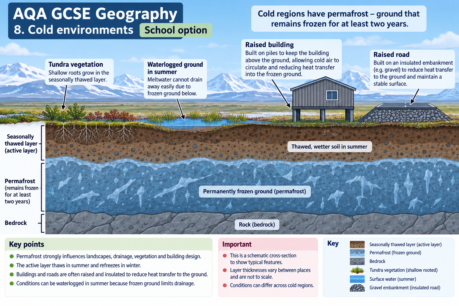
Permafrost is ground that remains at or below freezing for at least two consecutive years. It can be continuous across almost all a region, discontinuous beneath large patches, or present only in isolated places. A shaded north-facing slope, a windswept ridge and a snow-filled hollow can have different ground temperatures only a short distance apart. Snow insulates the ground in winter; vegetation shades it in summer; soil moisture and organic matter affect how heat moves.
Above the permafrost, the active layer normally thaws in summer and refreezes in winter. Where frozen ground prevents water from draining downwards, rain and snowmelt can saturate the active layer. This can produce boggy or ponded terrain in summer. A frozen layer can consequently restrict drainage while also storing large quantities of water and ice. The exact response depends on topography and whether water can run laterally to a stream.
When ice-rich permafrost thaws, the ground can lose volume and subside. The uneven surface may develop thermokarst hollows or ponds. On a slope, saturated soil can move downslope as solifluction; if ground ice melts rapidly, a slump or landslide can occur. A road embankment, building foundation or pipeline support may then settle unevenly. Thaw does not produce the same result everywhere: ice-poor gravel may remain comparatively stable, while an ice-rich slope can change substantially.
The active layer is also an ecosystem zone. Roots are generally shallow where frozen ground restricts depth. Microbes decompose organic material during warmer periods, releasing nutrients and carbon dioxide; waterlogging can create low-oxygen conditions where methane is produced. Freeze–thaw timing changes which nutrients become available and when streams receive meltwater. Thus ground temperature links landforms, hydrology, vegetation, greenhouse gases and people.
Soils and vegetation
Cold soils often have slow rates of chemical weathering and decomposition. Organic matter may accumulate because plant litter decomposes slowly, although decomposition can accelerate when soils become warmer and wetter. Waterlogged, poorly drained soils can have different oxygen and nutrient conditions from dry, windswept slopes. “Tundra soil” is not one uniform soil type.
Plants cope with cold, wind, a short season and sometimes nutrient-poor or waterlogged ground. Many grow close to the surface, where snow can insulate them from the harshest winter winds. Small leaves reduce exposure and water loss; dark pigmentation may help absorb energy; flexible stems resist wind; shallow roots use the seasonally thawed layer. Some plants spread by rhizomes or other vegetative methods, so a population can persist even when seed production is unreliable. These adaptations are responses to conditions, not purposeful decisions by individual plants.
Mosses, lichens, grasses, sedges, dwarf shrubs and flowering plants can coexist in mosaics. The distribution of plant communities reflects drainage, slope, soil, snow persistence, grazing and disturbance. Shrubs may become taller or more widespread where warming lengthens the growing season, but there can also be browning, wildfire, erosion or damage to ground conditions. A warmer mean temperature does not guarantee a uniform increase in plant growth.
Animals and interdependence
Cold-environment animals use a range of adaptations. Thick fur or feathers, insulating fat, compact shapes, seasonal coats, migration, hibernation, stored food, burrowing and behavioural changes can reduce the cost of cold. A polar bear’s large body and insulation help conserve heat; an Arctic fox changes coat colour seasonally; migratory birds exploit summer food and daylight; caribou move over long distances between seasonal ranges. Species do not all respond in the same way, and an adaptation that helps in one season may impose a cost in another.
Food webs link tundra plants, herbivores, predators, scavengers and decomposers. For example, lichens and other plants support grazing animals; caribou can provide food for predators and people; insects and plants support migratory birds; decomposers return nutrients to soil. Sea-ice-dependent marine mammals connect the ocean and coast, while river systems connect uplands with estuaries. Changes in the timing of snowmelt, sea ice or insect emergence can create a mismatch between a species’ breeding period and its food supply.
Interdependence also includes people. Indigenous communities have developed place-based knowledge, seasonal practices and harvesting systems over generations. A migrating animal may be simultaneously part of an ecosystem, a food source and a cultural relationship. Treating the environment only as a store of minerals ignores this wider geography. At the same time, communities are not identical in their views: residents may differ over development, employment, environmental risk and desired futures.
Sea ice, snow and seasonal habitats
Cold land and marine environments are connected. Sea ice is frozen seawater; land ice includes glaciers and ice sheets. Seasonal sea ice provides habitat and a platform for some animals, affects the exchange of heat between ocean and atmosphere, and can reduce wave exposure along some coasts. The exact importance of ice varies by species and place. If sea ice forms later or breaks up earlier, animals may need to travel farther to feed or reproduce, and coastal communities may face a longer open-water season.
Snow is also more than a white surface cover. It insulates soil from very cold air, supplies meltwater, changes how much sunlight is reflected and influences the timing of plant growth. Deep snow can make movement and grazing harder for some animals, while a thin or icy winter layer can expose plants but make digging for food difficult. A shift in rain-on-snow events, freeze–thaw cycles or snow depth can therefore create ecological effects without a large change in annual average temperature.
Coasts in Arctic Alaska may be affected by a longer season without protective sea ice, storms, thawing ground and changing sediment supply. Where frozen coastal material contains substantial ground ice, thaw and wave action can accelerate erosion. Communities and infrastructure near the shore may then face loss of land or damage. This is a local coastal process; it should not be confused with global sea-level rise alone. For any settlement, identify the type of coast, ground material, exposure and evidence period before describing a rate of retreat.
Feedbacks and uncertainty in a warming Arctic
Some changes can reinforce further change. For example, when snow or ice cover shrinks, a darker ocean or land surface may absorb more incoming solar energy; additional warming may then reduce cover further. This is an example of a positive feedback. “Positive” describes the direction of the feedback, not whether it is beneficial. Vegetation change can affect snow trapping, soil shade and carbon exchange, but these effects can push in different directions and vary between tundra communities.
Permafrost contains frozen organic matter in many places. If thaw exposes it to microbes, decomposition may release carbon dioxide in oxygen-rich conditions and methane in some waterlogged, low-oxygen conditions. The balance depends on drainage, temperature, available organic material and microbial processes. It would be inaccurate to say every thawing site releases the same gas in the same quantity. It is more accurate to describe a possible pathway and then ask what measurements show at the study site.
Researchers combine ground stations, boreholes, field surveys, aircraft and satellites because each method has limits. A borehole can measure temperature below ground at one point; satellite imagery can observe a broad area but may not identify the cause of a colour or vegetation change by itself. Community observations can explain seasonal use or practical consequences that a remote sensor cannot measure. Long time series are valuable because one unusually warm summer does not establish a long-term trend.
NOAA’s Arctic Report Card is updated each year and synthesises peer-reviewed observations from across the region. Its 2025 summary reports that permafrost monitoring in parts of North America and Svalbard recorded very high temperatures in 2024 and describes broad, linked change across Arctic components. The sites are not a complete census of every landscape. When using a headline statistic, retain the named sites, measurement depth and observation period from the underlying source, and avoid converting an Arctic-wide headline into a precise claim about one Alaskan village.
A short explanation chain: from warming to a community impact
One possible chain begins with warmer air and a longer thaw season. The active layer becomes deeper at a monitored location. Water and heat can move through ground that was previously frozen, changing drainage and increasing settlement where ground ice melts. A road or building may require repairs, or a travel route may become less predictable. Repair costs can affect a local service budget; changes to river access or water quality may affect fishing and harvesting. Each arrow is a hypothesis that requires evidence at the named place. Not every chain reaches the final effect: robust engineering can reduce settlement, and a changed river may remain safe for some uses after testing.
To avoid overclaiming, distinguish four stages in a written explanation: driver (the climate or land-use change), physical response (ground or water changes), exposure (people or infrastructure in the affected location), and consequence (repair, access, safety, ecosystem or livelihood effects). This structure helps you show why the same temperature change can have very different effects on two communities with different ground conditions, infrastructure and options for adaptation.
Biodiversity and vulnerability
Biodiversity includes variation within species, between species and among ecosystems. Cold environments may look sparse compared with tropical rainforests, but they are not biologically empty. Seasonal wetlands can be vital breeding areas for birds; tundra supports specialised plants, insects and mammals; Arctic coasts and seas support food webs adapted to low temperatures and seasonal ice.
Low temperatures and short growing seasons mean many organisms reproduce and recover slowly. Local populations can be isolated by mountains, ice or great distances. Roads, seismic lines, settlements or repeated vehicle tracks may therefore have effects that persist after use. A small damaged patch can be important if it is a migration corridor, nesting site or rare wetland. This is why the physical fragility of a place cannot be judged only from how much bare ground is visible.
Warming creates multiple, interacting pressures: a deeper active layer, earlier snowmelt, altered stream flow, changing vegetation, wildfire risk in some areas, coastal erosion where sea ice no longer protects shorelines for as long, and shifts in animal ranges. These changes can affect subsistence travel, food availability, buildings and infrastructure. The effects are not uniform or wholly predictable, so a good geographical explanation distinguishes observed evidence from a projection or hypothesis.
A system model for examination answers
You can represent a cold environment as a system with inputs, stores, flows and outputs. Inputs include solar energy, precipitation, migrating animals, nutrients and human activities. Stores include snow, ground ice, soil carbon, water, biomass and animal populations. Flows include meltwater, sediment, nutrients, carbon, animal migration and energy through food webs. Outputs include runoff, heat, carbon dioxide, methane, harvested food and exported minerals or oil.
For example, a warmer summer may deepen the active layer. That may increase access to liquid water and microbial decomposition. More nutrients may become available to some plants, while saturated or eroding soil may damage others. Thaw may expose minerals to weathering, change stream chemistry and affect fish habitat. This chain contains several possible pathways; the direction and strength of each depends on local conditions. Do not write “warming means everything grows more” or “thaw always causes a landslide.”
Human development is another input to the system. A road can improve access for workers and supplies, but also fragment habitat, create dust and alter snow accumulation. A pipeline may move oil to market, but needs engineered supports and emergency plans. A protected-area rule can reduce disturbance, but does not stop global warming or automatically resolve community concerns. System thinking means following the connections and feedbacks, not merely listing a set of impacts.
Key vocabulary
| Term | Meaning |
|---|---|
| permafrost | ground remaining frozen for at least two consecutive years |
| active layer | surface ground thawing seasonally above permafrost |
| tundra | cold biome with low-growing vegetation and limited tree growth |
| wilderness value | environmental and cultural value of relatively undeveloped places |
How the geography works
Low temperatures and short growing seasons restrict plant growth; permafrost limits drainage and construction. Warming can deepen seasonal thaw and destabilise ground, while extraction, roads, buildings and tourism can fragment habitats. Seasonal variation and local geology create different conditions across cold regions.
Place example
Suggested case study: Arctic Alaska
Alaska is a U.S. state in the northwest of North America. The Arctic part lies north of the Arctic Circle and includes the North Slope, the Brooks Range, the Arctic coastal plain, communities, parks, rivers, tundra and marine environments. The National Park Service says it manages about 20.25 million acres above the Arctic Circle across five parks; its Arctic parks include both tundra and mountain environments and are underlain by permafrost in many areas (NPS, About the Arctic). The place is not a single empty wilderness: people live there, travel across it, harvest food and hold long histories and rights.
Use this example to answer the AQA question about opportunities and challenges in a cold environment. It contains oil and gas development, mining interests, fishing, tourism, conservation and subsistence use. For precise case-study revision, draw your own labelled map showing the Arctic coast, the Brooks Range, the Arctic National Wildlife Refuge, the National Petroleum Reserve in Alaska, major communities and the route of key infrastructure. Check the locations against a reliable atlas: rough compass descriptions are not enough for a map question.
Opportunity: oil and gas
The North Slope contains major petroleum resources. The National Petroleum Reserve in Alaska (NPR-A), formerly set aside as a U.S. Navy reserve, is a large federal area managed by the Bureau of Land Management. BLM describes it as approximately 23 million acres and provides current leasing and planning information (BLM, NPR-A). Oil extraction can create jobs in exploration, engineering, transport, maintenance and support services. It can generate public revenue and energy supplies, while roads, airstrips, pipelines and communications may improve access to remote areas.
The opportunity is uneven. Many jobs require specialist skills or workers recruited from outside the immediate settlement. Public income may benefit state or national budgets without being distributed equally to local households. Oil prices change, so revenue and employment can be volatile. Infrastructure has high initial costs because equipment must work through extreme temperatures, darkness, remoteness and unstable ground. The fossil fuel also contributes to global greenhouse-gas emissions when used, creating a climate impact beyond the extraction site.
Extraction can disturb tundra through roads, gravel pads, seismic exploration, noise, pipelines, waste, spills and additional transport. A raised structure or elevated pipeline may allow some movement of water or animals and reduce direct ground heating, but it does not remove all effects. A spill can be difficult to contain or clean in cold, remote environments; the response window may be short. Exploration tracks can alter snow drifting or drainage, while heavier traffic can damage slow-growing vegetation. These are possible pathways, not proof that every project causes identical damage.
The Arctic National Wildlife Refuge shows how decisions about potential extraction become contested. The refuge is valued for wildlife, wilderness, scientific study and subsistence use; the U.S. Fish and Wildlife Service manages subsistence hunting by residents of rural villages as part of its role (USFWS, Arctic Refuge). Supporters of extraction may emphasise employment, revenue, energy security and infrastructure. Opponents may emphasise habitat disturbance, caribou migration, coastal ecosystems, spill risk and cultural effects. A balanced answer identifies which groups are affected and evaluates evidence rather than labelling one side simply “pro-development” or “anti-environment.”
Opportunity and challenge: fishing and subsistence harvest
Cold seas can support commercial fishing, while rivers, lakes and nearshore waters provide subsistence foods. Fishing supports employment, food supply and cultural practices. NOAA describes the Bering Sea as an important commercial-fishing region and notes that Arctic fisheries are monitored and managed using stock assessments, with some species co-managed alongside Alaska Native organisations (NOAA Fisheries, Arctic fisheries). The U.S. Arctic Management Area has a distinct commercial management plan for the Chukchi and Beaufort seas; the exact boundary matters because the Arctic management area is not the whole of Alaska’s fisheries (NOAA Fisheries, Arctic Management Plan).
For residents, subsistence harvesting is not just an economic activity measured in market value. Harvested fish, marine mammals, plants and land animals can contribute to nutrition, sharing networks, skills and cultural continuity. Yet access depends on safe travel, weather, ice, wildlife availability and regulations. A warmer and less predictable environment can make established seasonal knowledge more difficult to apply, even when local knowledge remains essential.
Commercial fishing can create income and jobs, but excessive harvest can reduce stocks and affect food webs. Bycatch, seabed disturbance and processing waste are potential concerns depending on gear and fishery. In the Arctic Management Area, NOAA’s plan regulates commercial fishing; one stated purpose is management of fish stocks and their habitats. In contrast, some waters of the Beaufort and Chukchi seas have limited or no commercial fishing under the plan, while subsistence fishing continues. Avoid claiming that commercial fishing occurs everywhere in the Arctic at the same scale.
Warmer water, shifting species, sea-ice change and altered river quality may change where fish are available. NOAA’s 2025 Arctic Report Card describes more than 200 Arctic Alaska watersheds where streams have become orange in the last decade as thawing permafrost mobilises iron and other elements, with concerns for habitat and water quality (NOAA Arctic Report Card 2025). This is a current research issue, not a universal condition of every Arctic river. It provides an example of climate change linking permafrost, river systems and subsistence fisheries.
Opportunity and challenge: tourism
Tourism can create guiding, transport, accommodation and cultural interpretation work. Visitors may value wildlife, landscapes, northern lights and learning about local culture. Small-scale guiding can make economic use of a place without building a large industrial base, and tourism may encourage support for conservation. It can also broaden public understanding of Arctic change and Indigenous history.
Access is costly. Many places have no road connection; visitors may need aircraft, boats or specialist guides. Travel brings safety risks, high prices and logistical complexity. A sudden weather change, wildfire smoke, river conditions or wildlife encounter may disrupt itineraries. Tourist spending can be seasonal, concentrated in a few towns and vulnerable to economic shocks. Profits do not necessarily remain within the local community.
Tourism also creates environmental pressure: aircraft and vehicle emissions, noise, litter, wildlife disturbance, trail erosion and damage to slow-growing plants. “Low impact” is not the same as “no impact.” Gates of the Arctic National Park and Preserve has no road or trail network, and the National Park Service describes it as a landscape with long-standing human occupation and intact ecosystems (NPS, Gates of the Arctic). Visitors need preparation, including orientation on conditions, wildlife and Leave No Trace practices; commercial activity requires authorisation (NPS visitor guidance).
Tourism management can set group sizes, routes, landing places, seasons and conduct rules. Local guides can interpret cultural protocols and help direct income locally. Monitoring can reveal whether visitor activity is damaging a site. A destination may still decide that some places should remain inaccessible or closed in particular seasons. These choices involve trade-offs between visitor experience, income, cultural values and ecosystem resilience.
Challenge: inaccessibility and infrastructure costs
Large distances and limited transport routes increase the cost of delivering food, fuel, construction materials, medical support and maintenance. Seasonal ice or weather may close routes. Heavy equipment may need to be flown or moved by specialised vehicles. There may be few alternative roads if one route is damaged, which increases the consequences of an outage.
Permafrost makes engineering more complex. Buildings can be built on piles to limit transfer of heat into frozen ground, or foundations may be insulated and ventilated. Roads can use thick gravel embankments, geotextiles or cooling structures where local engineers consider them suitable. Pipelines can be elevated or insulated; supports may be monitored and adjusted. On ice-rich ground, designers might avoid the site or use different materials. No single solution fits all geology and climate conditions.
As ground warms, infrastructure designed for earlier conditions can need extra maintenance. Thaw settlement can tilt, crack or deform structures. Road surfaces may slump; drainage channels may change; erosion may threaten coastal facilities. NOAA and NPS monitoring show that permafrost temperatures in Alaska have been warming, and the NPS notes that thaw can cause subsidence, landslides or drainage changes in some ice-rich settings (NOAA Arctic Report Card; NPS permafrost article). Avoid treating every observed thaw as an immediate building failure: risk depends on ground ice, construction, exposure and maintenance.
Infrastructure has social and ecological effects too. A new road can improve emergency access or lower the cost of goods, but also enable additional extraction, hunting pressure or visitor traffic. A pipeline can cross animal routes or river catchments. A gravel mine for construction can itself disturb habitat. Impact assessments should therefore assess connected and cumulative effects, not only the footprint of the building.
Challenge: a fragile and rapidly changing system
Cold ecosystems recover slowly after some disturbances because growth and soil development are slow. A vehicle track across tundra can persist for years; a damaged moss layer can change soil warmth, moisture and thaw. A spill can interact with snow, ice, water and limited access. If several projects share one region, their combined impacts may be hard to attribute to one operator.
Climate change is an additional pressure that local conservation rules cannot stop by themselves. The 2025 NOAA Arctic Report Card describes the Arctic as warming faster than the rest of the planet and records changes in permafrost, tundra, sea ice, glaciers and river chemistry. It also stresses partnerships with Indigenous communities and local organisations as part of observing change. Use the report for current evidence, but compare the place, variable and reference period whenever quoting a trend.
There can be feedbacks. Thawing ice-rich ground may form darker water or bare soil surfaces, changing how energy is absorbed. Shrub growth can trap snow and insulate the ground, while also changing habitat and albedo. Wildfire can remove insulating vegetation and organic soil, exposing permafrost to more heat. These feedbacks vary by ecosystem and should be explained cautiously; one local observation cannot be generalised to the whole Arctic.
Managing development and protecting cold environments
Technology and design
Technology can reduce some local risks. Environmental sensors can record ground temperature, pipeline movement, water quality and animal movement. Satellite imagery can track vegetation, snow, sea ice or the extent of a fire. Remote operated equipment may reduce the number of journeys to a sensitive site. Raised pipelines, insulated foundations, directional drilling, spill barriers and improved emergency communications can reduce particular risks.
Technology cannot make a project impact-free. Sensors identify a problem only if someone responds; a spill response may be constrained by distance and darkness; a safe foundation cannot compensate for a road corridor fragmenting an important migration route. A mitigation measure should be linked to a specific pressure and tested over time. Ask: What impact does it reduce? How will we know? Who pays for monitoring and repair? What happens if it fails?
Government law and protected areas
Governments control land use through permits, environmental standards, lease decisions, protected areas and enforcement. An EIA can compare alternatives, identify affected species and communities, assess spill scenarios and propose mitigation. A robust assessment examines cumulative effects and uncertainty, includes local and Indigenous knowledge, and publishes monitoring commitments. A weak assessment may rely on incomplete baseline data or consider a project in isolation.
Protected areas can conserve habitats, wildlife migration routes, wilderness and cultural places. Different designations have different rules: some allow subsistence use, research or carefully managed visitor access; others prohibit particular forms of extraction. A boundary on a map does not automatically guarantee effective protection. Managers need funding, data, local partnership and the ability to enforce rules. Climate change and pollution from outside a reserve can also affect the protected ecosystem.
The U.S. Arctic National Wildlife Refuge is a contested example of how conservation and resource policy interact. Managers monitor wildlife and preserve wilderness values while supporting legally recognised subsistence uses. Decisions about potential oil activity require balancing national policy, local and Indigenous interests, ecosystems and projected economic returns. Treat the legal and political status of leasing as date-sensitive: use current government records rather than memorising a past headline as permanent policy.
Agreements and conservation groups
International cooperation matters because Arctic ecosystems, migratory animals, the atmosphere and ocean do not follow national borders. The Arctic Council is a forum for cooperation among Arctic states and Indigenous Permanent Participants; its working groups share knowledge on monitoring and environmental issues. It is not a world government and does not directly enforce local land-use decisions. This distinction matters: a cooperative forum can improve evidence and coordination, while binding regulation depends on national law or a specific treaty.
The 1973 Agreement on the Conservation of Polar Bears is an example of international cooperation among the Arctic states that are parties. It coordinates conservation measures for a migratory species. National agencies, Indigenous organisations, universities, environmental NGOs and local groups contribute through research, monitoring, advocacy and practical projects. Conservation groups may fund habitat research or educate visitors, but they do not replace governments or local rights holders.
Conservation is most legitimate when Indigenous and local communities help shape priorities, data collection and decisions. Consultation should occur early enough to change a proposal, use accessible language, respect knowledge protocols and explain how concerns affected the outcome. “Community consent” is not one meeting or one unanimous opinion: groups contain varied views and legal rights differ by place. Development that undermines food security or cultural continuity can impose costs that a project’s wage total does not capture.
A framework for evaluating a proposal
When evaluating an oil development, road, mine, fishery or tourism project, use the following sequence:
- Locate it. Identify the ecosystem, catchment, migration route, settlement and protected-area status. State the scale.
- Identify the proposal and baseline. What is being built or harvested? What is there now? What evidence is missing?
- Trace causal pathways. Connect the activity to ground, water, wildlife, employment, food and access. Avoid unsupported jumps.
- Compare stakeholders. Identify different benefits and costs by group, place and generation.
- Assess mitigation. Ask whether it prevents the impact, reduces it, repairs it later or simply compensates someone.
- Consider uncertainty and reversibility. Could the damage be repaired? How long does a decision last? What happens if climate or markets change?
- Reach a conditional judgement. State what should happen, under which conditions, monitoring and review, and which impacts would justify stopping or redesigning it.
The best conclusion is usually specific. For example: a proposal might proceed only if it avoids a key migration corridor, has a funded spill response, demonstrates safe infrastructure under updated ground-temperature projections, protects subsistence access, and is reviewed against measurable thresholds. If those conditions cannot be met, the expected economic benefit may not justify a long-lived and difficult-to-reverse impact. Your answer should use facts and a reasoned standard, not a slogan.
Maps, data and evidence
Use a temperature/precipitation graph with months, units and seasons labelled. A climograph might show a very short period with mean monthly temperatures above freezing, but station altitude, distance from the sea and observation period matter. Do not assume that a graph from one Arctic settlement represents every tundra site.
On a permafrost cross-section, label the ground surface, vegetation/organic layer, active layer, permafrost, seasonal thaw depth, water table and direction of drainage. Show how a raised pile foundation or elevated pipeline separates a heat source from ice-rich ground. Mark any dimensions as schematic unless they come from a measured site. Use a sequence diagram to show: warming → deeper seasonal thaw → possible loss of ground ice → settlement/thermokarst → changed drainage or infrastructure risk. Put “possible pathway; local response varies” on the diagram.
For a map, use north arrows, scale, legend, labels and a clear title. Locate Alaska in North America first, then show the Arctic Circle, Beaufort Sea, Arctic coastal plain, Brooks Range, communities, protected areas, the NPR-A and main transport corridors. Do not make the map imply that a protected area is uninhabited; add community and subsistence-use context where data permit.
For trend evidence, state the variable, unit, location, period and source. A statement such as “the Arctic is warming” is too broad for a data question. Improve it by saying whether the evidence is an annual air-temperature series, ground temperature at a monitoring site, active-layer thickness, sea-ice extent or satellite vegetation index. Distinguish a measured past trend from a modelled future projection.
When comparing development options, make a small evidence table with columns for beneficiaries, possible costs, scale, reversibility, uncertainty and monitoring. This prevents a list of pros and cons from hiding who actually experiences each effect. A national revenue benefit can coexist with local loss of access or habitat; both belong in an evaluation.
Common misconception
Tundra is not the same as a polar ice sheet. Not all cold environments are permanently frozen at the surface: the active layer thaws seasonally. Permafrost describes ground temperature over time, not a continuous sheet of visible ice. The Arctic is not uninhabited, and “wilderness” does not erase Indigenous occupation and use. Warming can affect ground, water, ecosystems and people, but does not cause identical outcomes at every site. A protected area can limit some local land uses without stopping global climate change. Tourism is not automatically harmless, and extraction does not deliver equal benefits to every resident. Treat cold environments as varied systems, not as one empty, frozen landscape.
Self-check
Answer each question in complete sentences. Use precise vocabulary and add a named example where asked.
- Define permafrost. How is it different from the active layer?
- Explain why an active layer can become waterlogged in summer.
- Describe one way a change in snow cover can affect ground temperature.
- Explain how ice-rich permafrost thaw can alter a slope.
- State two plant adaptations and explain the condition each helps a plant cope with.
- Explain why a short growing season can make vegetation vulnerable to disturbance.
- Describe one connection among plants, herbivores and predators in tundra.
- Why is the Arctic not an empty wilderness?
- Name two economic opportunities in Arctic Alaska and explain one benefit of each.
- Explain why fishing can be both a commercial opportunity and a cultural food system.
- Give two reasons why tourism can be difficult to develop at a remote Arctic site.
- Explain two ways a road can change the environment beyond its paved footprint.
- Describe one engineering method used to reduce heat transfer into permafrost.
- Why does that method not remove every environmental impact?
- Explain a causal chain from permafrost thaw to a possible water-quality concern.
- What information would you need before claiming that thaw is damaging a particular building?
- Identify two stakeholder groups who may evaluate an oil proposal differently.
- Explain why one region may have commercial fishing while another nearby sea has restricted activity.
- What is an environmental impact assessment intended to do?
- Explain why cumulative impacts matter when several projects occur in one region.
- How can a protected area support both ecosystem conservation and some community uses?
- What is one limit of relying on technology to protect a cold environment?
- Distinguish an observed trend from a future projection.
- What makes a conclusion “conditional” in an evaluation question?
- Why should an answer specify who receives an economic benefit and who carries the environmental cost?
- Explain why a low-growing tundra plant may still form part of a highly connected ecosystem.
- How might a warmer and less predictable season affect subsistence travel?
- Describe one way tourism can support conservation and one way it can damage a sensitive place.
- What should a map of Arctic Alaska include to show development and conservation together?
- Write a judgement on a hypothetical road proposal using a benefit, a risk, evidence and a condition.
Suggested answers and reasoning
- Permafrost is ground remaining at or below 0°C for at least two years; the active layer is the overlying ground that thaws and freezes seasonally.
- The frozen ground below can restrict downward drainage. Meltwater and rain then remain in or move across the active layer, especially in low areas.
- Snow insulates the soil in winter. A deeper or longer-lasting snow cover can reduce heat loss from the ground; the effect varies with timing and local conditions.
- Thaw can melt ground ice and saturate sediment, allowing the surface to subside or soil to move downslope. This is more likely where ground is ice-rich and slopes are unstable.
- Example: shallow roots use the seasonally thawed soil; low growth reduces exposure to wind. Explain the relevant condition for each.
- Growth is slow and the period available for recovery is short. Trampling or vehicle damage can therefore persist across several growing seasons.
- Tundra plants can feed herbivores such as caribou, which are prey for predators and food for people. The exact web depends on place and season.
- Indigenous and other communities live in and use Arctic regions, with long histories, knowledge and rights. Large protected areas do not make a place uninhabited.
- Oil extraction can generate jobs and revenue; fishing can supply food and employment; tourism can support guiding and accommodation. Benefits differ by group and location.
- A commercial fishery sells a harvest and is managed to maintain stocks; subsistence fishing supplies food and can sustain sharing networks and cultural practices.
- Distance and lack of roads raise transport costs; weather, darkness and seasonal ice complicate access and safety. Any two with explanation earn the point.
- A road can fragment habitat, change drainage or snow drift, enable further access, create noise/dust, or increase traffic. Link to a pathway.
- Raised piles or elevated pipework can separate a heat source from the frozen ground and allow ventilation.
- It cannot remove all construction disturbance, fragmentation, traffic, spills or cumulative effects, and it needs inspection and maintenance.
- Warming can deepen thaw, alter groundwater flow and expose minerals; runoff can carry iron or other substances to streams, affecting water quality or habitat. This is a possible mechanism and must be supported at the named site.
- Ground-ice content, ground-temperature data, foundation design, movement monitoring, maintenance history and the timing/location of any observed settlement.
- Local residents may prioritise jobs, food access and cultural continuity; a company may emphasise investment and production; conservation groups may emphasise habitats; governments may weigh revenue and national policy. Avoid treating any group as unanimous.
- Different regulations, ecosystems, stocks, access and management objectives apply. In Alaska, the Arctic Management Area has a distinct plan, while other seas support much larger fisheries.
- To identify likely effects, alternatives, mitigation and monitoring before a decision; its quality depends on evidence, participation and enforcement.
- Several small impacts may together fragment habitat, increase traffic or compound pressure on water and wildlife. A project assessed alone can understate the total effect.
- A designation can restrict damaging activities while allowing specified subsistence access, research or managed visitation under rules.
- It can reduce a particular hazard but cannot make a project impact-free or stop the wider climate trend; it also depends on monitoring and response.
- An observed trend is measured for an actual past period; a projection is a modelled future under assumptions about emissions or other conditions.
- It states what decision is supported, under which conditions, monitoring and review, and what evidence would trigger redesign or stopping.
- Aggregate revenue can hide uneven distribution. An evaluation needs to compare where wages/profits go with who experiences habitat change, disruption or risk.
- It can supply energy/nutrients and habitat in a short food web and can be linked to migratory or seasonal species even when biomass appears low.
- Safe ice, river levels and weather may shift, making travel harder to predict and affecting access to harvest sites.
- Tourism can create conservation-linked jobs and educate visitors; it can also disturb wildlife, damage plants or increase waste and emissions.
- Scale, north arrow, Arctic Circle, coastline, key landforms, communities, protected areas, development areas and routes, with a legend.
- A good judgement compares the proposal’s access/jobs benefits with habitat, permafrost and cultural risks, uses place evidence and sets measurable conditions or recommends an alternative.
Revision points
- Label this topic as an optional school route: classes study hot deserts or cold environments for this section.
- Define permafrost by its two-year temperature test; distinguish it from the active layer and from a visible ice sheet.
- Explain connections: short growing season → slow recovery; frozen ground → restricted drainage; thaw → possible subsidence, changed hydrology and infrastructure risk.
- Use adaptations as cause-and-effect explanations, not a disconnected list.
- Anchor the example in Arctic Alaska and name the exact resource, community, fishery or protected area being discussed.
- Compare oil, fishing and tourism with access, cost, fragility, climate risk and unequal distribution of benefits.
- Evaluate protection by linking regulation, assessment, technology, Indigenous participation, monitoring and enforcement.
- Use current sources for legal status and data. Separate observation, explanation and projection.
- End an evaluation with a clear judgement and conditions, rather than saying that development and conservation are both important.
Deeper case-study thinking
Arctic Alaska as a place, not just a resource frontier
Arctic Alaska combines a physical environment with a lived-in cultural landscape. For thousands of years, Indigenous peoples have travelled, harvested, traded and adapted to seasonal conditions. Present-day communities continue to draw on local knowledge and subsistence practices, while also engaging with wage employment, public services, modern communications and political institutions. Describing an Indigenous community only as “traditional” can make it sound frozen in the past; communities change, make contemporary decisions and hold varied views.
Local knowledge can improve environmental assessment. Hunters, fishers and residents may notice shifts in animal arrival, snow condition, river ice, coastal erosion or water taste that a short field survey misses. Scientific instruments can measure temperature, chemistry or movement at a defined site; community observations may show how changes affect travel, safety or food access. These evidence types answer different questions and can complement each other when collected ethically and interpreted with consent.
For example, a project might model the footprint of a new road as a narrow strip. A local user may explain that the road intersects a route to a harvest site, changes where snow accumulates, or introduces traffic during a season when animals are moving. That observation suggests new questions for monitoring: which species, at what time, over what area? It does not automatically prove the project must be rejected, but it can expose gaps in the original baseline.
The Arctic Council provides a regional example of formal Indigenous participation in cooperation. Six Indigenous Peoples’ organisations have Permanent Participant status, with consultation rights in Council work; the Council’s decisions are made by the eight Arctic States through consensus after consultation and involvement of the Permanent Participants (Arctic Council: organisation). This is meaningful for shared research and policy discussion, but it does not replace the laws, permits or decisions of each country. Nor does the Council itself make a unanimous local community out of diverse people.
Development choices have different scales
A proposal can look attractive at one scale and costly at another. A national government might value oil revenue and supply; a regional authority might value employment; an individual worker might value a wage; a local household might be concerned about a hunting route; an environmental organisation might focus on an ecosystem; future residents may inherit a long-lived infrastructure liability. A complete evaluation states the scale for each benefit or risk.
| Decision scale | Possible benefit | Possible concern | Evidence to seek |
|---|---|---|---|
| Household | Wages, services, affordable goods or local contracts | Disrupted harvesting, traffic, noise or uneven access to jobs | Who is hired, local costs, seasonal access, community consultation |
| Community | A stronger tax or service base, training and connectivity | Housing pressure, cultural disruption, dependence on one industry | Population, public revenue, employment duration, food security |
| Regional/state | Revenue, energy, ports, roads and supply chains | Remediation liability, boom-and-bust exposure, cumulative footprint | Project accounts, lease terms, infrastructure condition and closure plans |
| National | Energy supply, strategic interests and public revenue | Emissions, public expenditure, legal disputes and national reputation | Lifecycle emissions, public costs, alternatives and policy context |
| Ecosystem / future generations | Potential funding for stewardship or research | Long-term habitat loss, climate effects or reduced options later | Baseline monitoring, restoration evidence, irreversibility and scenario range |
This table is a reasoning aid, not a claim that any one group has a single opinion. Ask who controls the decision, who owns the evidence, who receives the revenue, who can refuse access, and who is responsible when the project closes. Those questions turn a generic “development creates jobs” answer into a geographical evaluation.
Make case-study evidence precise
Case-study facts are strongest when they answer an exact question. A good revision card might say: Place: Arctic Alaska, including the North Slope and Brooks Range. Physical conditions: tundra, permafrost and strong seasonality, with variation by coast, slope and vegetation. Opportunities: oil and gas in the North Slope, fisheries in particular marine areas, and guided or wilderness tourism. Challenges: remoteness, construction and maintenance costs, sensitive ecosystems, permafrost thaw, safety and competing uses. Management: federal and state permits, protected places, fishery rules, monitoring and community participation. Evidence date: add the year to any statistics.
Avoid combining unrelated statistics. A fishery catch figure for the Bering Sea cannot be used as a measure of Arctic Ocean fishing; the two seas differ in location and management. An acreage figure for a protected park does not reveal how much industrial activity is permitted outside it. A national employment total does not establish the number of local jobs in a particular village. Each number needs a place, measure, date and source.
NOAA’s annual Arctic Report Card is useful because it assembles evidence on the cryosphere, atmosphere, ocean and land. Its 2025 reporting documents current Arctic change and includes Alaska river-colour observations. The report’s annual updates should not be treated as timeless: save a link and retrieval date, and use the edition that is current when preparing a final case-study answer. If two agencies report different figures, compare their boundaries, station coverage, time periods and definitions before deciding that one is wrong.
Exam practice: explain, assess and evaluate
Example 4-mark explanation
Question: Explain how permafrost thaw can affect buildings in a cold environment. (4 marks)
Model response: When ice-rich permafrost thaws, the frozen ground can lose volume and the surface may subside. If different parts of a foundation settle by different amounts, a building can tilt or crack. Thaw can also change drainage, leaving some foundations waterlogged or exposed to erosion. The risk is greatest where ground is ice-rich and construction was not designed or maintained for changing ground temperatures.
Why it works: The answer traces a causal chain from thaw to subsidence to uneven foundation movement. It adds a condition and a second pathway instead of listing “global warming damages houses.”
Example 6-mark comparison
Question: Compare two economic opportunities in a cold environment. (6 marks)
Model response: Oil extraction on Alaska’s North Slope can create engineering, transport and maintenance jobs and can provide energy and public revenue. However, those benefits depend on global prices and specialist workers may be brought in from elsewhere. Fishing can support commercial incomes and supply food; subsistence fishing also supports household nutrition and sharing networks. The opportunities are spatially different: the Alaska Arctic Management Area has its own rules and does not describe every fishery in the state. Both activities depend on access and monitoring, but oil infrastructure is relatively fixed and can disturb land, whereas fish harvest depends on healthy stocks and sustainable catch limits.
Why it works: It compares more than earnings, identifies different beneficiaries and shows that an “opportunity” is linked to place and management.
Example 9-mark evaluation plan
Question: “Economic development should be limited in cold environments.” Evaluate this view. (9 marks)
Start with a position: limits are justified where development threatens irreplaceable ecosystems, subsistence access or safety, but a blanket ban can ignore community priorities and carefully managed livelihoods. Develop both sides with a named place, specific activities and stakeholders. Compare a reversible visitor route with long-lived oil infrastructure; evaluate the scale and duration of impacts. Explain how assessment, protected areas, conditions and monitoring could change the decision. Conclude with a conditional judgement, such as permitting an activity only outside sensitive migration corridors and only if local rights, emergency response, restoration funding and transparent monitoring are secured.
High-level answers do not use “balance” as a substitute for a judgement. They explain what evidence or value sets the threshold. A proposal with large irreversible impacts may require stronger evidence of public benefit than a small seasonal activity. If uncertainty is high and consequences could be severe, a precautionary approach may be reasonable—but it should still be linked to the specific risk and decision.
Data interpretation routine
Use T-U-P-C for a graph, map, photograph or table:
- T — Trend: state whether the value rises, falls, fluctuates or stays broadly stable.
- U — Units: quote units and a useful figure. Do not say “it gets hotter” if the y-axis shows ground temperature or a vegetation index.
- P — Period/place: name the time interval and location. A two-year change is different from a 40-year trend.
- C — Causal caution: give a geographical explanation, but separate what the evidence shows from what it cannot prove.
Imagine a classroom graph of mean active-layer thickness at one monitoring plot from 1990 to 2020. If it generally increases, describe the overall change and mention any reversals; link a thicker thawed layer to warmer conditions as a possible explanation. Then note the limit: one plot cannot prove the same rate across all Arctic Alaska, and soil, snow and vegetation also influence thaw. In a real exam, use the supplied values rather than inventing a cause or statistic.
Fieldwork extension: observing a cold environment responsibly
Students are unlikely to conduct fieldwork in a remote Arctic setting, but the enquiry design applies to a local upland, frozen-soil site, woodland edge or simulated data set. A question could be: How does vegetation cover relate to ground temperature across a slope? Set out a transect, record location and slope position, use a consistent temperature probe depth and time, estimate vegetation cover with a quadrat, and note soil moisture and aspect. Repeat readings so that one unusual patch does not dominate the result.
For a hypothesis, predict the relationship and give a mechanism: “Ground beneath dense vegetation will have lower afternoon surface temperatures than bare ground because shade reduces direct solar heating.” Consider whether the prediction applies in winter, whether snow insulation reverses the pattern, and whether deeper ground temperatures require a longer measurement period. The result may show correlation, not proof that vegetation alone caused the temperature difference.
In a sensitive environment, fieldwork design has an ethical dimension. Stay on durable ground or use an existing boardwalk, do not remove plants or disturb wildlife, seek permission, follow local safety guidance and avoid sharing precise locations for vulnerable species. Indigenous knowledge should only be recorded and reused with appropriate consent and attribution. Researchers should return findings in an accessible form to participating communities.
Curriculum alignment
- Curriculum coverage IDs:
aqa.3.1.2.cold-environments - Related practice packs:
gcse_geo_p1_physical_environment_june_2022,gcse_geo_p1_physical_environment_june_2023,gcse_geo_p1_physical_environment_june_2024,gcse_geo_p1_physical_environment_november_2020,gcse_geo_p1_physical_environment_november_2021 - Shared concept tags:
cold-environments,permafrost,adaptation,conservation
Sources
- Curriculum/specification: https://www.aqa.org.uk/subjects/geography/gcse/geography-8035/specification/subject-content/living-with-the-physical-environment
- National Park Service, About the Arctic
- National Park Service, Gates of the Arctic
- National Park Service, visitor permits and preparation
- Bureau of Land Management, National Petroleum Reserve in Alaska
- U.S. Fish and Wildlife Service, Arctic Refuge management
- NOAA Fisheries, Arctic fisheries
- NOAA Fisheries, Arctic Management Plan
- NOAA Arctic Report Card 2025, Rusting Rivers
- NOAA Arctic Report Card, current annual report portal
- National Park Service, permafrost and thaw processes
- Arctic Council, organisation and Indigenous Permanent Participants
- For case-study facts, use the source list and figures selected by your teacher; legal status, totals and local conditions can change between datasets.