 FoxChild@Learn
12. Glaciated landscapes in the UK — school option
Curriculum status: Optional school choice. Choose two of coasts, rivers and glaciated landscapes.
This guide follows AQA GCSE Geography 8035. Named examples below are suggested teaching examples where the specification allows a school choice; use your teacher’s selected case study and verify current figures before an assessment.
Required knowledge
- Describe the maximum extent of UK ice cover in the last Ice Age and explain freeze-thaw, abrasion, plucking, rotational slip, bulldozing, transport and deposition of till/outwash.
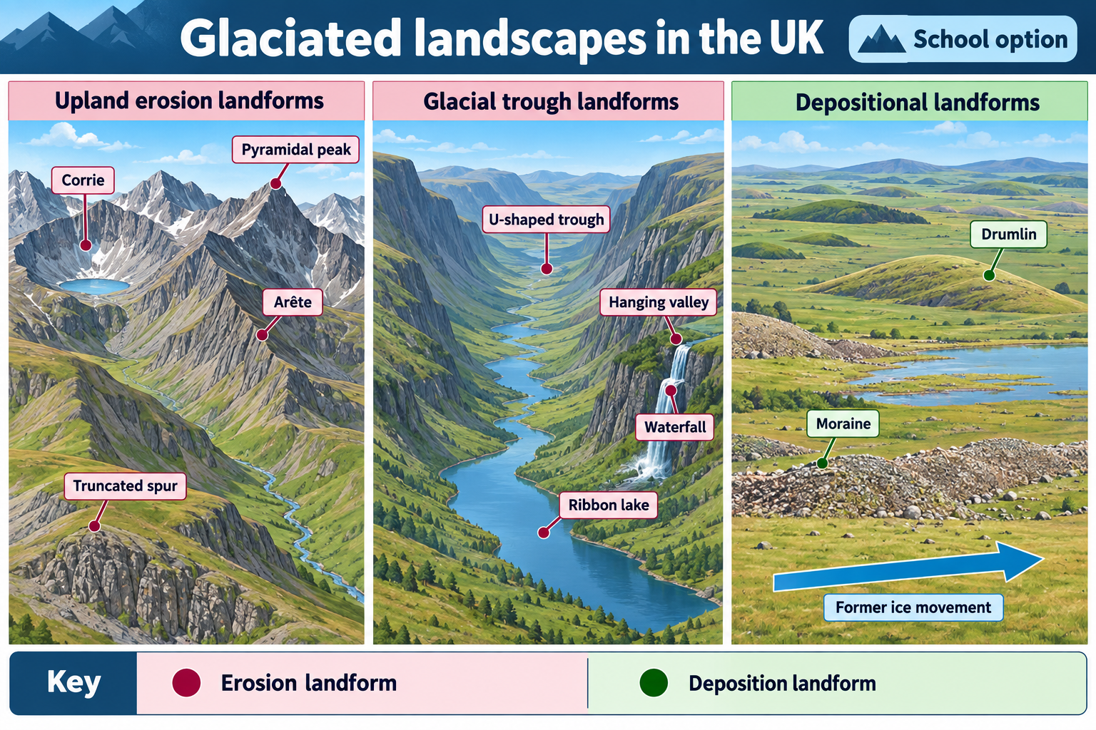
- Explain corries, arêtes, pyramidal peaks, truncated spurs, glacial troughs, ribbon lakes, hanging valleys, erratics, drumlins and moraines in a UK upland example.
- Evaluate tourism, farming, forestry and quarrying, their land-use conflicts, social/economic/environmental effects and management.
Key vocabulary
| Term | Meaning |
|---|---|
| freeze-thaw | water freezes/expands in cracks and can loosen rock |
| plucking | ice removes loosened rock |
| till | unsorted material deposited by ice |
| erratic | rock transported away from its source |
| moraine | accumulation of glacial debris |
How the geography works
Freeze-thaw can loosen rock before or beside ice. Moving ice rotates in hollows, abrades and plucks bedrock, and can bulldoze or transport debris. Erosion widens and deepens valleys. Retreating ice deposits unsorted till; meltwater sorts sediment into outwash. Erosional forms include corries, arêtes, pyramidal peaks, truncated spurs, troughs, hanging valleys and ribbon lakes; deposits include erratics, drumlins and moraines.
Key vocabulary for describing glaciated landscapes
| Term | Meaning and use |
|---|---|
| glacier | A persistent mass of ice that moves under gravity; it can be a valley glacier or part of a much larger ice sheet. |
| ice sheet | A very large body of glacial ice covering an extensive area of land. |
| accumulation | Gain of snow and ice, for example through snowfall and wind-blown snow. |
| ablation | Loss of glacier ice through melting, sublimation, calving or other processes. |
| equilibrium line | Approximate boundary separating a glacier’s accumulation area from its ablation area over a stated period. |
| firn | Old, compacted snow that has survived at least one melt season and is becoming glacial ice. |
| basal | At or near the glacier bed; basal ice and meltwater influence erosion and movement. |
| freeze-thaw weathering | Water enters a crack, freezes and expands, and repeated freezing and thawing can loosen rock. |
| abrasion | Rock fragments embedded in or carried by ice scrape and grind the bedrock. |
| plucking | Ice freezes onto loosened bedrock and removes blocks as it moves. |
| rotational slip | Movement of ice involving rotation within a hollow, helping deepen a corrie. |
| bulldozing | Ice pushes, deforms or shoves sediment and other material at its front or beneath it. |
| till | Poorly sorted sediment deposited directly by ice, commonly a mixture of sizes. |
| outwash | Sediment deposited by meltwater beyond or in front of ice; sorting and layering may be clearer than in till. |
| moraine | An accumulation or ridge of glacially transported debris, classified by its position or formation. |
| erratic | A rock fragment carried away from its geological source by ice and deposited elsewhere. |
| drumlin | An elongated, streamlined hill of glacial sediment, usually aligned with ice flow. |
| corrie / cirque / cwm | A steep-sided, armchair-shaped hollow formed near a glacier’s upper end. |
| arête | A narrow, steep-sided ridge between neighbouring corries or glacial valleys. |
| pyramidal peak / horn | A sharp summit shaped where several corries erode back towards one another. |
| truncated spur | A steep, blunt-ended ridge where a glacier cuts across an interlocking river spur. |
| glacial trough | A broad, deep valley with a characteristic U-shaped cross-section, modified by glacier erosion. |
| ribbon lake | A long, narrow lake occupying an overdeepened section of a glacial trough. |
| hanging valley | A tributary valley left higher than a main glacial trough after the larger glacier erodes more deeply. |
| overdeepening | A basin eroded below the level of its outlet, often allowing a lake to form after the ice melts. |
| paraglacial | Landscape change caused by adjustment to glaciation and deglaciation, including erosion of loose sediment after ice retreats. |
Use the vocabulary precisely. A glacier is moving ice; a glaciated landscape is the landform pattern left by ice and related processes. A lake can occupy a glacial hollow without having been made only by direct scouring: a rock threshold, moraine or later dam can also influence whether water is retained.
How far did ice cover Britain?
During the Quaternary, repeated cold stages allowed ice sheets and valley glaciers to expand across Britain. The last major glacial period is commonly called the Devensian in Britain. At its greatest extent, a British-Irish Ice Sheet covered large areas of Great Britain and Ireland, while ice from different accumulation areas flowed through uplands and lowlands towards surrounding seas. The broad maximum extent is a map pattern, not a single line whose exact position is identical in every reconstruction: evidence from landforms, sediments and dated deposits continues to refine the history.
In northern England, the Lake District was heavily glaciated. A local ice cap and valley glaciers shaped the central fells and sent ice down radial valleys, while ice movements and ice-sheet margins also affected surrounding lowlands. British Geological Survey regional accounts describe widespread glacial deposits and extensive erosion, including corries, arêtes and lake-filled glacial troughs in the central Lake District. AQA expects students to know the maximum extent of UK ice cover during the last Ice Age, but a GCSE answer should use the supplied map, legend and date range rather than claim that every upland was under ice at exactly the same time.
On an ice-extent map, first identify the key: ice limits, flow arrows, present-day coastlines, land above a certain elevation, or glacial deposits may be shown with different symbols. Check whether the map shows an ice sheet, local glaciers or the outermost limit reached during one or more advances. Ice-flow arrows may represent inferred movement from striations, erratics, drumlins or other evidence. An arrow shows direction, not necessarily a uniform speed or a single uninterrupted advance.
An ice sheet is thickest where snow accumulates and ice flows outward under gravity. Valley glaciers are channelled by relief, so their erosional effects concentrate along valleys. As ice expands, it can override lower ground and cross existing watersheds. As climate warms, ablation can exceed accumulation and glacier margins retreat. Retreat means that the glacier front shifts upslope or up-valley; the ice itself continues to flow while the margin retreats. Do not describe a glacier as reversing its flow direction just because its terminus withdraws.
When the ice melts, landscape change does not stop. Meltwater cuts channels and sorts sediment; slopes adjust; rivers transport loose glacial debris; lakes fill with sediment; vegetation and soils gradually develop. The landscape inherited from ice is therefore modified by later processes. This explains why an apparently glacial valley may also contain river terraces, landslides, peat, modern lakeshore deposits and human changes.
Glacial process sequence
Weathering before erosion
Freeze-thaw is a form of mechanical weathering. Water enters joints and cracks in exposed rock. When the water freezes it expands, exerting pressure on the sides of the crack. Repeated cycles can loosen fragments. The fragments may later be picked up by ice, moved by gravity, or carried by meltwater. Freeze-thaw does not require a glacier to be directly grinding the bed; it is most effective where water can enter cracks and temperatures repeatedly cross the freezing point. It should be distinguished from abrasion, which is the wearing of rock by debris moving with ice.
Abrasion and plucking
Ice can carry rock fragments at its base. As the glacier moves, this load scratches, grooves and polishes the bedrock. Larger clasts may make deep striations; finer debris can grind the surface. Abrasion depends on the debris supply, the pressure exerted by ice, basal conditions and the resistance and structure of the rock. A polished surface or striation can indicate ice movement, but a single groove should be interpreted with its direction, setting and other evidence.
Plucking occurs where ice interacts with fractured rock. Meltwater can enter a crack and refreeze, bonding part of the rock to the glacier. As the ice moves, blocks may be pulled away. Joints, bedding planes and changes in pressure can create suitable weaknesses. The newly exposed bed can then be abraded. In a simplified GCSE account, abrasion and plucking often operate together: abrasion grinds the bed and plucking removes blocks, producing an uneven, overdeepened surface.
Ice movement and sediment transport
Glaciers move downslope because gravity acts on ice under its own weight. Movement includes internal deformation as ice crystals shift, and basal sliding where meltwater or a deformable bed allows ice to move across its base. Flow rates vary with thickness, gradient, temperature, pressure and the bed. For GCSE explanation, the key idea is that flowing ice transports material and exerts force; it does not need to be described as a solid block simply sliding intact.
Sediment can be carried on the glacier surface, within the ice or at its base. Material may be inherited from weathered slopes, plucked from the bed or entrained at the glacier margin. When ice pushes loose material forward it can bulldoze a ridge or deform sediment. At the margin, debris may accumulate in a moraine. A moving glacier sorts sediment differently from a meltwater stream: till deposited directly by ice is generally poorly sorted, while flowing water can separate grains according to size, shape and energy.
Deposition by ice and meltwater
Ice deposits till when it melts or loses the ability to transport its load. Till may contain clay, silt, sand, pebbles and large boulders in a poorly sorted mixture. It can blanket a landscape or form ridges associated with an ice margin. A boulder may be an erratic if its lithology differs from the local bedrock and it can be traced to a distant source. The origin claim should be supported by geological comparison; a large rock is not automatically an erratic.
Meltwater deposits outwash. Flowing water carries sediment away from ice and deposits it as velocity falls. Coarse gravel is commonly left closer to energetic channels, while finer sand and silt can travel farther, though local flow and sediment supply change the pattern. Outwash can form sorted, layered deposits and channel features. A deposited landform may therefore include both glacial till and water-laid sediment; use texture and layering evidence to distinguish them.
A process-to-evidence table
| Process | What it does | Possible landscape or field evidence | A careful interpretation |
|---|---|---|---|
| Freeze-thaw | Loosens rock in cracks | Angular fragments, frost-shattered material | Weathering prepares debris; it does not prove that a glacier transported it. |
| Abrasion | Scrapes and grinds bedrock | Striations, polish, smoothed rock surfaces | Check orientation and geological context; water and other processes can also modify rock. |
| Plucking | Removes jointed blocks | Rough, broken bedrock surfaces and quarried faces | Jointing and ice movement help explain removal; do not infer flow direction from a single block. |
| Rotational slip | Ice rotates in an upland hollow | Overdeepened corrie basin and steep backwall | Combine the landform shape with process explanation; the basin may later contain a tarn. |
| Bulldozing | Pushes or deforms debris at an ice margin | Ridge or deformed sediments near a former margin | A ridge may be a moraine, but its composition and position matter. |
| Direct ice deposition | Releases unsorted debris as ice melts | Till containing a wide range of particle sizes | Poor sorting supports deposition by ice, but later reworking can alter it. |
| Meltwater deposition | Sorts and deposits sediment as flow loses energy | Layered or sorted sand and gravel | Look for bedding and grain-size patterns; outwash is deposited by water, not directly by ice. |
No one feature gives a complete history. Combine landform shape, sediment properties, bedrock, map position, flow orientation and dated evidence when available. A GCSE answer normally does not need advanced dating methods, but it should avoid treating a landscape as the product of one process at one moment.
Erosional landforms
Corries
A corrie (also called a cirque or cwm) begins as a hollow on a mountainside, commonly on a shaded aspect where snow can accumulate and persist. Wind-blown snow, avalanches and repeated snowfall increase the mass of snow. As it compacts into ice, a small glacier forms. Freeze-thaw weathering loosens material in the steep backwall. Ice moves in a rotational manner within the hollow; abrasion deepens the basin and plucking steepens the backwall. The basin becomes deeper than its lip, leaving a steep headwall and a rock threshold. After the ice melts, water may collect in the hollow to form a corrie lake or tarn.
The process is not a guaranteed sequence in every hollow. Aspect, elevation, snow supply, geology and duration of ice cover affect development. A tarn is strong evidence of a water-filled hollow but the water may be retained by a rock lip or sediment. A corrie can also be dry or partly infilled. In a labelled profile, show the steep backwall, overdeepened basin, lip and possible tarn. An aerial photograph should be read with contours so that the hollow’s shape is not confused with a river valley.
Arêtes and pyramidal peaks
An arête is a narrow, sharp-sided ridge. It can form when corries develop on opposite sides of a ridge or when neighbouring glaciers erode valleys on either side. Freeze-thaw and slope failure weaken the ridge while glacial erosion cuts back into it. Continued erosion narrows and sharpens the divide. A pyramidal peak forms where three or more corries erode back towards one another, leaving a pointed summit between them.
The terms describe related but distinct landforms. An arête is the ridge; a pyramidal peak is a summit. A mountain’s present sharp form can also be modified by rock structure, weathering, frost action and post-glacial slope processes. In the Lake District, the high central fells provide examples of rugged glacial summit topography, including corries and ridges around Helvellyn. Use a map to identify corries facing into different aspects and the ridge between them rather than naming an arête from a single distant photograph.
Truncated spurs
Before glaciation, a river valley often meanders around projecting interlocking spurs. A valley glacier is wider and more powerful than a river and may cut relatively directly through the ridge ends. Abrasion and plucking steepen and blunt the former spurs, producing truncated spurs that face the trough as steep, triangular or blunt valley sides. The glacier can also deepen and widen the valley floor.
In a plan view, show a former winding river route and a more direct ice-flow direction. In a cross-section or valley-side photograph, look for repeated blunt ends at similar positions along a trough. The former river pattern is a reconstruction, so do not claim that the map shows the pre-glacial valley unless it contains evidence to support this. Truncated spurs help explain why a glacial trough may have a straighter course than the river that occupies it today.
Glacial troughs and ribbon lakes
A glacial trough is a wide valley with a steep-sided, often U-shaped cross-profile. A river typically erodes a narrower V-shaped valley and leaves interlocking spurs. A glacier fills more of the valley, presses against the floor and sides, and erodes both laterally and vertically through abrasion and plucking. It may remove projecting spurs and overdeepen parts of the floor. When the ice melts, the broad valley remains, often with a flatter floor and steep valley sides.
Do not treat a U shape as proof on its own: bedrock, later erosion and valley setting should also be considered. A cross-profile should be drawn across the valley, not along it. Compare valley width to the modern river channel; the trough can be many times broader than the small river flowing through it. A broad floor may now contain farms, roads, settlements or a lake, which reflects post-glacial use as well as glacial form.
A ribbon lake is long and narrow, occupying an overdeepened part of a glacial trough. Ice may erode more deeply where it is thick or where the valley floor is structurally weaker. A bedrock step or moraine at the outlet can help retain water. Windermere is an example of a long lake in a glacial valley system, although the lake’s precise shape and basin history reflect both glacial erosion and deposited material. In a map view, identify its elongated orientation within the trough; in a cross-section, indicate the deeper basin and the surrounding U-shaped valley.
The term “ribbon lake” should not be applied to every long lake. Evidence for a glacial trough setting and an overdeepened basin makes the interpretation stronger. Reservoirs can also be long and narrow but are engineered water bodies; check map symbols, dam locations and place history before identifying a feature.
Hanging valleys
Smaller tributary glaciers join a larger trunk glacier. The main glacier is thicker, carries more ice and commonly erodes its valley more deeply. After the ice melts, the tributary valley floor is left higher than the floor of the main glacial trough. This is a hanging valley. A stream may descend from it as a waterfall or steep tributary, but a waterfall is an effect that may develop after deglaciation rather than a necessary part of the landform definition.
In a diagram, show a main trough, a smaller tributary valley meeting it above the main floor, the former direction of ice flow and the height difference. A waterfall can be sketched at the junction, with a label that the river has adjusted to the step. In the Lake District, tributary valleys around the major troughs provide a landscape in which this relationship can be investigated. Use contour maps to compare valley-floor elevations and aerial or ground photographs to see the junction.
How to distinguish valley shape from valley process
The common contrast “rivers make V-shaped valleys and glaciers make U-shaped valleys” is a useful first model, not a complete account. River valleys can be widened by weathering and mass movement; glaciers can inherit valley geometry from earlier rivers; rock structure guides both; and ice can be thin or confined. A profile records shape, while a process explanation explains how the shape developed. In an unfamiliar photograph, describe the cross-section first and then connect it cautiously to the likely agent of erosion.
Depositional landforms
Erratics
An erratic is a rock transported by ice from a source area and deposited on different bedrock. The source may be identified because the erratic’s rock type differs from the local geology. Its position can help reconstruct past ice movement when combined with other erratics, striations, sediment and landform patterns. A map of erratic locations can show a broad transport path, but isolated examples may have been moved again by people or later processes.
To explain an erratic, link its rock type to the source, transport in or on moving ice, and deposition when ice melts. A large boulder is not an erratic simply because it is large: it needs evidence that it is not locally derived. Glacial deposits can also be reworked by rivers, slopes and construction, so the original transport interpretation should be checked in context.
Moraines
Moraines are accumulations or ridges of debris associated with a glacier. Names describe their position or formation:
- Lateral moraine builds along the side of a glacier from material falling from valley sides or carried along the ice margin.
- Medial moraine forms where two lateral moraines join as neighbouring glaciers merge; the joined debris line travels near the middle of the ice.
- Terminal or end moraine is deposited at or near a glacier’s furthest margin, often as a ridge marking an advance or stillstand.
- Recessional moraine is a ridge deposited during a temporary pause or readvance as the glacier retreats in steps.
- Ground moraine is a spread of material deposited beneath ice as it melts or releases debris, rather than one ridge at the front.
These are simplified GCSE descriptions. Moraine form and composition vary with ice dynamics, topography, sediment supply and the way the glacier melts. A ridge may be modified by meltwater or later erosion. A labelled valley diagram should place lateral material along the valley sides, a medial line where glaciers join, and an end ridge across the valley near an ice margin. Always show the flow direction so that labels are meaningful.
Moraines can dam water and help form lakes, mark former glacier margins and provide evidence of change through time. They may also be used for agriculture, forestry, settlement or aggregate extraction. Their loose sediments can be vulnerable to erosion or landslides, and their economic use can create conservation conflicts. A landform can be both evidence of past glaciation and part of a contemporary managed landscape.
Drumlins
A drumlin is an elongated hill, often composed of till, aligned broadly parallel to former ice flow. A drumlin field can contain many streamlined hills with a tapered end and a steeper or blunter end, although forms vary and are not always perfectly symmetrical. Ice flowing over or around sediment can mould the land surface; theories of how particular drumlins formed include deformation and deposition beneath moving ice, and the detailed origin remains more complex than a single classroom sketch suggests.
At GCSE, describe the elongate shape, sediment, orientation and relationship to former ice movement. A drumlin map should show several aligned hills, not just a single oval contour. The taper can suggest ice-flow direction in a textbook model, but students should follow the map key or source’s convention because interpretations of stoss and lee ends vary. A drumlin made mainly of till is a depositional landform, but its streamlined shape reflects the interaction of sediment and moving ice.
Till and outwash in a landscape
Till can form a widespread mantle over lower ground or be concentrated into ridges and hills. Its unsorted mix of particles contrasts with the sorting that occurs in meltwater. Outwash may form beyond an ice margin where meltwater channels spread across a plain and lose energy. Streams can braid around temporary sediment bars, leaving layered sands and gravels. Later rivers can rework those deposits, while soil and vegetation hide the original surfaces.
To identify a deposit, record particle-size range, sorting, layering, shape, composition and landscape position. A mixed matrix with large clasts may support till deposition, while sorted and stratified layers support water-laid sediment. Neither observation on its own is definitive: glacial sediments can be reworked, and multiple depositional phases can sit together. The AQA answer should explain why ice deposits till and why meltwater sorts outwash, then use the given evidence to support an interpretation.
Compare erosional and depositional evidence
| Question to ask | Erosional landform evidence | Depositional landform evidence |
|---|---|---|
| What shape should I look for? | Hollow, trough, ridge, steep face or overdeepened basin | Mound, ridge, blanket, boulder or layered plain |
| What material is exposed? | Smoothed or striated bedrock, plucked blocks | Till, moraine, erratic, drumlin sediment or outwash |
| What direction matters? | Ice-flow direction and valley alignment | Sediment alignment and former ice-margin position |
| Which processes explain it? | Abrasion, plucking, rotational slip, freeze-thaw | Transport, bulldozing, melting, till deposition or meltwater sorting |
| What can change the interpretation? | Rock structure, later rivers, slope processes | Reworking by rivers, people, vegetation and weathering |
A good answer does not call every feature “glacial erosion.” It identifies whether ice removed material, transported it, pushed it, or released it during melting. This distinction helps explain how one valley may contain an erosional trough, a moraine at its mouth and a ribbon lake in an overdeepened section.
Place example
The Lake District is a possible UK upland example. Tourism supports jobs but can cause congestion, footpath erosion and pressure on habitats. Farming, forestry and quarrying add land-use demands; path maintenance, visitor management and zoning can reduce impacts but require resources.
The Lake District: a connected glacial landscape
The Lake District in north-west England is a strong UK upland example because it combines high central fells, glacial valleys, lakes and extensive evidence of glacial erosion and deposition. Its scenery also supports tourism, farming, forestry and conservation. The British Geological Survey describes extensive glacial erosion in the central Lake District, including corries, arêtes and lake-filled troughs, alongside widespread glacial deposits across the wider region. The landscape is not the product of ice alone: bedrock geology, relief before the ice, later rivers, slope processes, vegetation and human use have all influenced what can be observed today.
A useful regional map begins with the central high ground around Scafell Pike, Helvellyn and the valleys radiating towards lakes and lower country. Label Windermere, Ullswater, Derwentwater, Thirlmere, Borrowdale, Langdale and the main road corridors. Use contours to identify ridges, steep valley sides and lake basins; add a north arrow and scale. Mark the likely former flow direction only where topography or evidence supports it. The map should help locate examples, not imply that every named lake or valley formed by exactly the same process.
Windermere is a long lake in a glacially modified valley. It can be used to illustrate a ribbon-like lake occupying a deep trough, but its basin reflects both erosion and depositional controls. The Lake District’s bedrock is geologically varied; valley orientation and structure influence where ice could flow and which rock units were eroded. The BGS regional geology account describes central Lake District troughs and rock basins as products of substantial glacial erosion, with deposits also changing the relief. At GCSE, this is a reminder to combine the glacial process model with geological evidence rather than claim that ice carved uniformly through identical rock.
The central fells around Helvellyn provide a landscape for corries, ridges and high relief. Corries around the massif illustrate how snow accumulation and rotational erosion can create hollows. Where corries erode back into a ridge, a sharp arête may remain; where several corries approach one summit, a pyramidal peak can develop. The ridge routes and corrie basins can be located using a topographic map and compared with aerial imagery. Do not infer that a specific hollow was occupied by a glacier merely from a shadow in a photograph; check its shape, elevation, aspect and geological mapping.
The valleys radiating from the central fells show how a large valley glacier can broaden a former river valley, steepen its sides and overdeepen parts of its floor. Tributary valleys can be left above the main trough. Once ice melts, streams and waterfalls adjust to the difference in valley-floor level. The modern valley also contains farms, roads, woodland, settlements, paths and water-management infrastructure. Those present-day uses should be kept distinct from the inherited glacial landform, while still recognising that physical geography shapes accessibility and economic activity.
Glacial deposits are also part of the regional story. Till can mantle low ground, while moraines record local ice margins or pauses in retreat; meltwater sorted deposits occur in appropriate valley settings. The BGS describes the Lake District as having a complex sequence of glaciation and deglaciation, including extensive deposits and local later-stage corrie glaciation. This chronology is more complicated than a single glacier advancing once and then melting. At GCSE, students can use a simplified last-Ice-Age framework while avoiding claims that every deposit formed at the same moment.
| Lake District feature or area | Useful geographical connection | Evidence to collect or verify |
|---|---|---|
| Central fells around Helvellyn | Corries, arêtes, pyramidal summit forms and steep relief | Contours, aerial view, field sketch and BGS geology |
| Windermere valley | Long lake in a glacially modified trough; water and visitor use | Lake and valley map, cross-profile, water-management information |
| Borrowdale and surrounding troughs | Valley glacier erosion, tributary junctions and high-relief landscape | Valley shape, tributary heights, photographs and geological context |
| Lower valley deposits | Till, moraines, erratics or meltwater deposits where mapped | BGS superficial geology, sediment texture and landform position |
| High fell paths | Tourism, soil erosion, conservation and access management | Path condition, repair records and visitor-management information |
This matrix is a revision route rather than an assertion that all examples are visible from one place. Teachers may use another UK upland area; the AQA specification asks for an example, so follow the selected case study and map. If using the Lake District, state which valley, lake or fell provides the evidence for each landform.
Case-study method: describe, explain, locate
For each named landform, prepare a three-part evidence card:
- Describe the visible shape or mapped pattern—for example, a long lake in a broad valley or a steep hollow beneath a ridge.
- Explain the process sequence that could form it—such as abrasion and plucking overdeepening a trough, or corries eroding back to leave a ridge.
- Locate and support the interpretation with a named place, map, photograph, geological account or sediment evidence.
This prevents a place-name list from replacing geography. An answer that names Windermere, Helvellyn and Borrowdale but never describes a process is not a landform explanation. Likewise, a generic explanation may be incomplete if the question asks for a UK example. Place evidence can be a correctly located feature and a well-supported physical description; exact coordinates are useful in fieldwork but should not be invented.
Compare a map with an aerial image to identify elongated lake basins, ridges, valley junctions and possible corries. Then use a cross-section or field photograph to test the interpretation. A topographic map is especially useful for landform shape; a geological map reveals bedrock and superficial deposits; a photograph shows surface form but may conceal the wider valley relationship. Using more than one source reduces the chance of labelling a river-cut feature as glacial simply because it lies in an upland.
Economic activities and land-use conflicts
The AQA specification requires an overview of tourism, farming, forestry and quarrying in glaciated uplands, then a tourism example that covers attractions, social, economic and environmental impacts, and management. These activities can coexist, but they compete for land, access, water, scenery and ecosystem services. The importance of each activity varies from valley to valley and through the seasons.
Tourism
Tourists visit glaciated uplands for mountain scenery, lakes, walking, climbing, cycling, watersports, wildlife, heritage and village facilities. Steep fells, corries, arêtes, waterfalls, lakes and changing weather provide both visual attractions and outdoor recreation. The Lake District National Park is also a cultural landscape shaped by farming, industry, settlement and conservation, not an empty wilderness. Visitors spend money in accommodation, cafés, outdoor equipment shops, transport, attractions and local services.
Tourism can support employment and business income, maintain local services and encourage investment in paths, visitor information and public transport. Seasonal demand provides opportunities for small businesses but can create insecure or seasonal work. High visitor demand may increase housing costs or lead to holiday accommodation pressure; local outcomes vary, so use current local evidence rather than assume every village has identical housing effects. Congestion can make travel slower and create parking pressure, noise and emissions, particularly on narrow roads and at popular honeypots.
Environmental impacts include footpath erosion, trampling of vegetation, disturbance to wildlife, litter, traffic emissions and pressure on water quality. In uplands, thin soils and wet conditions mean that repeated footfall and rainfall can create a path channel. Water then runs down the eroded path, carrying soil into streams and lakes. Walkers may spread out to avoid mud or damage, making a wider scar. The effects can extend beyond the path: sediment can reach rivers and lakes, and damage to protected habitats can require restoration.
Farming
Hill farming, including sheep and cattle grazing, has shaped the Lake District’s open fell and valley landscapes. Farming produces food and supports rural livelihoods, local knowledge, cultural heritage and landscape management. Farmers maintain walls, hedges, tracks and fields; grazing influences vegetation structure. Farm businesses may diversify into accommodation, local food, guiding or conservation agreements.
Farming faces challenges including steep terrain, difficult access, weather exposure, low productivity on some land and fluctuating prices. Grazing levels can affect habitats: overgrazing may prevent tree regeneration and damage vegetation, while reduced grazing can change open landscapes and species distributions. These are not one-size-fits-all outcomes; stocking, soil, elevation, season and management objectives matter. Farmers may also face tension between food production, public access, water quality, nature recovery and tourism expectations.
Forestry
Forestry supplies timber, supports employment and can provide recreation, habitat and carbon storage. Woodland can be native, mixed or commercial plantation, and management choices shape biodiversity and landscape character. In a glaciated upland, forests may occupy steep slopes or valley land, affecting views, access, habitat connectivity and water movement. Planting and felling can cause conflict when visitors, farmers, conservation organisations and timber businesses value land differently.
Forest management can reduce conflict through careful choice of species, scale, location, access routes and timing of operations. Native woodland restoration may benefit some habitats and reduce slope erosion, while commercial timber production has different objectives and may create road or landscape impacts. No forest automatically prevents flooding or erosion; effects depend on soil, species, age, location and management. Distinguish an intended benefit from a measured outcome.
Quarrying
Quarries extract rock and mineral materials used in buildings, roads, aggregates and other industries. Quarrying can provide skilled and local employment, supply construction materials and support transport or processing businesses. The Lake District’s rock resources and industrial history form part of its cultural landscape. A quarry is also an example of how geology has direct economic value.
Potential costs include visual change, noise, dust, heavy lorry traffic, habitat loss, effects on water and conflict with tourism or conservation aims. Restoration after extraction can create wildlife areas, lakes or recreational space, but it cannot always recreate the original landform, rock face or habitat. Planning conditions, operating hours, haul routes, dust controls, water monitoring and restoration plans can reduce some impacts. The decision balances local jobs and material supply against landscape and environmental costs.
Land-use conflict matrix
| Activity | Benefits | Possible conflict | Possible response |
|---|---|---|---|
| Tourism | Income, jobs, services and visitor access to scenery | Congestion, path erosion, seasonal pressure and habitat disturbance | Public transport, visitor information, path repair, parking strategy and seasonal management |
| Farming | Food, livelihoods, landscape heritage and land stewardship | Grazing pressure, access disputes, water quality or competing conservation goals | Agri-environment support, agreed access, catchment management and targeted grazing |
| Forestry | Timber, work, recreation, habitat and carbon storage | Visual impact, access, species choice and effects on land or water | Landscape-sensitive design, mixed/native woodland, access planning and phased harvesting |
| Quarrying | Jobs and building materials | Noise, traffic, dust, landform and habitat change | Planning controls, monitoring, restoration and locally appropriate haulage |
Conflict is not always a direct “environment versus people” choice. A farmer may support habitat protection and tourism while needing viable income; a visitor may value paths but prefer not to see repair work; a quarry can provide materials needed for conservation path repairs while altering landscape elsewhere. Identify the stakeholders and scales involved, then explain who gains, who bears costs and how decisions are made.
Tourism case study: the Lake District
Attractions and visitor patterns
The Lake District attracts visitors because of its glaciated scenery: deep lakes, broad valleys, steep fells, corries and high ridges. Outdoor recreation includes walking, climbing, cycling, boating and watersports. Villages, cultural heritage, farms, gardens, museums and historic transport routes add attractions beyond the landforms. The Lake District National Park Authority’s visitor information describes the area as drawing people for scenery, wildlife, history and culture. Current visitor totals vary by survey year and method; if a question supplies an annual figure, state its year and source rather than treating it as a permanent count.
The National Park Authority’s recent reporting refers to about 19 million annual visitors, illustrating the scale of pressure across the area. This should be presented as the authority’s reported estimate for its cited period, not as an exact count at every attraction or a daily capacity. Visitors concentrate unevenly: a summit route or lakeshore honeypot may experience severe pressure while a less accessible valley remains quieter. A park-wide average can conceal this spatial difference.
Social and economic effects
Visitor spending supports accommodation providers, shops, cafés, outdoor guides, transport, attractions and local suppliers. The resulting jobs may help sustain village services and provide income for farms and community businesses. Footpaths, visitor centres, toilets and public transport can serve residents as well as visitors. Tourism may also increase appreciation of glacial landforms and strengthen support for conservation.
However, seasonal demand can create insecure or short-term employment, and increased demand for second homes or holiday lets may make housing less affordable for some local workers. Congestion and parking competition can affect residents’ journeys and emergency access. Popular paths can be crowded, and visitor behaviour may disturb livestock, wildlife or other users. These effects are not identical in every settlement; use local surveys, housing data or traffic observations when making a place-specific claim.
Environmental effects and the path-erosion feedback
Repeated footfall compresses or removes vegetation and exposes thin upland soils. Heavy Cumbrian rainfall can then wash material downslope, producing gullies and sending sediment towards watercourses. As a muddy path becomes difficult to walk on, visitors may walk around the damaged section and widen the scar. This feedback links human use, weather and landscape processes: visitor numbers increase the pressure, but rainfall and slope affect how quickly damage develops.
The Lake District National Park Authority notes that path erosion can damage vegetation, species and habitats, and sediment can enter rivers and lakes below. Some affected places are Sites of Special Scientific Interest or Special Areas of Conservation. Path erosion can therefore create a tension between access to the landscape and protection of the landscape that attracts visitors. Closing routes may protect a site but displace walkers to other paths or reduce access; a repaired route can protect habitat while making a popular attraction easier to reach.
Traffic to honeypots creates additional pressure: congestion, vehicle emissions, parking overflow and conflict on narrow roads. Boating and lakeshore use can create local effects on water, wildlife and access, though pressures depend on activity and management. Tourism may contribute to water-quality pressure through accommodation or visitor facilities, but that impact should be tied to evidence about a location rather than assumed from visitor numbers alone.
Management: Fix the Fells and sustainable travel
Fix the Fells is a partnership that repairs eroded upland paths and protects sensitive habitats while maintaining access. The programme includes the Lake District National Park Authority, National Trust rangers and volunteers, with other partners contributing. Repair methods can include stone pitching, drainage channels, steps, path-edge definition, revegetation and work to keep water from running down the path. Techniques vary by slope, geology, drainage and habitat; a design for one route should not be copied blindly to another.
The Lake District National Park Authority explains that repairing eroded routes can reduce vegetation and habitat loss and reduce sediment washing into rivers and lakes. A damaged path at Coledale was described as four metres deep, ten metres wide and over 300 metres long before repair—an illustration of how a narrow line of footfall can develop into a large scar. This is a documented example of path damage, not a measurement of every trail in the National Park.
In 2026, a three-year repair project began on Swirls Path on Helvellyn. The National Park Authority reported that the first year was expected to cost £220,000; about 100 tonnes of stone had been flown to the route by helicopter, and the path is being widened and rebuilt with stone pitching. The project aims to keep walkers on a more resilient route and reduce damage to surrounding vegetation and thin soils. Helicopter deliveries avoid the need for heavy vehicles on a mountain route but have financial and environmental costs; path design and visitor use determine whether repaired sections remain effective.
The trade-off is visible: path construction can temporarily disturb a site, require substantial labour and materials, and change the look or walking experience of a route. Yet leaving an eroding path unrepaired may lead to a wider scar, habitat damage and sediment loss. Monitoring can compare path width, depth, drainage, adjacent vegetation and visitor movement before and after repairs. Repair quality also depends on maintenance: blocked drains or fresh storm damage may require new work.
Sustainable travel measures seek to reduce car congestion and improve access. The National Park Authority’s sustainable tourism information describes public-transport improvement, traffic management and visitor information as ways to influence travel behaviour. In 2026, its Swirls Path project also reported a link to Thirlmere catchment management, including potential benefits from slower runoff and reduced sediment erosion. A visitor bus can reduce some car journeys only if routes, frequency, fares, accessibility and connections match how people travel; an advertised service alone does not prove that traffic fell.
Other approaches include clear route information, parking management, agreed seasonal restrictions in sensitive areas, visitor codes, ranger presence, trail maintenance and investment in public toilets or waste facilities. Management may direct use away from fragile land, but this can concentrate pressure elsewhere. A closure needs reasons, duration, alternative routes and communication. An effective evaluation asks whether the approach reduces the impact, who can still access the landscape, who pays, and whether monitoring shows an improvement.
Evaluate the tourism balance
The Lake District’s tourism is not sustainable merely because the area is protected as a National Park or World Heritage property. Sustainability depends on whether visitors, residents, businesses and conservation bodies can maintain the landscape and community over time. Benefits include livelihoods, local services, outdoor recreation and public support for conservation. Costs include congestion, housing pressure, path damage, habitat disturbance and carbon emissions from travel. The distribution is uneven: businesses may gain income, residents may face traffic or housing effects, and conservation organisations may carry repair costs.
Fix the Fells directly addresses one physical impact—erosion on heavily used paths—and can protect access as well as habitat. It cannot by itself manage all visitor pressures, change travel modes or ensure affordable housing. Public transport and visitor information can tackle some car-related impacts, but they need reliable service and visitor uptake. A balanced conclusion therefore supports a combination: repair routes where damage threatens habitat and safety; maintain and monitor paths; make lower-impact travel practical; guide use in sensitive areas; and include residents, farmers and businesses in decisions.
For a high-mark evaluation, identify the criteria first. If the aim is habitat protection, sediment reduction and vegetation recovery are key measures. If the aim is social equity, access for residents, disabled visitors and local workers matters. If the aim is economic resilience, reliable year-round income and local supply chains matter. One strategy can perform well against one criterion and poorly against another. State a judgement based on the specified priority and acknowledge the evidence that would be needed to confirm long-term success.
Maps, data and evidence
Use contour maps, aerial images and field sketches to identify landforms. A corrie often has a steep back wall and overdeepened basin; map evidence should support the label. Avoid identifying a feature from one photograph alone.
Read glaciated landscapes from maps and photographs
On an Ordnance Survey-style topographic map, close contour lines indicate steep slopes; widely spaced contours indicate gentler ground. A corrie can appear as a bowl-shaped hollow high on a mountain, with contours enclosing a basin and a steep backwall. A sharp ridge between hollows may indicate an arête. Several corries around a peak can support the interpretation of a pyramidal summit. A broad valley with steep sides and a relatively flat floor may be a trough; trace its tributaries and compare their floor levels to look for hanging valleys.
For lakes, follow the shoreline and contour pattern. A long narrow lake aligned with a valley may occupy a trough or overdeepened basin. Check whether a natural dam, moraine, rock threshold or modern reservoir structure could affect its origin and water level. A lake outline alone does not reveal whether it is a ribbon lake. Use geological maps or a regional landscape source to support the explanation.
Photographs provide detail but have limitations. Perspective can make a broad valley appear narrow, and a steep viewpoint can hide the floor. A single image may not show whether the feature joins a tributary valley or is part of a ridge system. State what is visible first—for example, a steep-sided hollow with a small lake—then explain why it is consistent with a corrie. Do not write that a photograph “proves” a glacier occupied the location unless the image contains evidence that can support that conclusion.
On a geological map, distinguish solid bedrock from superficial deposits. A bedrock unit can help explain resistance and valley direction; superficial mapping can identify till, alluvium, peat, sand and gravel or other deposits. Map patterns are interpreted at a stated scale and may not capture every small deposit. A cross-section can combine topography and geology to show a trough, lake basin and material beneath the surface.
Field enquiry: visitor pressure and path erosion
A field investigation can test whether path erosion varies with visitor use or slope. A suitable question is: “How does path width and depth vary between a heavily used section of trail and a less-used comparison section?” Another is: “Is the number of walkers associated with visible path damage at selected points along a route?” These questions specify measurable evidence while leaving room to consider rainfall, soil and maintenance as alternative explanations.
Before collecting data, select safe sites with permission and a clear sampling rule. A systematic sample might measure the path at fixed intervals, such as every 20 metres, from a known start point. Record path width, maximum depth below adjacent ground, drainage condition, vegetation cover beside the path, slope angle and visible sediment movement. Count walkers for a fixed duration at each site and record the time, day and weather. Count directions consistently and avoid recording identifiable personal details.
Use a tape measure across the path and a ruler or profile frame for depth. At each interval, take the same number of readings and define where the measurement is taken; otherwise the result will vary because one student chooses the deepest rut and another chooses an undamaged edge. A clinometer can measure slope, but the observer should remain on stable ground. Photographs should be taken from a consistent viewpoint with a scale object and should avoid identifiable people unless consent is obtained.
Display results with a scatter graph if both variables are continuous, such as visitor counts and path depth. Use a bar chart to compare mean path width between defined route sections. Map sampling points with grid references or GPS coordinates, while following school policy. Describe whether there is a relationship and identify outliers; correlation does not prove walkers alone caused erosion. A wet, steep section may be more eroded even with fewer visitors, and repaired paths may show little damage despite high use.
Improve reliability by repeating measurements or visiting on more than one day, but recognise that weather and visitor numbers vary. Record rainfall before and during the visit if available. Compare a popular path with a similar less-used path, but note differences in geology, slope, drainage and maintenance. A fair investigation cannot change all these factors, so its conclusion should be limited to the sites and sampling period.
The fieldwork must be safe. Check the route, weather, daylight, group size, mobile coverage and escape points; wear suitable footwear and clothing; follow teacher instructions; avoid approaching cliff edges or unstable slopes; and do not enter fast water. Mountain conditions can change quickly. Do not block a public path or disturb livestock, vegetation, rock or protected habitat. If the weather or ground becomes unsafe, stop or change the method.
Field enquiry: mapping a glacial landform
A second investigation may examine whether topographic evidence matches a predicted glacial landform. Students could map a corrie’s backwall, basin, lip and outlet using a field sketch, compass bearings, contours and photographs from safe viewpoints. A valley cross-profile can be sketched at measured points to compare valley-floor width with valley-side gradient. These observations describe present form; the past glacier and its processes are reconstructed from landform and geological evidence rather than watched directly.
At a deposited feature, students could compare sediment size and sorting across a transect. Use a consistent number of clasts and a defined method, such as measuring the longest axis of every fifth clast along a line. Record whether material is embedded in a matrix, whether layers are visible, and whether the sample is from a stream bar, moraine or disturbed path. Avoid taking rock or sediment from protected places without permission. A sediment sample that is well sorted may have been reworked by meltwater or later rivers; it should not be labelled “outwash” from size alone.
A field sketch should include a title, date, viewpoint, direction, key labels and the feature relationships. A photograph can complement a sketch but does not replace annotation. Add only features that can be seen or independently located; use dashed lines when inferring a former ice boundary. If exact elevation or distance is not measured, do not invent one. Good field geography uses a clear chain from question to sampling method, evidence, interpretation, limitation and conclusion.
Interpreting a landform data set
Suppose a map shows a high, bowl-shaped hollow, a small lake, a steep backwall and a sharp ridge connecting to a neighbouring hollow. A reasonable interpretation is that the hollow is a corrie and the ridge may be an arête. The explanation links snowfall accumulation, rotational erosion, plucking and abrasion, followed by corrie erosion on adjacent slopes. If another corrie cuts back from the opposite side, the ridge may become sharper. The map supports a landform interpretation; an ice-age date would need separate evidence.
Suppose a valley cross-profile shows a wide, relatively flat floor and steep valley sides, while a small river occupies only a narrow part of the valley bottom. This is consistent with a glacial trough. Explain that ice occupied a wider section than the modern channel and eroded the sides and floor through abrasion and plucking. Then note that geology and post-glacial processes can modify the cross-section. Use scale and axis units: vertical exaggeration can make a valley look steeper than it is.
Suppose sediment samples from a ridge are very poorly sorted and contain large angular clasts in a finer matrix. That evidence is consistent with direct deposition by ice and could support a moraine or till interpretation. If samples farther away are sorted and layered sands and gravels, meltwater outwash may be considered. A river can later rework glacial deposits, so map position, layering, clast type and nearby landforms strengthen or challenge the interpretation.
Construct a useful glacial diagram
Use a plan view for arêtes, corries, pyramidal peaks and drumlin alignment. Use a side profile for hanging valleys, valley glaciers and waterfalls at tributary junctions. Use a cross-section for U-shaped troughs, corrie basins and the relative depth of ribbon lakes. Use a sequence for process over time: a pre-glacial river valley; an advancing and eroding glacier; then the post-glacial trough and tributary step.
Label arrows carefully: ice flow, meltwater flow, sediment transport and slope movement are not the same. Add a small key for erosion and deposition. Use a before-and-after comparison when the question asks how ice altered an inherited landscape. Caption causal links rather than writing labels alone: “the larger trunk glacier erodes more deeply than the tributary glacier, leaving the tributary valley floor higher after melting.”
Common misconception
Not every lake is ribbon-shaped or glacial. Tourism is not automatically sustainable; visitor numbers, transport and management matter.
Self-check
- What is the difference between an ice sheet and a valley glacier?
- How does freeze-thaw weathering prepare rock for later transport?
- Explain the difference between abrasion and plucking.
- What is the difference between till and outwash?
- How can a corrie develop, and what is a tarn?
- How do two corries help form an arête?
- What process sequence can produce a pyramidal peak?
- How is a glacial trough different from a typical river valley cross-profile?
- Why may a tributary valley hang above a main trough?
- What is an erratic, and what evidence would support the label?
- Distinguish a lateral moraine from a terminal moraine.
- What shape and alignment are associated with drumlins?
- Name two attractions that bring tourists to the Lake District.
- Describe one physical impact of footpath erosion beyond the path surface.
- How does Fix the Fells manage path damage, and what trade-off can repairs create?
- Name one way that tourism can benefit local communities and one way it may create pressure.
- Why is a fieldwork correlation between visitor numbers and path depth not proof of cause?
Check your explanations
- An ice sheet covers a very extensive area; a valley glacier is channelled by relief through a valley.
- Water enters a crack, freezes and expands; repeated freeze-thaw can loosen angular fragments that ice or meltwater may later move.
- Abrasion is debris grinding or scratching bedrock; plucking is ice removing blocks from the bed.
- Till is deposited directly by melting ice and is usually poorly sorted; outwash is deposited by meltwater, which can sort sediment.
- Snow accumulates in a hollow and compacts into ice; rotational movement, abrasion and plucking deepen the basin. A tarn is a lake in a corrie.
- Glaciers in neighbouring corries erode back towards the ridge from opposite sides, narrowing it into a steep-sided ridge.
- Three or more corries erode back towards one summit, leaving a pointed peak.
- A trough is generally wider, with steep sides and a broader floor; a river valley is commonly narrower and V-shaped, although geology and later processes affect both.
- The larger trunk glacier usually erodes more deeply than the smaller tributary glacier; after melting, their valley floors are left at different heights.
- It is a rock transported from its source by ice. Its rock type should differ from local bedrock and ideally be traceable to a source region.
- Lateral moraine lies along a glacier’s sides; a terminal moraine is deposited near its furthest margin.
- Drumlins are elongated, streamlined sediment hills aligned broadly with former ice flow.
- Possible answers include scenery, lakes, mountain walking, climbing, cycling, wildlife, heritage and village attractions.
- Soil and sediment can be washed into streams and lakes; vegetation, habitat and water quality may be affected.
- It repairs and maintains paths using locally suitable techniques such as stone pitching and drainage. Work costs money and materials and can temporarily disturb or alter a site. 16–17. Answers should be place-specific. Economic benefits and environmental/social pressures can occur together; rainfall, slope, soil and maintenance may also influence path erosion.
Exam practice
Short-answer questions
Describe two features of a corrie shown on a photograph or map. State the evidence for each feature; do not begin by giving a long process explanation if the command is only “describe.”
Explain how glacial erosion can create a U-shaped valley. Include the inherited valley, abrasion, plucking, lateral erosion and the form left after the ice melts.
Compare till and outwash. Refer to their agent of deposition, sorting and likely landscape position. Include the possibility that either deposit may be modified later.
Explain how a hanging valley develops. Use a labelled diagram showing the trunk and tributary glaciers and the different depths of erosion.
Identify evidence that a boulder is an erratic. Explain why its size alone is not enough.
Extended response: physical landscape
Question: “Explain how glacial processes have produced distinctive landforms in a UK upland area.”
A strong answer chooses two or three features that allow different processes to be explained. For example, a corrie shows rotational erosion, plucking and abrasion; a trough and hanging valley show differential erosion by trunk and tributary glaciers; a moraine or drumlin demonstrates transport and deposition. Locate features in the Lake District if that is the chosen example, then connect each process chain to map, profile or sediment evidence. Avoid listing every landform in the specification without explaining any of them.
A model paragraph structure is:
- Identify the feature and where it occurs in the chosen area.
- Describe its shape and the evidence in the map, photograph or field sketch.
- Explain the process in chronological order.
- Add one qualification—for example, geology or post-glacial processes also influence the present form.
Extended response: tourism and management
Question: “Evaluate how tourism can be managed in a glaciated upland area.”
Use a judgement that matches a stated priority. For the Lake District, path repair such as Fix the Fells addresses erosion while preserving access. Visitor information, public transport and parking management address some travel pressures. Compare the scale, cost, environmental effects, access implications and who pays. Include both social and economic benefits and environmental pressures; then explain why one project alone cannot make tourism sustainable.
A sample evaluative paragraph:
“Fix the Fells can reduce the impact of concentrated walking by repairing and draining paths, keeping users on a durable route and limiting soil loss into nearby watercourses. The 2026 Swirls Path project shows that this can require substantial resources: the first year was estimated at £220,000 and materials had to be carried to a high mountain route. That cost may be justified where erosion threatens habitats and access, but repair does not address traffic to the trailhead or housing pressure in nearby settlements. It should therefore be combined with travel and visitor-management measures, with monitoring to see whether path width, vegetation and sediment loss improve.”
This paragraph uses reported project details and makes a conditional judgement. In an exam, use the supplied evidence, avoid treating the current project as a completed outcome, and do not generalise one path’s cost to all Lake District routes.
Improve an answer with command words
- Describe: state visible pattern, shape, location or data; use quantities and direction where shown.
- Explain: show how and why a process leads to a landform or impact.
- Compare: make paired statements about both places or features, not two disconnected descriptions.
- Assess/evaluate: compare benefits, costs and stakeholders, then make a supported judgement.
A clear paragraph often has a claim, evidence, process explanation and link to the question. Specialist vocabulary helps when it is accurate; a term used without an explanation does not replace reasoning. If a question supplies an unfamiliar glaciated landscape, apply the process model to its evidence instead of forcing a memorised Lake District example onto a different location.
Reconstructing former ice movement
Glaciers have melted, so geographers reconstruct their former extent and flow from evidence preserved in the landscape. A single clue is rarely enough. Striations are scratches or grooves on bedrock that may show the direction of ice movement. Their orientation should be checked against several nearby marks, the bedrock surface and other evidence; scratches can be difficult to interpret where later weathering has altered the rock. Erratics can indicate transport away from their source when their rock type is distinctive. A group of erratics can help trace a broad route, but the source geology must be known.
Drumlins and streamlined sediment forms are often aligned with past ice flow. A field of similarly oriented hills is more persuasive than one isolated mound, and the flow direction inferred from their shape should be taken from the map source or local interpretation. Moraines can mark an ice margin or a pause during retreat. A series of ridges may show that the ice front did not withdraw continuously. However, meltwater and later rivers can reshape or remove deposits, so an incomplete sequence should not be forced into a neat chronology.
Geological mapping combines these features with the composition and distribution of till and outwash. A clast within till may be traceable to a source area; the mixture can reveal material gathered along the route. The orientation of striations, distribution of erratics, alignment of drumlins and positions of moraines can then be compared with topography to infer movement. Each method has uncertainty: rock types can have more than one source, landforms can be modified, and deposits may relate to different advances or retreat stages.
The last Ice Age was not one static event. Climate varied, ice margins advanced and retreated, and local mountain glaciers sometimes formed within or after broader ice-sheet phases. Regional BGS accounts describe complex glacial sequences in northern England and distinguish deposits from different cold stages. For a GCSE answer, a simplified map of maximum extent is appropriate if it is what the question supplies, but avoid saying the entire UK was covered by a uniform ice sheet or that all mapped landforms formed simultaneously. Use “at its maximum extent” for the greatest mapped reach, then explain that ice thickness and flow varied across the region.
The term maximum extent refers to the furthest limit reached during the mapped glaciation, not to the place where ice was thickest, the location of every glacier front at one instant, or the continuous boundary of modern ice. A map may combine evidence from different locations and times to show an outer limit. Read its caption and dates before interpreting it. If a question asks where ice reached, name the regions visible on the map and compare them with areas outside the limit; if it asks how ice moved, use arrows or landform orientation and distinguish direction from distance.
This evidence-based approach helps explain apparent exceptions. A lowland may contain thick till even if the valley upstream shows strong bedrock erosion; depositional and erosional effects depend on ice thickness, bed conditions and sediment supply. Two neighbouring valleys can have different profiles because of pre-existing relief, rock structure and glacier size. A lake may occupy an overdeepened trough but also be retained by a moraine or rock threshold. The landscape is an archive of interacting processes, not a set of isolated textbook diagrams.
Revision points
This is one of three landscape options; schools study two. Link process, landform and map evidence, then explain how people use and manage the landscape.
Final coverage check
Before revising, confirm that you can explain: maximum UK ice extent from a supplied map; freeze-thaw weathering; abrasion and plucking; rotational slip and bulldozing; how ice transports material; why till is poorly sorted and outwash can be sorted; and the difference between glacial erosion and deposition. Then check every required landform—corries, arêtes, pyramidal peaks, truncated spurs, glacial troughs, ribbon lakes, hanging valleys, erratics, drumlins and moraine types—against both a process sequence and a map or diagram.
For the human geography, recall tourism, farming, forestry and quarrying as activities, then explain at least one benefit and one conflict for each. The tourism case should include attractions, social and economic effects, environmental effects, and named management such as Fix the Fells. Use current case evidence carefully: a project announced in 2026 is ongoing, so do not describe its intended outcomes as measured results. A clear evaluation states the priority, compares strategies, identifies who benefits and who pays, and specifies what monitoring could demonstrate success.
For a final retrieval drill, draw three diagrams from memory: a corrie and arête in plan view, a U-shaped trough with hanging valley in cross-section, and a moraine or drumlin with ice-flow direction. Under each diagram, write one sentence naming the evidence and one sentence explaining the process. Then add a Lake District location and one source for your case-study facts. If a diagram cannot show the time sequence, add numbered stages so your answer explains change rather than just labelling the final shape.
Finally, practise linking physical and human geography. A glacial trough can provide a route for a road or settlement, while steep slopes and fragile soils make construction and access more difficult. A lake basin can attract recreation and support local income, while visitor pressure affects paths and habitats. Explain both sides only when relevant to the question, and do not assume that the same landform creates identical opportunities in every valley.
Curriculum alignment
- Curriculum coverage IDs:
aqa.3.1.3.glacial-landscapes - Related practice packs:
gcse_geo_p1_physical_environment_june_2022,gcse_geo_p1_physical_environment_june_2023,gcse_geo_p1_physical_environment_june_2024,gcse_geo_p1_physical_environment_november_2020,gcse_geo_p1_physical_environment_november_2021 - Shared concept tags:
glaciation,glacial-landforms,tourism,land-use-conflict
Sources
- Curriculum/specification: https://www.aqa.org.uk/subjects/geography/gcse/geography-8035/specification/subject-content/living-with-the-physical-environment
- British Geological Survey, Northern England regional geology — glacial erosion, Lake District troughs, deposits and regional context.
- British Geological Survey, geology of the Ambleside district — local corries, tills and glacial history.
- British Geological Survey, Late Devensian glaciation of northern England — ice movement and glacial landform evidence.
- Lake District National Park Authority, Fix the Fells — path erosion, habitats and repair programme.
- Lake District National Park Authority, Swirls Path repair project — 2026 project timing, cost estimate, stone and Thirlmere catchment context.
- Lake District National Park Authority, sustainable tourism — visitor impacts and transport-management aims.
- Lake District National Park Authority, Fix the Fells volunteer work in 2024 — reported visitor and volunteer figures and path management.
- For case-study facts, use the source list and figures selected by your teacher; visitor totals, project status and local conditions change between datasets.